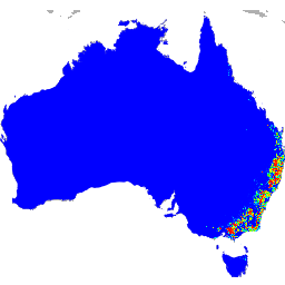
These species distribution model outputs, developed by Google in collaboration with QCIF and EcoCommons, represent estimates of species’ relative occurrence likelihoods (i.e., higher values indicate a higher likelihood that the species would be detected at a location, for a given survey methodology and given survey …
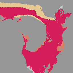
The iNaturalist Multispecies Range Dataset provides modeled geographic ranges for thousands of species. Dataset contains species polygons, with attributes such as taxon_id, name, scientific_name, and geomodel_version. Ranges are estimated from iNaturalist community observations and updated on a monthly basis. These datasets enable large-scale biodiversity analyses, …
[[["Easy to understand","easyToUnderstand","thumb-up"],["Solved my problem","solvedMyProblem","thumb-up"],["Other","otherUp","thumb-up"]],[["Missing the information I need","missingTheInformationINeed","thumb-down"],["Too complicated / too many steps","tooComplicatedTooManySteps","thumb-down"],["Out of date","outOfDate","thumb-down"],["Samples / code issue","samplesCodeIssue","thumb-down"],["Other","otherDown","thumb-down"]],[],[],[]]