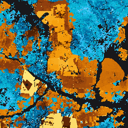
2016~2021년의 전 세계 기름야자 범위(10m 해상도) 및 1990~2021년의 기름야자 식재 연도(30m 해상도)입니다. 이 데이터 세트는 전 세계 열대 및 아열대 기름야자 재배 지역을 포괄하는 609개의 100x100km 그리드 타일로 구성되어 있으며, 2,398만 헥타르의 폐쇄형 기름야자 재배지를 매핑합니다.
[[["이해하기 쉬움","easyToUnderstand","thumb-up"],["문제가 해결됨","solvedMyProblem","thumb-up"],["기타","otherUp","thumb-up"]],[["필요한 정보가 없음","missingTheInformationINeed","thumb-down"],["너무 복잡함/단계 수가 너무 많음","tooComplicatedTooManySteps","thumb-down"],["오래됨","outOfDate","thumb-down"],["번역 문제","translationIssue","thumb-down"],["샘플/코드 문제","samplesCodeIssue","thumb-down"],["기타","otherDown","thumb-down"]],[],[],["The information describes four datasets related to agricultural land use. The first is a 2019 global map of oil palm plantations at 10m resolution, created using a neural network on satellite imagery. The other three are per-pixel probability models, also at 10m resolution, for cocoa, palm, and rubber trees respectively, all labeled as \"2024a\" and not peer-reviewed. These models estimate the probability of each area being occupied by these specific crops. All datasets are tagged with biodiversity, conservation, crop, and landuse.\n"]]