Datasets tagged nitrogen-dioxide in Earth Engine
Mit Sammlungen den Überblick behalten
Sie können Inhalte basierend auf Ihren Einstellungen speichern und kategorisieren.
Dieses große Vektordataset enthält eine hochauflösende Kartierung der Luftverschmutzung mit NO-, NO2-, O3-, CH4-, CO2-, BC-, PN2.5- und UFP-Konzentrationen in Kalifornien zwischen Juni 2015 und Juni 2019. Das Dataset besteht aus Messungen, die mit vier Google Street View-Fahrzeugen mit Aclima-Geräten erhoben wurden. …
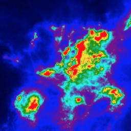
NRTI/L3_NO2: Dieses Dataset enthält hochauflösende Bilder von NO2-Konzentrationen, die nahezu in Echtzeit erstellt werden. Stickstoffoxide (NO2 und NO) sind wichtige Spurengase in der Erdatmosphäre, die sowohl in der Troposphäre als auch in der Stratosphäre vorkommen. Sie gelangen durch anthropogene Aktivitäten in die Atmosphäre (insbesondere durch die Verbrennung fossiler Brennstoffe …
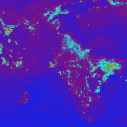
OFFL/L3_NO2: Dieses Dataset enthält Offline-Bilder von NO2-Konzentrationen in hoher Auflösung. Stickstoffoxide (NO2 und NO) sind wichtige Spurengase in der Erdatmosphäre, die sowohl in der Troposphäre als auch in der Stratosphäre vorkommen. Sie gelangen durch anthropogene Aktivitäten in die Atmosphäre (insbesondere durch die Verbrennung fossiler Brennstoffe …
[[["Leicht verständlich","easyToUnderstand","thumb-up"],["Mein Problem wurde gelöst","solvedMyProblem","thumb-up"],["Sonstiges","otherUp","thumb-up"]],[["Benötigte Informationen nicht gefunden","missingTheInformationINeed","thumb-down"],["Zu umständlich/zu viele Schritte","tooComplicatedTooManySteps","thumb-down"],["Nicht mehr aktuell","outOfDate","thumb-down"],["Problem mit der Übersetzung","translationIssue","thumb-down"],["Problem mit Beispielen/Code","samplesCodeIssue","thumb-down"],["Sonstiges","otherDown","thumb-down"]],[],[],[]]