Datasets tagged landscan in Earth Engine
Mit Sammlungen den Überblick behalten
Sie können Inhalte basierend auf Ihren Einstellungen speichern und kategorisieren.
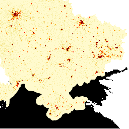
LandScan High Definition (HD) bietet Schätzungen der Bevölkerungszahl in Rasterzellen mit einer Auflösung von 3 Bogensekunden (~100 m). Die Werte für jede LandScan HD-Zelle stellen eine Schätzung der Bevölkerungszahl im Umfeld dar (24-Stunden-Durchschnitt). So erfassen die Daten den gesamten potenziellen Aktivitätsraum von Personen im Laufe des Tages.
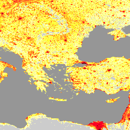
Das LandScan-Dataset des Oak Ridge National Laboratory (ORNL) bietet ein umfassendes globales Dataset zur Bevölkerungsverteilung mit hoher Auflösung, das eine wertvolle Ressource für eine Vielzahl von Anwendungen darstellt. LandScan nutzt modernste räumliche Modellierungstechniken und fortschrittliche georäumliche Datenquellen und bietet detaillierte …
[[["Leicht verständlich","easyToUnderstand","thumb-up"],["Mein Problem wurde gelöst","solvedMyProblem","thumb-up"],["Sonstiges","otherUp","thumb-up"]],[["Benötigte Informationen nicht gefunden","missingTheInformationINeed","thumb-down"],["Zu umständlich/zu viele Schritte","tooComplicatedTooManySteps","thumb-down"],["Nicht mehr aktuell","outOfDate","thumb-down"],["Problem mit der Übersetzung","translationIssue","thumb-down"],["Problem mit Beispielen/Code","samplesCodeIssue","thumb-down"],["Sonstiges","otherDown","thumb-down"]],[],[],["LandScan HD provides population estimates for Ukraine at a 3 arc-second (~100m) resolution, representing a 24-hour average population count per cell. LandScan Global, from Oak Ridge National Laboratory, offers a high-resolution global population distribution dataset. It utilizes spatial modeling and geospatial data to provide detailed population information for diverse applications. Both datasets are tagged with \"landscan\" and \"population,\" indicating their focus on population distribution analysis.\n"]]