Datasets tagged eea in Earth Engine
Mit Sammlungen den Überblick behalten
Sie können Inhalte basierend auf Ihren Einstellungen speichern und kategorisieren.
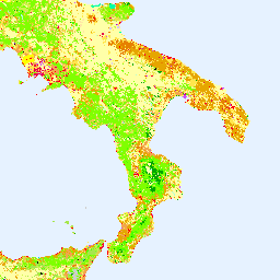
Das CORINE (Coordination of Information on the Environment) Land Cover (CLC) Inventory wurde 1985 ins Leben gerufen, um die Datenerhebung zu Land in Europa zu standardisieren und die Entwicklung der Umweltpolitik zu unterstützen. Das Projekt wird von der Europäischen Umweltagentur (EUA) im Rahmen der EU … koordiniert.
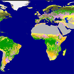
Der Copernicus Global Land Service (CGLS) ist als Komponente des Land Service vorgesehen, um eine Mehrzweck-Servicekomponente zu betreiben, die eine Reihe von biogeophysikalischen Produkten zum Status und zur Entwicklung der Landoberfläche auf globaler Ebene bereitstellt. Die dynamische Karte der Bodenbedeckung unter …
[[["Leicht verständlich","easyToUnderstand","thumb-up"],["Mein Problem wurde gelöst","solvedMyProblem","thumb-up"],["Sonstiges","otherUp","thumb-up"]],[["Benötigte Informationen nicht gefunden","missingTheInformationINeed","thumb-down"],["Zu umständlich/zu viele Schritte","tooComplicatedTooManySteps","thumb-down"],["Nicht mehr aktuell","outOfDate","thumb-down"],["Problem mit der Übersetzung","translationIssue","thumb-down"],["Problem mit Beispielen/Code","samplesCodeIssue","thumb-down"],["Sonstiges","otherDown","thumb-down"]],[],[],["The Copernicus program provides land cover data through two key initiatives. The CORINE Land Cover (CLC) inventory, initiated in 1985 and coordinated by the EEA, standardizes land data collection in Europe. The Copernicus Global Land Service (CGLS) offers bio-geophysical products and dynamic land cover maps at a global scale, providing insights into land surface status and evolution. Both use the European Union's resources, are associated with the European Environment Agency (EEA), European Space Agency (ESA), and focus on land cover.\n"]]