Page Summary
-
The USDA NASS Cropland Data Layer (CDL) is an annual crop-specific land cover data layer for the continental United States created using satellite imagery and agricultural ground truth.
-
GFSAD1000 provides high-resolution global cropland data and water use information, derived from multi-sensor remote sensing data, secondary data, and field-plot data.
-
USDA NASS Cropland Data Layers
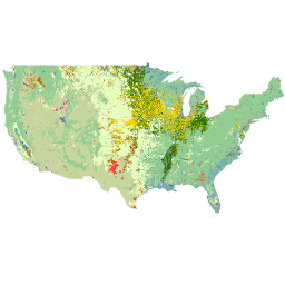
The Cropland Data Layer (CDL) is a crop-specific land cover data layer created annually for the continental United States using moderate resolution satellite imagery and extensive agricultural ground truth. The CDL is created by the USDA, National Agricultural Statistics Service (NASS), Research and Development Division, … cropland landcover usda -
GFSAD1000: Cropland Extent 1km Multi-Study Crop Mask, Global Food-Support Analysis Data
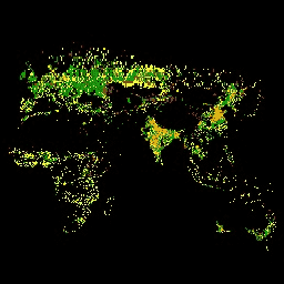
The GFSAD is a NASA-funded project to provide high-resolution global cropland data and their water use that contributes towards global food security in the twenty-first century. The GFSAD products are derived through multi-sensor remote sensing data (e.g., Landsat, MODIS, AVHRR), secondary data, and field-plot data … crop cropland landcover usgs