Datasets tagged cropland in Earth Engine
Mit Sammlungen den Überblick behalten
Sie können Inhalte basierend auf Ihren Einstellungen speichern und kategorisieren.
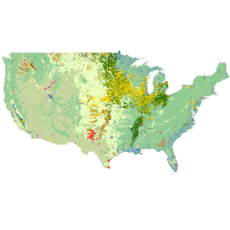
Die Cropland Data Layer (CDL) ist eine pflanzenspezifische Datenebene für die Bodenbedeckung, die jährlich für die kontinentalen USA mit Satellitenbildern mittlerer Auflösung und umfangreichen Bodenbeobachtungen in der Landwirtschaft erstellt wird. Die CDL wird vom USDA, National Agricultural Statistics Service (NASS), Research and Development Division, …
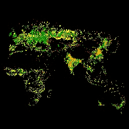
Das GFSAD ist ein von der NASA finanziertes Projekt, das hochauflösende Daten zu globalen Ackerflächen und deren Wassernutzung bereitstellt, um zur globalen Ernährungssicherheit im 21. Jahrhundert beizutragen. Die GFSAD-Produkte werden aus Multisensor-Remote-Szenendaten (z.B. Landsat, MODIS, AVHRR), Sekundärdaten und Felddaten …
[[["Leicht verständlich","easyToUnderstand","thumb-up"],["Mein Problem wurde gelöst","solvedMyProblem","thumb-up"],["Sonstiges","otherUp","thumb-up"]],[["Benötigte Informationen nicht gefunden","missingTheInformationINeed","thumb-down"],["Zu umständlich/zu viele Schritte","tooComplicatedTooManySteps","thumb-down"],["Nicht mehr aktuell","outOfDate","thumb-down"],["Problem mit der Übersetzung","translationIssue","thumb-down"],["Problem mit Beispielen/Code","samplesCodeIssue","thumb-down"],["Sonstiges","otherDown","thumb-down"]],[],[],["The USDA NASS Cropland Data Layer (CDL) is an annual, crop-specific land cover dataset for the continental US, derived from satellite imagery and ground data. The USGS GFSAD1000 project provides high-resolution global cropland data, including water use, utilizing multi-sensor remote sensing data, secondary sources, and field-plot data, to enhance global food security analysis. Both focus on cropland and land cover.\n"]]