-
CryoSat-2-DEM der Antarktis mit 1 km Auflösung
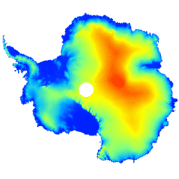
Dieses Dataset ist ein digitales Höhenmodell (Digital Elevation Model, DEM) des antarktischen Eisschilds und der antarktischen Schelfeise. Es basiert auf Beobachtungen, die zwischen Juli 2010 und Juli 2016 vom Radaraltimeter des CryoSat-2-Satelliten aufgezeichnet wurden. Das DEM wird aus räumlich-zeitlichen Anpassungen an Höhenmessungen erstellt, die innerhalb von 1, … antarctica dem elevation elevation-topography polar -
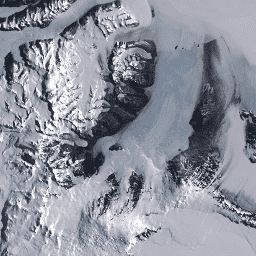
Landsat Image Mosaic of Antarctica (LIMA) – verarbeitete Landsat-Szenen (16 Bit)

Das Landsat Image Mosaic of Antarctica (LIMA) ist ein nahtloses und nahezu wolkenloses Mosaik, das aus verarbeiteten Landsat 7 ETM+-Szenen erstellt wurde. Verarbeitete Landsat-Szenen (16 Bit) sind NLAPS-Szenen der Stufe 1Gt, die in 16 Bit konvertiert, mit einer Korrektur des Sonnenwinkels verarbeitet und in Reflexionswerte umgewandelt wurden (Bindschadler … antarctica ice landsat-derived lima mosaic satellite-imagery -
Landsat Image Mosaic of Antarctica (LIMA) – Metadaten zu verarbeiteten Landsat-Szenen (16 Bit)
Das Landsat Image Mosaic of Antarctica (LIMA) ist ein nahtloses und nahezu wolkenloses Mosaik, das aus verarbeiteten Landsat 7 ETM+-Szenen erstellt wurde. Verarbeitete Landsat-Szenen (16 Bit) sind NLAPS-Szenen der Stufe 1Gt, die in 16 Bit konvertiert, mit einer Korrektur des Sonnenwinkels verarbeitet und in Reflexionswerte umgewandelt wurden (Bindschadler … antarctica ice landsat-derived lima mosaic satellite-imagery -
Landsat Image Mosaic of Antarctica (LIMA) – 16-Bit-Mosaik mit Pan-Sharpening
Das Landsat Image Mosaic of Antarctica (LIMA) ist ein nahtloses und nahezu wolkenloses Mosaik, das aus verarbeiteten Landsat 7 ETM+-Szenen erstellt wurde. Dieses LIMA-Dataset ist das 16-Bit-Zwischenprodukt von LIMA. Das Mosaik besteht aus Szenen mit normalisierter Oberflächenreflexion mit Pan-Sharpening (Landsat ETM+-Bänder 1, 2, 3 und … antarctica ice landsat-derived lima mosaic satellite-imagery