- Dataset-Verfügbarkeit
- 2010-07-01T00:00:00Z–2016-07-01T00:00:00Z
- Ersteller des Datasets
- CPOM
- Tags
Beschreibung
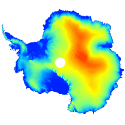
Dieses Dataset ist ein digitales Höhenmodell (Digital Elevation Model, DEM) des antarktischen Eisschilds und der Schelfeisgebiete, das auf Beobachtungen basiert, die zwischen Juli 2010 und Juli 2016 vom Radar-Höhenmesser des CryoSat-2-Satelliten aufgezeichnet wurden.
Das DEM wird aus räumlich-zeitlichen Anpassungen an Höhenmessungen gebildet, die in 1-, 2- und 5‑km-Rasterzellen erfasst wurden, und wird mit der modalen Auflösung von 1 km veröffentlicht. Der Median und die quadratische Mittelwertabweichung zwischen dem DEM und 2,3*107; während der NASA Operation IceBridge-Kampagnen erfasste Airborne Laser Altimeter-Messungen betragen -0,30 bzw. 13,50 m.
Die DEM-Unsicherheit steigt in Regionen mit hoher Neigung, insbesondere dort, wo Höhenmessungen im Modus mit niedriger Auflösung erfasst wurden.Unter Berücksichtigung dieser Faktoren schätzen wir die durchschnittliche Genauigkeit auf 9,5 m.
Bänder
Bänder
Pixelgröße: 1.000 Meter (alle Bänder)
| Name | Einheiten | Pixelgröße | Beschreibung |
|---|---|---|---|
elevation |
m | 1.000 Meter | Höhe der Eisdecke und des Schelfeises der Antarktis. |
data_composition |
1.000 Meter | Methode zur Verarbeitung von Höhendaten pro Rasterzelle. |
|
slope |
Grad | 1.000 Meter | Die Neigung wird aus dem Höhengradienten abgeleitet. |
z_smoothed |
m | 1.000 Meter | Geglättete Version des Höhenmodells mit einem Medianfilter. |
z_uncertainty |
m | 1.000 Meter | Sicherheit des aus dem RMS der Höhenresiduen in beobachteten Rasterzellen und dem Kriging-Varianzfehler in interpolierten Rasterzellen abgeleiteten Höhenmodells. |
Klassentabelle für data_composition
| Wert | Farbe | Beschreibung |
|---|---|---|
| 0 | #000000 | interpoliert |
| 1 | #cbcbcb | 1-km-Lauf |
| 2 | #377eb7 | Neu berechnete Anpassung für 2 km |
| 3 | #e2191b | Neu berechnete Anpassung für 5 km |
Nutzungsbedingungen
Nutzungsbedingungen
Zitationen
Slater, T., Shepherd, A., McMillan, M., Muir, A., Gilbert, L., Hogg, A. E., Konrad, H. und Parrinello, T.: Ein neues digitales Höhenmodell der Antarktis, abgeleitet aus CryoSat-2-Altimetrie, The Cryosphere, doi:10.5194/tc-2017-223, 2018
DOIs
Die Earth Engine nutzen
Code-Editor (JavaScript)
var dataset = ee.Image('CPOM/CryoSat2/ANTARCTICA_DEM');

var visualization = {
  bands: ['elevation'],
  min: 0.0,
  max: 4000.0,
  palette: ['001fff', '00ffff', 'fbff00', 'ff0000']
};

Map.setCenter(17.0, -76.0, 3);

Map.addLayer(dataset, visualization, 'Elevation');