-
JRC Yearly Water Classification History, v1.4
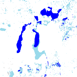
This dataset contains maps of the location and temporal distribution of surface water from 1984 to 2021 and provides statistics on the extent and change of those water surfaces. For more information see the associated journal article: High-resolution mapping of global surface water and its … annual geophysical google history jrc landsat-derived -
Global Mangrove Forests Distribution, v1 (2000)
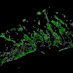
The database was prepared using Landsat satellite data from the year 2000. More than 1,000 Landsat scenes obtained from the USGS Earth Resources Observation and Science Center (EROS) were classified using hybrid supervised and unsupervised digital image classification techniques. This database is the first, most … annual ciesin global landsat-derived mangrove nasa -
MOD44B.006 Terra Vegetation Continuous Fields Yearly Global 250m
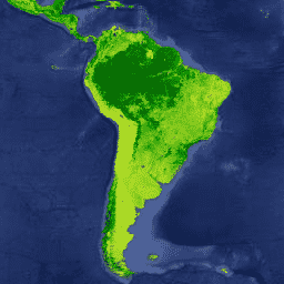
The Terra MODIS Vegetation Continuous Fields (VCF) product is a sub-pixel-level representation of surface vegetation cover estimates globally. Designed to continuously represent Earth's terrestrial surface as a proportion of basic vegetation traits, it provides a gradation of three surface cover components: percent tree cover, percent … annual geophysical global modis nasa terra -
VIIRS Nighttime Day/Night Annual Band Composites V2.1
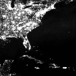
Annual global VIIRS nighttime lights dataset is a time series produced from monthly cloud-free average radiance grids spanning 2013 to 2021. Data for 2022 are available in the NOAA/VIIRS/DNB/ANNUAL_V22 dataset. An initial filtering step removed sunlit, moonlit and cloudy pixels, leading to rough composites that … annual dnb eog lights nighttime noaa -
VIIRS Nighttime Day/Night Annual Band Composites V2.2

Annual global VIIRS nighttime lights dataset is a time series produced from monthly cloud-free average radiance grids for 2022. Data for earlier years are available in the NOAA/VIIRS/DNB/ANNUAL_V21 dataset. An initial filtering step removed sunlit, moonlit and cloudy pixels, leading to rough composites that contains … annual dnb eog lights nighttime noaa
[{
"type": "thumb-down",
"id": "missingTheInformationINeed",
"label":"Missing the information I need"
},{
"type": "thumb-down",
"id": "tooComplicatedTooManySteps",
"label":"Too complicated / too many steps"
},{
"type": "thumb-down",
"id": "outOfDate",
"label":"Out of date"
},{
"type": "thumb-down",
"id": "samplesCodeIssue",
"label":"Samples / code issue"
},{
"type": "thumb-down",
"id": "otherDown",
"label":"Other"
}]
[{
"type": "thumb-up",
"id": "easyToUnderstand",
"label":"Easy to understand"
},{
"type": "thumb-up",
"id": "solvedMyProblem",
"label":"Solved my problem"
},{
"type": "thumb-up",
"id": "otherUp",
"label":"Other"
}]