-
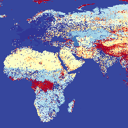
Malaria Atlas Project Accessibility to Cities 2015
แผนที่การเข้าถึงทั่วโลกนี้แสดงเวลาในการเดินทางทางบกไปยังพื้นที่ที่มีประชากรหนาแน่นที่สุดที่ใกล้ที่สุดสำหรับทุกพื้นที่ระหว่าง 85 องศาเหนือและ 60 องศาใต้ในปี 2015 พื้นที่ที่มีประชากรหนาแน่นหมายถึงพื้นที่ที่อยู่ติดกันซึ่งมีประชากร 1,500 คนขึ้นไปต่อตารางกิโลเมตร หรือ… accessibility malariaatlasproject map population publisher-dataset -
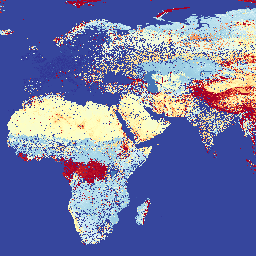
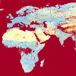
Malaria Atlas Project Accessibility to Healthcare 2019
แผนที่การช่วยเหลือพิเศษทั่วโลกนี้แสดงเวลาในการเดินทางภาคพื้นดิน (เป็นนาที) ไปยังโรงพยาบาลหรือคลินิกที่ใกล้ที่สุดสำหรับทุกพื้นที่ระหว่าง 85 องศาเหนือและ 60 องศาใต้ในปี 2019 ความพยายามในการเก็บรวบรวมข้อมูลครั้งใหญ่ที่ OpenStreetMap, Google Maps และนักวิจัยด้านวิชาการกำลังดำเนินการอยู่ได้ … accessibility malariaatlasproject map population publisher-dataset -
Malaria Atlas Project Accessibility to Healthcare 2019 (เดินเท่านั้น)
แผนที่การช่วยเหลือพิเศษทั่วโลกนี้แสดงเวลาในการเดินทางภาคพื้นดิน (เป็นนาที) ไปยังโรงพยาบาลหรือคลินิกที่ใกล้ที่สุดสำหรับทุกพื้นที่ระหว่าง 85 องศาเหนือและ 60 องศาใต้ในปี 2019 พื้นผิวนี้อิงตามเวลาเดินทาง "เดินเท้าเท่านั้น" โดยใช้รูปแบบการเดินทางที่ไม่ใช่เครื่องยนต์กลไก … accessibility malariaatlasproject map population publisher-dataset -
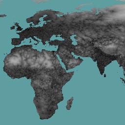
พื้นผิวแรงเสียดทานทั่วโลกของโครงการแผนที่มาลาเรีย ปี 2015
Friction Surface 2019" พื้นผิวแรงเสียดทานทั่วโลกนี้แสดงความเร็วในการเดินทางบนบกสำหรับพิกเซลบนบกทั้งหมดระหว่างละติจูด 85 องศาเหนือและ 60 องศาใต้สำหรับปี 2015 แผนที่นี้จัดทำขึ้นผ่านความร่วมมือระหว่างโครงการแผนที่มาลาเรียของมหาวิทยาลัยอ็อกซ์ฟอร์ด (MAP), Google, … accessibility malariaatlasproject map population publisher-dataset -
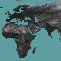
พื้นผิวแรงเสียดทานทั่วโลกของ Malaria Atlas Project ปี 2019
พื้นผิวแรงเสียดทานทั่วโลกนี้จะแสดงความเร็วในการเดินทางบนบกสำหรับพิกเซลบนบกทั้งหมดระหว่างละติจูด 85 องศาเหนือและ 60 องศาใต้สำหรับปี 2019 แผนที่นี้จัดทำขึ้นโดยความร่วมมือระหว่าง MAP (มหาวิทยาลัยอ็อกซ์ฟอร์ด), Telethon Kids Institute (เพิร์ท ออสเตรเลีย), Google และ … accessibility malariaatlasproject map population publisher-dataset -
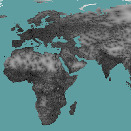
พื้นผิวแรงเสียดทานทั่วโลกของ Malaria Atlas Project ปี 2019 (เดินเท่านั้น)
พื้นผิวแรงเสียดทานทั่วโลกนี้จะแสดงความเร็วในการเดินทางบนบกสำหรับพิกเซลบนบกทั้งหมดระหว่างละติจูด 85 องศาเหนือและ 60 องศาใต้สำหรับปี 2019 พื้นผิวนี้อิงตามความเร็วในการเดินทางแบบ "เดินเท่านั้น" โดยใช้ยานพาหนะที่ไม่ใช่เครื่องยนต์เท่านั้น แผนที่นี้จัดทำขึ้นผ่าน … accessibility malariaatlasproject map population publisher-dataset