- Catalog Owner
- OpenET
- Dataset Availability
- 2015-10-01T00:00:00Z–2026-06-01T00:00:00Z
- Dataset Producer
- OpenET, Inc.
- Contact
- support@openetdata.org
- Cadence
- 1 Month
- Tags
Description
Operational Simplified Surface Energy Balance (SSEBop).
The Operational Simplified Surface Energy Balance (SSEBop) model (Senay et al., 2013; 2023) is a thermal based approach for estimating actual evapotranspiration (ET) using the principles of satellite psychrometry (Senay, 2018). As one of the core models in the OpenET ensemble, SSEBop provides a computationally efficient framework for large- area, operational ET mapping.
The OpenET Collection 2.1 implementation of SSEBop relies on two primary inputs:
- Land surface temperature from Landsat Collection 2 Level 2 Science Products.
- Gridded reference ET from gridMET (Abotzoglou, 2013).
Key model parameters, including the cold/wet bulb reference temperature (Tc) and the surface psychrometric constant (1/dT), are derived using a combination of observed surface temperature, normalized difference vegetation index (NDVI), and ERA5 net radiation data (DOI: 10.5066/P9JBW6R9). These components are integrated within the Google Earth Engine processing environment, which links the full suite of SSEBop algorithms to generate both intermediate outputs and aggregated ET products. Extensive evaluation across the conterminous United States (Senay et al., 2022; Volk et al., 2024; Ji et al., 2025; Khand et al, 2025) has guided the cloud-based implementation and demonstrated the model’s utility for applications such as crop water use assessment and regional water budget analysis.
For OpenET Collection 2.1, SSEBop model v0.7.1 (Senay et al., 2026) includes a notable enhancement: an improved implementation of the Forcing and Normalizing Operation (FANO) equation for determining Tc. This update strengthens the model’s ability to represent wet surfaces with low NDVI, improving performance in areas where vegetation signals are weak or mixed, particularly over farmlands and grasslands during sparse canopy cover. OpenET Collection v2.1
OpenET Collection v2.1 is a reprocessed and updated version of Collection v2.0, designed primarily to address known v2.0 issues, while also incorporating minor model improvements and input-data updates. It is expected that there will be noticeable differences in ET between the two collection versions for some places and times. Some of the updates and changes include:
- Additional cloud screening and filtering to skip Landsat images with unmasked clouds and/or extensive snow cover.
- Reprocessing to incorporate updates to the NLDAS-2 and GRIDMET input meteorology datasets.
- Incorporation of the USGS Annual NLCD product for all models that require land cover information.
- Incorporation of the latest USDA CDL for all models that require crop type information.
- Updates to the interpolation so monthly ET is only produced when all days in the month have interpolated values (reducing “count=0” months in cloudy/snowy or low-coverage periods).
- Application of an emissivity correction to address a known issue in Landsat LST data.
Bands
Bands
Pixel size: 30 meters (all bands)
| Name | Units | Pixel Size | Description |
|---|---|---|---|
et |
mm | 30 meters | Total actual evapotranspiration (ET) |
count |
count | 30 meters | Number of cloud free observations in the month included in the interpolation |
Image Properties
Image Properties
| Name | Type | Description |
|---|---|---|
| build_date | STRING | Date assets were built |
| build_status | STRING | Status can be "permanent" or "provisional". Images flagged as "provisional" may be updated in the future. |
| cloud_cover_max | DOUBLE | Maximum CLOUD_COVER_LAND percent value for Landsat images included in interpolation |
| collections | STRING | List of Landsat collections for Landsat images included in the interpolation |
| core_version | STRING | OpenET core library version |
| end_date | STRING | End date of month |
| et_reference_band | STRING | Band in et_reference_source that contains the daily reference ET data |
| et_reference_resample | STRING | Spatial interpolation mode to resample daily reference ET data |
| et_reference_source | STRING | Collection ID for the daily reference ET data |
| image_source_count | DOUBLE | Number of scene images used in the interpolation |
| interp_days | DOUBLE | Maximum number of days before and after each image date to include in interpolation |
| interp_method | STRING | Method used to interpolate between Landsat model estimates |
| interp_source_count | DOUBLE | Number of available images in the interpolation source image collection for the target month |
| mgrs_tile | STRING | MGRS grid zone ID |
| model_name | STRING | OpenET model name |
| model_version | STRING | OpenET model version |
| scale_factor_count | DOUBLE | Scaling factor that should be applied to the count band |
| scale_factor_et | DOUBLE | Scaling factor that should be applied to the et band |
| start_date | STRING | Start date of month |
| units_et | STRING | Units of the "et" band |
Terms of Use
Terms of Use
Citations
Senay, G.B., Parrish, G.E., Schauer, M., Friedrichs, M., Khand, K., Boiko, O., Kagone, S., Dittmeier, R., Arab, S. and Ji, L., 2023. Improving the Operational Simplified Surface Energy Balance Evapotranspiration Model Using the Forcing and Normalizing Operation. Remote Sensing, 15(1), p.260. doi:10.3390/rs15010260
Senay, G.B., Bohms, S., Singh, R.K., Gowda, P.H., Velpuri, N.M., Alemu, H. and Verdin, J.P., 2013. Operational evapotranspiration mapping using remote sensing and weather datasets: A new parameterization for the SSEB approach. JAWRA Journal of the American Water Resources Association, 49(3), pp.577-591. doi:10.1111/jawr.12057
Senay, G.B., Schauer, M., Friedrichs, M., Velpuri, N.M. and Singh, R.K., 2017. Satellite-based water use dynamics using historical Landsat data (1984–2014) in the southwestern United States. Remote Sensing of Environment, 202, pp.98-112. doi:10.1016/j.rse.2017.05.005c
Senay, G.B., 2018. Satellite psychrometric formulation of the Operational Simplified Surface Energy Balance (SSEBop) model for quantifying and mapping evapotranspiration. Applied Engineering in Agriculture, 34(3), pp.555-566. doi:10.13031/aea.12614
Senay, G.B., Friedrichs, M., Morton, C., Parrish, G.E., Schauer, M., Khand, K., Kagone, S., Boiko, O. and Huntington, J., 2022. Mapping actual evapotranspiration using Landsat for the conterminous United States: Google Earth Engine implementation and assessment of the SSEBop model. Remote Sensing of Environment, 275, p.113011. doi:10.1016/j.rse.2022.113011
DOIs
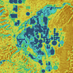
Explore with Earth Engine
Code Editor (JavaScript)
var dataset = ee.ImageCollection('projects/openet/assets/ssebop/conus/gridmet/monthly/v2_1')
  .filterDate('2024-01-01', '2025-01-01');

// Compute the annual evapotranspiration (ET) as the sum of the monthly ET
// images for the year.
var et = dataset.select('et').sum();

var visualization = {
  min: 0,
  max: 1400,
  palette: [
    '9e6212', 'ac7d1d', 'ba9829', 'c8b434', 'd6cf40', 'bed44b', '9fcb51',
    '80c256', '61b95c', '42b062', '45b677', '49bc8d', '4dc2a2', '51c8b8',
    '55cece', '4db4ba', '459aa7', '3d8094', '356681', '2d4c6e',
  ]
};

Map.setCenter(-100, 38, 5);

Map.addLayer(et, visualization, 'OpenET SSEBop Annual ET');