- Catalog Owner
- MapBiomas
- Dataset Availability
- 1985-01-01T00:00:00Z–2024-12-31T00:00:00Z
- Dataset Producer
- MapBiomas
- Contact
- contato@mapbiomas.org
- Tags
Description
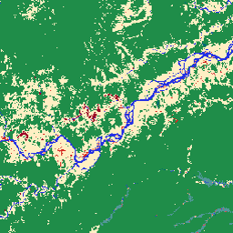
MapBiomas Land Use and Land Cover (LULC) dataset for Ecuador is produced annually by the MapBiomas Project using Landsat satellite imagery and machine learning classification techniques. The dataset provides consistent annual land cover maps at 30-meter resolution covering the period from 1985 to 2024.
Ecuador's territory encompasses four distinct natural regions: the Amazon (Oriente), the Andes highlands (Sierra), the Pacific Coast (Costa), and the Galapagos Islands. This geographic diversity is reflected in the classification legend, which includes classes specific to Ecuadorian ecosystems such as Andean herbaceous and shrubby vegetation, flooded Andean herbaceous, mangrove, and banana plantations.
Each image in the collection contains one band named "classification", with integer values representing categorical land cover classes for that year. The classification is based on Landsat 5 (TM), Landsat 7 (ETM+), Landsat 8 and 9 (OLI/TIRS) surface reflectance data, preprocessed to generate annual cloud-free composites. The classification process uses automated decision trees trained with reference samples and validated by regional experts.
For more information, classification legend, methodology, and accuracy assessments, visit the MapBiomas website.
Bands
Bands
Pixel size: 30 meters (all bands)
| Name | Pixel Size | Description |
|---|---|---|
classification |
30 meters | Land use and land cover classification, with integer values corresponding to MapBiomas Ecuador legend classes. |
classification Class Table
| Value | Color | Description |
|---|---|---|
| 1 | #1f8d49 | Natural forest |
| 3 | #1f8d49 | Forest |
| 4 | #7dc975 | Open forest |
| 5 | #04381d | Mangrove |
| 6 | #026975 | Flooded forest |
| 9 | #7a5900 | Silviculture |
| 10 | #d6bc74 | Non-forest natural formation |
| 11 | #519799 | Non forest wetland |
| 12 | #d6bc74 | Grassland |
| 13 | #d89f5c | Other non-forest natural formation |
| 14 | #ffefc3 | Farming and silviculture |
| 21 | #ffefc3 | Mosaic of uses |
| 22 | #d4271e | Non-vegetated area |
| 23 | #ffa07a | Beach, dune and sand spot |
| 24 | #d4271e | Urban infrastructure |
| 25 | #db4d4f | Other anthropic non-vegetated area |
| 26 | #2532e4 | Water |
| 27 | #ffffff | Not observed |
| 29 | #ffaa5f | Rocky outcrop |
| 30 | #9c0027 | Mining |
| 31 | #091077 | Aquaculture |
| 33 | #2532e4 | River, lake and ocean |
| 34 | #93dfe6 | Glacier |
| 68 | #e97a7a | Other natural non-vegetated area |
| 74 | #be83f7 | Banana |
| 81 | #dfeb62 | Andean Herbaceous and Shrubby Vegetation |
| 82 | #6fc179 | Flooded Andean Herbaceous |
Image Properties
Image Properties
| Name | Type | Description |
|---|---|---|
| year | INT | Year of the land use and land cover classification. |
| version | STRING | Version of the land use and land cover classification. |
| collection_id | DOUBLE | Collection identifier of the land use and land cover classification. |
Terms of Use
Terms of Use
Citations
Souza et al. (2020) - Reconstructing Three Decades of Land Use and Land Cover Changes in Brazilian Biomes with Landsat Archive and Earth Engine - Remote Sensing, Volume 12, Issue 17, 10.3390/rs12172735.
DOIs
Explore with Earth Engine
Code Editor (JavaScript)
/**
  MapBiomas Ecuador - Land Use and Land Cover V1
*/

var assetPath = 'projects/mapbiomas-public/assets/ecuador/lulc/v1';

var year = 2024;

var collection = ee.ImageCollection(assetPath)
  .filter(ee.Filter.eq('year', year));

var visParams = {
  min: 0,
  max: 82,
  palette: [
    '000000',  // [0] --
    '1f8d49',  // [1] Natural forest
    '000000',  // [2] --
    '1f8d49',  // [3] Forest
    '7dc975',  // [4] Open forest
    '04381d',  // [5] Mangrove
    '026975',  // [6] Flooded forest
    '000000',  // [7] --
    '000000',  // [8] --
    '7a5900',  // [9] Silviculture
    'd6bc74',  // [10] Non-forest natural formation
    '519799',  // [11] Non forest wetland
    'd6bc74',  // [12] Grassland
    'd89f5c',  // [13] Other non-forest natural formation
    'ffefc3',  // [14] Farming and silviculture
    '000000',  // [15] --
    '000000',  // [16] --
    '000000',  // [17] --
    '000000',  // [18] --
    '000000',  // [19] --
    '000000',  // [20] --
    'ffefc3',  // [21] Mosaic of uses
    'd4271e',  // [22] Non-vegetated area
    'ffa07a',  // [23] Beach, dune and sand spot
    'd4271e',  // [24] Urban infrastructure
    'db4d4f',  // [25] Other anthropic non-vegetated area
    '2532e4',  // [26] Water
    'ffffff',  // [27] Not observed
    '000000',  // [28] --
    'ffaa5f',  // [29] Rocky outcrop
    '9c0027',  // [30] Mining
    '091077',  // [31] Aquaculture
    '000000',  // [32] --
    '2532e4',  // [33] River, lake and ocean
    '93dfe6',  // [34] Glacier
    '000000',  // [35] --
    '000000',  // [36] --
    '000000',  // [37] --
    '000000',  // [38] --
    '000000',  // [39] --
    '000000',  // [40] --
    '000000',  // [41] --
    '000000',  // [42] --
    '000000',  // [43] --
    '000000',  // [44] --
    '000000',  // [45] --
    '000000',  // [46] --
    '000000',  // [47] --
    '000000',  // [48] --
    '000000',  // [49] --
    '000000',  // [50] --
    '000000',  // [51] --
    '000000',  // [52] --
    '000000',  // [53] --
    '000000',  // [54] --
    '000000',  // [55] --
    '000000',  // [56] --
    '000000',  // [57] --
    '000000',  // [58] --
    '000000',  // [59] --
    '000000',  // [60] --
    '000000',  // [61] --
    '000000',  // [62] --
    '000000',  // [63] --
    '000000',  // [64] --
    '000000',  // [65] --
    '000000',  // [66] --
    '000000',  // [67] --
    'e97a7a',  // [68] Other natural non-vegetated area
    '000000',  // [69] --
    '000000',  // [70] --
    '000000',  // [71] --
    '000000',  // [72] --
    '000000',  // [73] --
    'be83f7',  // [74] Banana
    '000000',  // [75] --
    '000000',  // [76] --
    '000000',  // [77] --
    '000000',  // [78] --
    '000000',  // [79] --
    '000000',  // [80] --
    'dfeb62',  // [81] Andean Herbaceous and Shrubby Vegetation
    '6fc179',  // [82] Flooded Andean Herbaceous
  ],
};

Map.addLayer(collection, visParams, 'MapBiomas Ecuador LULC ' + year);
Map.centerObject(collection, 7);