Page Summary
-
This dataset provides per-pixel probability of palm presence at 10-meter resolution, generated by a machine learning model for the years 2020 and 2023.
-
The dataset's primary purpose is to support the Forest Data Partnership's mission to combat forest loss from commodity production.
-
Use of this dataset is subject to specific terms, with different conditions for commercial and non-commercial users of Earth Engine.
-
This dataset has been superseded by a newer version and is not yet peer-reviewed.
- Catalog Owner
- Forest Data Partnership
- Dataset Availability
- 2020-01-01T00:00:00Z–2023-12-31T23:59:59Z
- Dataset Producer
- Produced by Google for the Forest Data Partnership
- Tags
Description
Note: This dataset is not yet peer-reviewed. Please see the GitHub README associated with this model for more information.
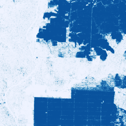
This image collection provides per-pixel probability that the underlying area is occupied by palm.
The probability estimates are provided at 10 meter resolution, and have been generated by a machine learning model. This dataset corresponds to 2020 and 2023 output from model 2024a in the Forest Data Partnership repo on Github.
The primary purpose of this image collection is to support the mission of the Forest Data Partnership which aims to halt and reverse forest loss from commodity production by collaboratively improving global monitoring, supply chain tracking, and restoration.
Note that this dataset has separate terms of use for commercial users of Earth Engine. Please see "Terms of Use" tab for details.
This community data product is meant to evolve over time, as more data becomes available from the community and the model used to produce the maps continuously improves. To provide map-based feedback on this collection, please see our Collect Earth Online instance and follow these instructions.
If you would like to provide general feedback or additional datasets to improve these layers, please reach out through this form.
Bands
Pixel Size
10 meters
Bands
| Name | Min | Max | Pixel Size | Description |
|---|---|---|---|---|
probability |
0 | 1 | meters | Probability that the pixel includes palm trees for the given year. |
Terms of Use
Terms of Use
For non-commercial users of Earth Engine, use of the dataset is subject to CC-BY 4.0 NC license and requires the following attribution: "Produced by Google for the Forest Data Partnership".
Commercial use of the dataset is subject to the Forest Data Partnership Datasets Commercial Terms of Use.
Contains modified Copernicus Sentinel data [2015-present]. See the Sentinel Data Legal Notice.
Citations
N. Clinton, et al. A community palm model. 2024. Online
DOIs
Explore with Earth Engine
Code Editor (JavaScript)
Map.setCenter(110, 0, 11);

var collection = ee.ImageCollection(
    'projects/forestdatapartnership/assets/palm/model_2024a');

var p2020 = collection.filterDate('2020-01-01', '2020-12-31').mosaic();
Map.addLayer(
    p2020.selfMask(), {min: 0.5, max: 1, palette: 'white,blue'}, 'palm 2020');

var p2023 = collection.filterDate('2023-01-01', '2023-12-31').mosaic();
Map.addLayer(
    p2023.selfMask(), {min: 0.5, max: 1, palette: 'white,green'}, 'palm 2023');