Page Summary
-
The Forest Data Partnership focuses on global monitoring of deforestation, degradation, and restoration related to commodities.
-
This page provides access to datasets including commodity probability models for cocoa, coffee, palm, and rubber trees, as well as a forest persistence dataset.
-
The commodity probability models estimate the likelihood of a pixel being occupied by a specific commodity at 10-meter resolution.
-
The Forest Persistence dataset indicates whether a pixel area was occupied by undisturbed forest in 2020.
-
Note that the datasets currently available are not yet peer-reviewed.
The Forest Data Partnership strengthens collaboration and application around global monitoring of commodity-driven deforestation, forest degradation and restoration efforts across the globe.
-
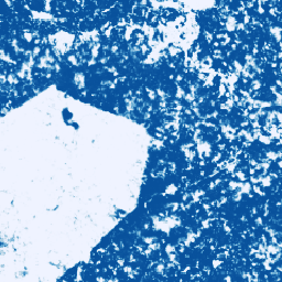
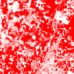
Cocoa Probability model 2025a

This image collection provides estimated per-pixel probability that the underlying area is occupied by the commodity. The probability estimates are provided at 10 meter resolution, and have been generated by a machine learning model. For details, see the technical documentation on the Forest Data Partnership … agriculture biodiversity cocoa conservation crop eudr -
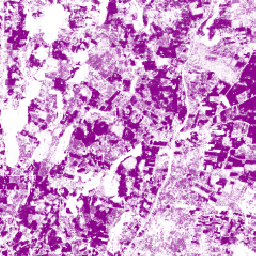
Cocoa Probability model 2025b
This image collection provides estimated per-pixel probability that the underlying area is occupied by the commodity. The probability estimates are provided at 10 meter resolution, and have been generated by a machine learning model. For details, see the technical documentation on the Forest Data Partnership … agriculture alphaearth-derived biodiversity cocoa conservation crop -
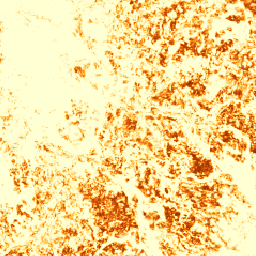
Coffee Probability model 2025a

This image collection provides estimated per-pixel probability that the underlying area is occupied by the commodity. The probability estimates are provided at 10 meter resolution, and have been generated by a machine learning model. For details, see the technical documentation on the Forest Data Partnership … agriculture biodiversity coffee conservation crop eudr -
Coffee Probability model 2025b
This image collection provides estimated per-pixel probability that the underlying area is occupied by the commodity. The probability estimates are provided at 10 meter resolution, and have been generated by a machine learning model. For details, see the technical documentation on the Forest Data Partnership … agriculture alphaearth-derived biodiversity coffee conservation crop -
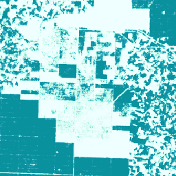
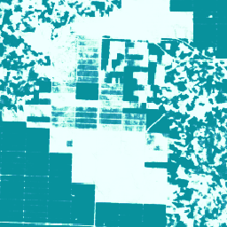
Forest Persistence v0

This image provides a per-pixel score (in [0, 1]) that indicates whether the pixel area is occupied by undisturbed forest in year 2020. These scores are provided at 30 meter resolution, and have been generated by a convergence of evidence approach to combining multiple forest … biodiversity conservation deforestation eudr forest-biomass forestdatapartnership -
Palm Probability model 2025a
This image collection provides estimated per-pixel probability that the underlying area is occupied by the commodity. The probability estimates are provided at 10 meter resolution, and have been generated by a machine learning model. For details, see the technical documentation on the Forest Data Partnership … agriculture biodiversity conservation crop eudr forestdatapartnership -
Palm Probability model 2025b
This image collection provides estimated per-pixel probability that the underlying area is occupied by the commodity. The probability estimates are provided at 10 meter resolution, and have been generated by a machine learning model. For details, see the technical documentation on the Forest Data Partnership … agriculture alphaearth-derived biodiversity conservation crop eudr -
Rubber Probability model 2025b
This image collection provides estimated per-pixel probability that the underlying area is occupied by the commodity. The probability estimates are provided at 10 meter resolution, and have been generated by a machine learning model. For details, see the technical documentation on the Forest Data Partnership … agriculture alphaearth-derived biodiversity conservation crop eudr -
Rubber Tree Probability model 2025a
This image collection provides estimated per-pixel probability that the underlying area is occupied by the commodity. The probability estimates are provided at 10 meter resolution, and have been generated by a machine learning model. For details, see the technical documentation on the Forest Data Partnership … agriculture biodiversity conservation crop eudr forestdatapartnership