- Disponibilidade do conjunto de dados
- 2012-01-01T00:00:00Z–2019-05-18T00:00:00Z
- Produtor de conjunto de dados
- World Resources Institute / Global Forest Watch
- Tags
Descrição
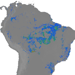
OBSERVAÇÃO do WRI: o WRI decidiu parar de atualizar os alertas do FORMA. O objetivo era simplificar a experiência do usuário do Global Forest Watch e reduzir a redundância. Descobrimos que Terra-i e GLAD eram usados com mais frequência. Além disso, usando o GLAD como padrão, descobrimos que o Terra-i teve uma performance melhor que o FORMA no mundo todo.
Os alertas do FORMA são detectados usando uma combinação de dois produtos do MODIS: NDVI (Índice de Vegetação por Diferença Normalizada) e FIRMS (Sistema de Informações sobre Incêndios para Gerenciamento de Recursos). As atualizações do NDVI são processadas a cada 16 dias, enquanto as de incêndios são processadas diariamente. Os modelos são desenvolvidos individualmente para cada ecogrupo e relacionam as duas entradas à área de desmatamento, usando os dados anuais de perda de cobertura florestal de Hansen para treinar o modelo. O limite mínimo para se qualificar como um alerta é de 25% dos pixels limpos, mas os limites variam de acordo com o ecogrupo para minimizar falsos positivos. Confira um exemplo de script para uma introdução rápida aos conjuntos de dados da FORMA.
A porcentagem de desmatamento assume um valor de 0, nenhum desmatamento detectado ou no intervalo [ecogroup_bound:100), em que ecogroup_bound é dado por WRI/GFW/FORMA/thresholds . Os períodos em que os dados são coletados variam de acordo com N dias, em que N é o número de dias entre alert_date e a última atualização do NDVI do MODIS.
Bandas
Bandas
Tamanho do pixel: 250 metros (todas as bandas)
| Nome | Unidades | Mín. | Máx. | Tamanho do pixel | Descrição |
|---|---|---|---|---|---|
alert_delta |
% | 0 | 100 | 250 metros | Porcentagem de limpeza durante os seis períodos do MODIS (96 + N dias) que antecedem o valor de alert_date correspondente para o pixel. |
alert_date |
ms | 250 metros | Carimbo de data/hora em milissegundos desde 01/01/1970 |
Propriedades de imagens
Propriedades da imagem
| Nome | Tipo | Descrição |
|---|---|---|
| data | STRING | Data, no formato "AAAA-MM-DD", dos últimos dados disponíveis neste conjunto de dados |
| last_firms_date | STRING | Data, no formato "AAAA-MM-DD", dos últimos dados do FIRMS disponíveis incluídos neste conjunto de dados. |
| last_modis_date | STRING | Data, no formato "AAAA-MM-DD", dos últimos dados disponíveis do NDVI do MODIS incluídos neste conjunto de dados. |
| nday | INT | Número de dias desde a última atualização do NDVI do MODIS |
| ano | INT | Ano dos dados mais recentes incluídos no conjunto de dados |
Termos de Uso
Termos de Uso
Os conjuntos de dados da FORMA estão disponíveis sem restrições de uso ou distribuição. O WRI pede que o usuário faça a atribuição adequada e identifique o WRI e o GFW, quando aplicável, como a fonte dos dados.
Explore com o Earth Engine
Editor de código (JavaScript)
var dataset = ee.Image('WRI/GFW/FORMA/alerts');
var formaAlerts = dataset.select('alert_delta');
var formaAlertsVis = {
  min: 25,
  max: 75,
  palette: ['d65898', 'da68a2'],
};
Map.setCenter(6.746, 46.529, 6);
Map.addLayer(formaAlerts, formaAlertsVis, 'FORMA Alerts');