Page Summary
-
The RCMAP dataset provides percent cover of ten rangeland components across western North America using Landsat imagery from 1985 to 2023.
-
Enhancements in this version include revised high-resolution training, improved Landsat compositing, and the inclusion of the Canadian sagebrush biome.
-
The data is available annually from 1985 to 2023 and can be used to analyze climate change influence and management practices suitability.
-
This dataset is available for free use for research, education, and non-profit purposes through Google Earth Engine.
- Dataset Availability
- 1985-01-01T00:00:00Z–2023-12-31T00:00:00Z
- Dataset Producer
- United States Geological Survey and Bureau of Land Management
- Cadence
- 1 Year
- Tags
Description
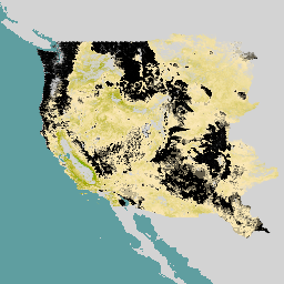
'The RCMAP (Rangeland Condition Monitoring Assessment and Projection) dataset quantifies the percent cover of rangeland components across western North America using Landsat imagery from 1985-2023. The RCMAP product suite consists of ten fractional components: annual herbaceous, bare ground, herbaceous, litter, non-sagebrush shrub, perennial herbaceous, sagebrush, shrub, tree, and shrub height in addition to the temporal trends of each component. Several enhancements were made to the RCMAP process relative to prior generations. First, high-resolution training was revised using an improved neural-net classifier and modelling approach. These data serve as foundation to the RCMAP approach. The training database was further improved by incorporating additional datasets. Next, the Landsat compositing approach was improved to better capture the range of conditions from across each year and through time. These composites are based on Collection 2 Landsat data with improved geolocation accuracy and dynamic range. Finally, the Canadian portion of the sagebrush biome was included, which expanded the study area by 29,199 km2.
Processing efficiency has been increased using open-source software and USGS High-Performance Computing (HPC) resources. The mapping area included eight regions which were subsequently mosaicked. These data can be used to answer critical questions regarding the influence of climate change and the suitability of management practices. Component products can be downloaded at Multi-Resolution Land Characteristics Consortium.
See also:
Rigge, M., H. Shi, C. Homer, P. Danielson, and B. Granneman. 2019. Long-term trajectories of fractional component change in the Northern Great Basin, USA. Ecosphere 10(6):e02762. doi:10.1002/ecs2.2762
Rigge, M., C. Homer, L. Cleeves, D. K. Meyer, B. Bunde, H. Shi, G. Xian, S. Schell, and M. Bobo. 2020. Quantifying western U.S. rangelands as fractional components with multi-resolution remote sensing and in situ data. Remote Sensing 12. doi:10.3390/rs12030412
Rigge, M., C. Homer, H. Shi, D. Meyer, B. Bunde, B. Granneman, K. Postma, P. Danielson, A. Case, and G. Xian. 2021. Rangeland Fractional Components Across the Western United States from 1985 to 2018. Remote Sensing 13:813. doi:10.3390/rs13040813.',
Bands
Bands
Pixel size: 30 meters (all bands)
| Name | Units | Min | Max | Pixel Size | Description |
|---|---|---|---|---|---|
rangeland_annual_herbaceous |
% | 0 | 100 | 30 meters | Percent of the pixel covered by annual herbaceous vegetation. |
rangeland_bare_ground |
% | 0 | 100 | 30 meters | Percent of the pixel covered by bare ground. |
rangeland_non_sagebrush_shrub |
% | 0 | 100 | 30 meters | Percent of the pixel covered by non-sagebrush shrubs. |
rangeland_herbaceous |
% | 0 | 100 | 30 meters | Percent of the pixel covered by herbaceous vegetation. |
rangeland_litter |
% | 0 | 100 | 30 meters | Percent of the pixel covered by litter. |
rangeland_sagebrush |
% | 0 | 100 | 30 meters | Percent of the pixel covered by sagebrush (Artemisia spp). |
rangeland_shrub |
% | 0 | 100 | 30 meters | Percent of the pixel covered by shrub. |
rangeland_shrub_height |
cm | 0 | 500 | 30 meters | Average height of shrubs in centimeters. |
rangeland_perennial_herbaceous |
% | 0 | 100 | 30 meters | Percent of the pixel covered by perennial herbaceous vegetation. |
rangeland_tree |
% | 0 | 100 | 30 meters | Percent of the pixel covered by tree. |
Terms of Use
Terms of Use
This work was authored as part of the Contributor's official duties as an Employee of the United States Government and is therefore a work of the United States Government. In accordance with 17 U.S.C. 105, no copyright protection is available for such works under U.S. Law. This is an Open Access article that has been identified as being free of known restrictions under copyright law, including all related and neighboring rights (https://creativecommons.org/publicdomain/mark/1.0/). You can copy, modify, distribute and perform the work, even for commercial purposes, all without asking permission.
Citations
Rigge, M.B., Bunde, B., Postma, K., and Shi, H., 2024, Rangeland Condition Monitoring Assessment and Projection (RCMAP) Fractional Component Time-Series Across the Western U.S. 1985-2023: U.S. Geological Survey data release, doi:10.5066/P9SJXUI1.
Explore with Earth Engine
Code Editor (JavaScript)
// Import the NLCD RCMAP collection.
var dataset = ee.ImageCollection('USGS/NLCD_RELEASES/2023_REL/RCMAP/V6/COVER');

// Filter the collection to the 2021 product.
var nlcd2021 = dataset.filter(ee.Filter.eq('system:index', '2021')).first();

// Each product has multiple bands for different rangeland categories.
print('Bands:', nlcd2021.bandNames());

// Select the rangeland_annual_herbaceous band.
var percentCover = nlcd2021.select('rangeland_annual_herbaceous');

var vis = {
  // Map 0..100.
  'palette': [
    '000000', 'f9e8b7', 'f7e3ac', 'f0dfa3', 'eedf9c', 'eada91', 'e8d687',
    'e0d281', 'ddd077', 'd6cc6d', 'd3c667', 'd0c55e', 'cfc555', 'c6bd4f',
    'c4ba46', 'bdb83a', 'bbb534', 'b7b02c', 'b0ad1f', 'adac17', 'aaaa0a',
    'a3a700', '9fa700', '9aa700', '92a700', '8fa700', '87a700', '85a700',
    '82aa00', '7aaa00', '77aa00', '70aa00', '6caa00', '67aa00', '5fa700',
    '57a700', '52a700', '4fa700', '4aa700', '42a700', '3ca700', '37a700',
    '37a300', '36a000', '369f00', '349d00', '339900', '339900', '2f9200',
    '2d9100', '2d8f00', '2c8a00', '2c8800', '2c8500', '2c8400', '2b8200',
    '297d00', '297a00', '297900', '277700', '247400', '247000', '29700f',
    '2c6d1c', '2d6d24', '336d2d', '366c39', '376c44', '396a4a', '396a55',
    '3a6a5f', '3a696a', '396774', '3a6782', '39668a', '376292', '34629f',
    '2f62ac', '2c5fb7', '245ec4', '1e5ed0', '115cdd', '005ae0', '0057dd',
    '0152d6', '0151d0', '014fcc', '014ac4', '0147bd', '0144b8', '0142b0',
    '0141ac', '013da7', '013aa0', '01399d', '013693', '013491', '012f8a',
    '012d85', '012c82', '01297a'
  ]
};

// Display the image on the map.
Map.setCenter(-114, 38, 6);
Map.addLayer(percentCover, vis, 'Rangeland Annual Herbaceous %');