Page Summary
-
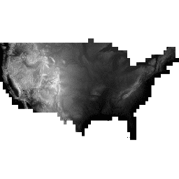
The National Elevation Dataset (NED) was the primary elevation data product of the USGS, now superseded by USGS/3DEP/10m_collection.
-
The NED is a seamless dataset providing the best available raster elevation data for the conterminous United States, parts of Alaska, Hawaii, and some territorial islands.
-
NED data is derived from diverse sources, processed to a common coordinate system and vertical measure, primarily referenced to NAD 83 and NAVD 88 over the conterminous United States.
-
The dataset contains a single band named 'elevation' with units in meters and a pixel size of 10.2 meters.
-
Most U.S. Geological Survey (USGS) information, including this dataset, resides in the public domain and can be used without restriction, with guidance available on crediting USGS as the source.
- Dataset Availability
- 2012-02-07T00:00:00Z–2012-02-07T00:00:00Z
- Dataset Producer
- United States Geological Survey
- Tags
Description
The National Elevation Dataset (NED) used to be* the primary elevation data product of the USGS. The NED is a seamless dataset with the best available raster elevation data of the conterminous United States, parts of Alaska, Hawaii, and some territorial islands. The NED is derived from diverse source data that are processed to a common coordinate system and unit of vertical measure. NED data are distributed in conformance with the North American Datum of 1983 (NAD 83). All elevation values are in meters and, over the conterminous United States, are referenced to the North American Vertical Datum of 1988 (NAVD 88). The vertical reference will vary in other areas.
*For over 15 years, the NED was the primary elevation data product of the USGS' National Map. However, it has been renamed and now considered just one component of elevation in The National Map after the 3D Elevation Program became operational.
Bands
Bands
Pixel size: 10.2 meters (all bands)
| Name | Units | Min | Max | Pixel Size | Description |
|---|---|---|---|---|---|
elevation |
m | -85.61* | 4414.22* | 10.2 meters | Elevation |
Terms of Use
Terms of Use
Most U.S. Geological Survey (USGS) information resides in the public domain and may be used without restriction. Additional information on Acknowledging or Crediting USGS as Information Source is available.
Citations
USGS National Elevation Dataset courtesy of the U.S. Geological Survey
Explore with Earth Engine
Code Editor (JavaScript)
var dataset = ee.Image('USGS/NED');
var elevation = dataset.select('elevation');
var elevationVis = {
  min: 0.0,
  max: 4000.0,
  gamma: 1.6,
};
Map.setCenter(-100.55, 40.71, 5);
Map.addLayer(elevation, elevationVis, 'Elevation');