Page Summary
-
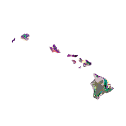
The dataset provides detailed vegetation and land cover classification for the Conterminous U.S., Alaska, Hawaii, and Puerto Rico.
-
Data for Hawaii and Puerto Rico represent the 2001 time-frame.
-
The classification scheme varies by region, using NatureServe's Ecological System Classification for Alaska and the lower 48 states, and island-specific systems for Puerto Rico and Hawaii.
-
The dataset has a pixel size of 30 meters with a single band for landcover class descriptions.
-
This USGS information is mostly in the public domain and can be used without restriction, with acknowledgement of the source encouraged.
- Dataset Availability
- 2001-01-01T00:00:00Z–2002-01-01T00:00:00Z
- Dataset Producer
- USGS
- Tags
Description
The GAP/LANDFIRE National Terrestrial Ecosystems data represents a detailed vegetation and land cover classification for the Conterminous U.S., Alaska, Hawaii, and Puerto Rico.GAP/LF 2011 Ecosystems for the Conterminous U.S. is an update of the National Gap Analysis Program Land Cover Data - Version 2.2. Alaska ecosystems have been updated by LANDFIRE to 2012 conditions (LANDFIRE 2012). Hawaii and Puerto Rico data represent the 2001 time-frame (Gon et al. 2006, Gould et al. 2008). The classification scheme used for the Alaska and the lower 48 states is based on NatureServe's Ecological System Classification (Comer et al. 2003), while Puerto Rico and Hawaii's map legend are based on island specific classification systems (Gon et al. 2006, Gould et al. 2008).
Bands
Bands
Pixel size: 30 meters (all bands)
| Name | Min | Max | Pixel Size | Description |
|---|---|---|---|---|
landcover |
1 | 9 | 30 meters | Landcover class descriptions |
landcover Class Table
| Value | Color | Description |
|---|---|---|
| 1 | #7c009c | Mixed Native-Alien Forest |
| 2 | #c14f00 | Mixed Native-Alien Shrubs and Grasses |
| 3 | #c1e09e | Native Coastal Vegetation |
| 4 | #ef0047 | Deschampsia Grassland |
| 5 | #d67900 | Aalii Shrubland |
| 6 | #00e3eb | Bog Vegetation |
| 7 | #ccbf70 | Native Dry Cliff Vegetation |
| 8 | #7c7047 | Native Shrubland / Sparse Ohia (native shrubs) |
| 9 | #617000 | Native Wet Cliff Vegetation |
| 10 | #66e805 | Open Mao Shrubland |
| 11 | #bf6b00 | Uluhe Shrubland |
| 12 | #9bcc9b | Closed Hala Forest |
| 13 | #008f99 | Closed Koa-Ohia Forest |
| 14 | #009c61 | Closed Ohia Forest |
| 15 | #2bcf56 | Closed Pouteria Forest (native trees) |
| 16 | #3ff2bf | Koa Forest |
| 17 | #9b9b4c | Mamane / Naio / Native Trees |
| 18 | #8ebc00 | Native Mesic to Dry Forest and Shrubland |
| 19 | #33c7a6 | Native Wet Forest and Shrubland |
| 20 | #7fbf00 | Ohia Forest |
| 21 | #007f7f | Olopua-Lama Forest |
| 22 | #b3ed7f | Open Koa-Mamane Forest |
| 23 | #21ab33 | Open Koa-Ohia Forest |
| 24 | #000000 | Open Ohia Forest |
| 25 | #002dc2 | Open Water |
| 26 | #afe200 | Wetland Vegetation |
| 27 | #fefec1 | Agriculture |
| 28 | #eb3642 | High Intensity Developed |
| 29 | #c94d42 | Low Intensity Developed |
| 30 | #ccb8bf | Alien Grassland |
| 31 | #9f298c | Alien Shrubland |
| 32 | #75009c | Alien Forest |
| 33 | #460075 | Kiawe Forest and Shrubland |
| 34 | #001493 | Uncharacterized Forest |
| 35 | #ededed | Uncharacterized Open-Sparse Vegetation |
| 36 | #d99485 | Uncharacterized Shrubland |
| 37 | #6b6b6b | Very Sparse Vegetation to Unvegetated |
Terms of Use
Terms of Use
Most U.S. Geological Survey (USGS) information resides in the public domain and may be used without restriction. Additional information on Acknowledging or Crediting USGS as Information Source is available.
Citations
Gon, S.M., A. Allison, R. J. Cannarella, J. D. Jacobi, K. Y. Kaneshiro, M. H. Kido, M. Lane-Kamehele, S. E. Miller. 2006. The Hawaii Gap Analysis Project Final Report. 487 pp.
Explore with Earth Engine
Code Editor (JavaScript)
var dataset = ee.Image('USGS/GAP/HI/2001');

var visualization = {
  bands: ['landcover'],
  min: 1.0,
  max: 37.0,
};

Map.setCenter(-157.0, 20.1, 7);

Map.addLayer(dataset, visualization, 'GAP Hawaii');