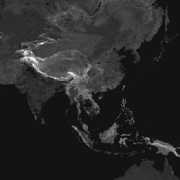
This global friction surface enumerates land-based travel
speed for all land pixels between 85 degrees north and 60 degrees
south for a nominal year 2015.
This map was produced through
a collaboration between the University of Oxford Malaria Atlas
Project (MAP), Google, the European Union Joint Research Centre
(JRC), and the University of Twente, Netherlands. The underlying
datasets used to produce the map include roads (comprising the
first ever global-scale use of Open Street Map and Google roads
datasets), railways, rivers, lakes, oceans, topographic conditions
(slope and elevation), landcover types, and national borders.
These datasets were each allocated a speed or speeds of travel in terms
of time to cross each pixel of that type. The datasets were then
combined to produce this “friction surface”, a map
where every pixel is allocated a nominal overall speed of travel
based on the types occurring within that pixel, with the fastest
travel mode intersecting the pixel being used to determine the
speed of travel in that pixel (with some exceptions such as national
boundaries, which have the effect of imposing a travel time penalty).
This map represents the travel speed from this allocation process, expressed
in units of minutes required to travel one meter. It forms the
underlying dataset behind the global accessibility map described
in the referenced paper.
'Source dataset credits are as described in the accompanying paper.
D.J. Weiss, A. Nelson, H.S. Gibson, W. Temperley, S. Peedell, A.
Lieber, M. Hancher, E. Poyart, S. Belchior, N. Fullman, B. Mappin,
U. Dalrymple, J. Rozier, T.C.D. Lucas, R.E. Howes, L.S. Tusting,
S.Y. Kang, E. Cameron, D. Bisanzio, K.E. Battle, S. Bhatt, and
P.W. Gething. A global map of travel time to cities to assess inequalities
in accessibility in 2015. Nature (2018).
doi:10.1038/nature25181
This global friction surface enumerates land-based travel speed for all land pixels between 85 degrees north and 60 degrees south for a nominal year 2015. This map was produced through a collaboration between the University of Oxford Malaria Atlas Project (MAP), Google, the European Union Joint Research Centre (JRC), and …
[[["Easy to understand","easyToUnderstand","thumb-up"],["Solved my problem","solvedMyProblem","thumb-up"],["Other","otherUp","thumb-up"]],[["Missing the information I need","missingTheInformationINeed","thumb-down"],["Too complicated / too many steps","tooComplicatedTooManySteps","thumb-down"],["Out of date","outOfDate","thumb-down"],["Samples / code issue","samplesCodeIssue","thumb-down"],["Other","otherDown","thumb-down"]],[],[[["\u003cp\u003eThis dataset, now superseded by a 2019 version, provides a global friction surface representing land-based travel speed for the year 2015.\u003c/p\u003e\n"],["\u003cp\u003eThe friction surface, expressed in minutes required to travel one meter, covers land pixels between 85 degrees north and 60 degrees south.\u003c/p\u003e\n"],["\u003cp\u003eIt was developed by the University of Oxford Malaria Atlas Project (MAP), Google, the European Union Joint Research Centre (JRC), and the University of Twente.\u003c/p\u003e\n"],["\u003cp\u003eVarious datasets including roads, railways, rivers, topography, and landcover were used to determine the overall travel speed for each pixel.\u003c/p\u003e\n"],["\u003cp\u003eThe friction surface serves as the foundation for a global accessibility map, detailed in the cited Nature paper.\u003c/p\u003e\n"]]],["This dataset provides a global \"friction surface\" map for 2015, showing land-based travel speed in minutes per meter for each land pixel between 85°N and 60°S. The data, produced by a collaboration, combines information from roads, railways, rivers, topography, land cover, and borders to calculate nominal travel speeds. Each pixel's speed is based on the fastest travel mode intersecting it. The dataset is accessible via Earth Engine with a provided code snippet and is licensed under Creative Commons Attribution 4.0.\n"],null,["**Caution:** This dataset has been superseded by [Oxford/MAP/friction_surface_2019](/earth-engine/datasets/catalog/Oxford_MAP_friction_surface_2019). \n\nDataset Availability\n: 2015-01-01T00:00:00Z--2016-01-01T00:00:00Z\n\nDataset Provider\n:\n\n\n [Malaria Atlas Project](https://malariaatlas.org/research-project/accessibility-to-cities/)\n\nTags\n:\n accessibility \n friction \n jrc \n map \n oxford \n population \ntwente \n\nDescription \nThis global friction surface enumerates land-based travel\nspeed for all land pixels between 85 degrees north and 60 degrees\nsouth for a nominal year 2015.\n\nThis map was produced through\na collaboration between the University of Oxford Malaria Atlas\nProject (MAP), Google, the European Union Joint Research Centre\n(JRC), and the University of Twente, Netherlands. The underlying\ndatasets used to produce the map include roads (comprising the\nfirst ever global-scale use of Open Street Map and Google roads\ndatasets), railways, rivers, lakes, oceans, topographic conditions\n(slope and elevation), landcover types, and national borders.\n\nThese datasets were each allocated a speed or speeds of travel in terms\nof time to cross each pixel of that type. The datasets were then\ncombined to produce this \"friction surface\", a map\nwhere every pixel is allocated a nominal overall speed of travel\nbased on the types occurring within that pixel, with the fastest\ntravel mode intersecting the pixel being used to determine the\nspeed of travel in that pixel (with some exceptions such as national\nboundaries, which have the effect of imposing a travel time penalty).\n\nThis map represents the travel speed from this allocation process, expressed\nin units of minutes required to travel one meter. It forms the\nunderlying dataset behind the global accessibility map described\nin the referenced paper.\n\n'Source dataset credits are as described in the accompanying paper.\n\nBands\n\n**Bands**\n\n| Name | Units | Min | Max | Pixel Size | Description |\n|------------|---------------|--------|---------|------------|--------------------------|\n| `friction` | minutes/meter | 0.0005 | 87.3075 | | Land-based travel speed. |\n\nTerms of Use\n\n**Terms of Use**\n\nThis work is licensed under a [Creative Commons Attribution\n4.0 International License](https://creativecommons.org/licenses/by/4.0/).\n\nCitations \nCitations:\n\n- D.J. Weiss, A. Nelson, H.S. Gibson, W. Temperley, S. Peedell, A.\n Lieber, M. Hancher, E. Poyart, S. Belchior, N. Fullman, B. Mappin,\n U. Dalrymple, J. Rozier, T.C.D. Lucas, R.E. Howes, L.S. Tusting,\n S.Y. Kang, E. Cameron, D. Bisanzio, K.E. Battle, S. Bhatt, and\n P.W. Gething. A global map of travel time to cities to assess inequalities\n in accessibility in 2015. Nature (2018).\n [doi:10.1038/nature25181](https://doi.org/10.1038/nature25181)\n\nExplore with Earth Engine **Important:** Earth Engine is a platform for petabyte-scale scientific analysis and visualization of geospatial datasets, both for public benefit and for business and government users. Earth Engine is free to use for research, education, and nonprofit use. To get started, please [register for Earth Engine access.](https://console.cloud.google.com/earth-engine)\n\nCode Editor (JavaScript) \n\n```javascript\nvar dataset = ee.Image('Oxford/MAP/friction_surface_2015_v1_0');\nvar landBasedTravelSpeed = dataset.select('friction');\nvar visParams = {\n min: 0.0022,\n max: 0.04,\n palette: [\n '313695', '4575b4', '74add1', 'abd9e9', 'e0f3f8', 'ffffbf', 'fee090',\n 'fdae61', 'f46d43', 'd73027', 'a50026'\n ],\n};\nMap.setCenter(43.55, 36.98, 4);\nMap.addLayer(landBasedTravelSpeed, visParams, 'Land-based travel speed');\n```\n[Open in Code Editor](https://code.earthengine.google.com/?scriptPath=Examples:Datasets/Oxford/Oxford_MAP_friction_surface_2015_v1_0) \n[Global Friction Surface 2015 \\[deprecated\\]](/earth-engine/datasets/catalog/Oxford_MAP_friction_surface_2015_v1_0) \nThis global friction surface enumerates land-based travel speed for all land pixels between 85 degrees north and 60 degrees south for a nominal year 2015. This map was produced through a collaboration between the University of Oxford Malaria Atlas Project (MAP), Google, the European Union Joint Research Centre (JRC), and ... \nOxford/MAP/friction_surface_2015_v1_0, accessibility,jrc,map,oxford,population,twente \n2015-01-01T00:00:00Z/2016-01-01T00:00:00Z \n-60 -180 85 180 \nGoogle Earth Engine \nhttps://developers.google.com/earth-engine/datasets\n\n- [](https://doi.org/https://malariaatlas.org/research-project/accessibility-to-cities/)\n- [](https://doi.org/https://developers.google.com/earth-engine/datasets/catalog/Oxford_MAP_friction_surface_2015_v1_0)"]]