Page Summary
-
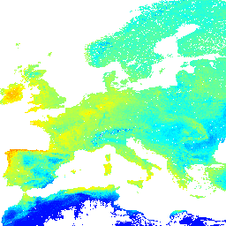
This dataset provides the potential natural vegetation FAPAR predicted monthly median based on PROB-V FAPAR from 2014-2017.
-
The dataset has a pixel size of 1000 meters and includes monthly bands for January through December, plus annual and annual difference bands.
-
It is available from 2001-01-01T00:00:00Z to 2002-01-01T00:00:00Z and is provided by EnvirometriX Ltd.
-
The dataset is licensed under the Creative Commons Attribution-ShareAlike 4.0 International License.
- Dataset Availability
- 2001-01-01T00:00:00Z–2002-01-01T00:00:00Z
- Dataset Producer
- EnvirometriX Ltd
- Tags
Description
Potential Natural Vegetation FAPAR predicted monthly median (based on PROB-V FAPAR 2014-2017). Description.
To access and visualize maps outside of Earth Engine, use this page.
If you discover a bug, artifact or inconsistency in the LandGIS maps or if you have a question please use the following channels:
Bands
Bands
Pixel size: 1000 meters (all bands)
| Name | Units | Min | Max | Pixel Size | Description |
|---|---|---|---|---|---|
jan |
Fraction | 0* | 220* | 1000 meters | Jan Potential FAPAR monthly |
feb |
Fraction | 0* | 220* | 1000 meters | Feb Potential FAPAR monthly |
mar |
Fraction | 0* | 220* | 1000 meters | Mar Potential FAPAR monthly |
apr |
Fraction | 0* | 220* | 1000 meters | Apr Potential FAPAR monthly |
may |
Fraction | 0* | 220* | 1000 meters | May Potential FAPAR monthly |
jun |
Fraction | 0* | 220* | 1000 meters | Jun Potential FAPAR monthly |
jul |
Fraction | 0* | 220* | 1000 meters | Jul Potential FAPAR monthly |
aug |
Fraction | 0* | 220* | 1000 meters | Aug Potential FAPAR monthly |
sep |
Fraction | 0* | 220* | 1000 meters | Sep Potential FAPAR monthly |
oct |
Fraction | 0* | 220* | 1000 meters | Oct Potential FAPAR monthly |
nov |
Fraction | 0* | 220* | 1000 meters | Nov Potential FAPAR monthly |
dec |
Fraction | 0* | 220* | 1000 meters | Dec Potential FAPAR monthly |
annual |
Fraction | 0* | 220* | 1000 meters | Anuual Potential FAPAR monthly |
annualdiff |
Fraction | 0* | 220* | 1000 meters | Annual Difference Potential FAPAR monthly |
Terms of Use
Terms of Use
This is a human-readable summary of (and not a substitute for) the license.
You are free to - Share - copy and redistribute the material in any medium or format Adapt - remix, transform, and build upon the material for any purpose, even commercially.
This license is acceptable for Free Cultural Works. The licensor cannot revoke these freedoms as long as you follow the license terms.
Under the following terms - Attribution - You must give appropriate credit, provide a link to the license, and indicate if changes were made. You may do so in any reasonable manner, but not in any way that suggests the licensor endorses you or your use.
ShareAlike - If you remix, transform, or build upon the material, you must distribute your contributions under the same license as the original.
No additional restrictions - You may not apply legal terms or technological measures that legally restrict others from doing anything the license permits.
Citations
Hengl T, Walsh MG, Sanderman J, Wheeler I, Harrison SP, Prentice IC. (2018) Global Mapping of Potential Natural Vegetation: An Assessment of Machine Learning Algorithms for Estimating Land Potential. PeerJ Preprints. 10.7287/peerj.preprints.26811v5
DOIs
Explore with Earth Engine
Code Editor (JavaScript)
var dataset = ee.Image('OpenLandMap/PNV/PNV_FAPAR_PROBA-V_D/v01');

var visualization = {
  bands: ['jan'],
  min: 0.0,
  max: 220.0,
  palette: ['0000ff', '00ffff', 'ffff00', 'ff0000']
};

Map.centerObject(dataset);

Map.addLayer(dataset, visualization, 'Potential FAPAR monthly');