Atmosphere-Land Exchange Inverse / Disaggregation of the Atmosphere-Land
Exchange Inverse (ALEXI/DisALEXI)
DisALEXI was recently ported to Google Earth Engine as part of the OpenET
framework and the baseline ALEXI/DisALEXI model structure is described by
Anderson et al. (2012, 2018). The ALEXI evapotranspiration (ET) model
specifically uses time differential land surface temperature (LST)
measurements from geostationary or moderate resolution polar orbiting
platforms to generate regional ET maps. DisALEXI then disaggregates the
regional ALEXI ET to finer scales using Landsat data (30 m; biweekly) to
resolve individual farm fields and other landscape features.
Additional information
Bands
Pixel Size 30 meters
Bands
Name
Units
Pixel Size
Description
et
mm
meters
DisALEXI ET value
count
count
meters
Number of cloud free values
Image Properties
Image Properties
Name
Type
Description
build_date
STRING
Date assets were built
cloud_cover_max
DOUBLE
Maximum CLOUD_COVER_LAND percent value for Landsat images included in interpolation
collections
STRING
List of Landsat collections for Landsat images included in the interpolation
core_version
STRING
OpenET core library version
end_date
STRING
End date of month
et_reference_band
STRING
Band in et_reference_source that contains the daily reference ET data
et_reference_resample
STRING
Spatial interpolation mode to resample daily reference ET data
et_reference_source
STRING
Collection ID for the daily reference ET data
interp_days
DOUBLE
Maximum number of days before and after each image date to include in interpolation
interp_method
STRING
Method used to interpolate between Landsat model estimates
interp_source_count
DOUBLE
Number of available images in the interpolation source image collection for the target month
mgrs_tile
STRING
MGRS grid zone ID
model_name
STRING
OpenET model name
model_version
STRING
OpenET model version
scale_factor_count
DOUBLE
Scaling factor that should be applied to the count band
scale_factor_et
DOUBLE
Scaling factor that should be applied to the et band
Anderson, M., Gao, F., Knipper, K., Hain, C., Dulaney, W., Baldocchi, D .,
Eichelmann, E., Hemes, K., Yang, Y., Medellin-Azuara, J. and Kustas, W.,
2018. Field-scale assessment of land and water use change over the
California Delta using remote sensing. Remote Sensing, 10(6), p.889.
doi:10.3390/rs10060889
Anderson, M.C., Norman, J.M., Mecikalski, J.R., Otkin, J.A. and Kustas,
W.P., 2007. A climatological study of evapotranspiration and moisture
stress across the continental United States based on thermal remote
sensing: 1. Model formulation. Journal of Geophysical Research:
Atmospheres, 112(D10).
doi:10.1029/2006JD007506
Atmosphere-Land Exchange Inverse / Disaggregation of the Atmosphere-Land Exchange Inverse (ALEXI/DisALEXI) DisALEXI was recently ported to Google Earth Engine as part of the OpenET framework and the baseline ALEXI/DisALEXI model structure is described by Anderson et al. (2012, 2018). The ALEXI evapotranspiration (ET) model specifically uses time differential land surface …
[[["Easy to understand","easyToUnderstand","thumb-up"],["Solved my problem","solvedMyProblem","thumb-up"],["Other","otherUp","thumb-up"]],[["Missing the information I need","missingTheInformationINeed","thumb-down"],["Too complicated / too many steps","tooComplicatedTooManySteps","thumb-down"],["Out of date","outOfDate","thumb-down"],["Samples / code issue","samplesCodeIssue","thumb-down"],["Other","otherDown","thumb-down"]],[],[[["\u003cp\u003eThe OpenET DisALEXI dataset provides monthly evapotranspiration (ET) data for the contiguous United States (CONUS) at a 30-meter resolution, derived from Landsat and GRIDMET data.\u003c/p\u003e\n"],["\u003cp\u003eDisALEXI, part of the OpenET framework, uses a model based on land surface temperature changes to estimate ET and is further disaggregated using Landsat for finer-scale detail.\u003c/p\u003e\n"],["\u003cp\u003eData is available from January 2008 to December 2023 and is provided by OpenET, Inc.under a CC-BY-4.0 license.\u003c/p\u003e\n"],["\u003cp\u003eThe dataset includes two bands: 'et' representing the DisALEXI ET value in millimeters and 'count' indicating the number of cloud-free values used in the calculation.\u003c/p\u003e\n"],["\u003cp\u003eUsers can explore and analyze this dataset within Google Earth Engine for research, education, and non-profit purposes.\u003c/p\u003e\n"]]],["The OpenET DisALEXI dataset, available from 2001-01-01 to 2023-12-01, provides monthly evapotranspiration (ET) data at a 30-meter resolution. It uses the ALEXI/DisALEXI model, which combines land surface temperature data with Landsat data to estimate ET, including a band with the 'et' value and a 'count' of cloud-free observations. The data can be accessed via Earth Engine using a provided code snippet and is licenced with a CC-BY-4.0 use license.\n"],null,["Dataset Availability\n: 2001-01-01T00:00:00Z--2024-12-01T00:00:00Z\n\nDataset Provider\n:\n\n\n [OpenET, Inc.](https://openetdata.org/)\n\nCadence\n: 1 Month\n\nTags\n:\n[evapotranspiration](/earth-engine/datasets/tags/evapotranspiration) [gridmet-derived](/earth-engine/datasets/tags/gridmet-derived) [landsat-derived](/earth-engine/datasets/tags/landsat-derived) [monthly](/earth-engine/datasets/tags/monthly) [openet](/earth-engine/datasets/tags/openet) [water](/earth-engine/datasets/tags/water) [water-vapor](/earth-engine/datasets/tags/water-vapor) \n\nDescription \nAtmosphere-Land Exchange Inverse / Disaggregation of the Atmosphere-Land\nExchange Inverse (ALEXI/DisALEXI)\n\nDisALEXI was recently ported to Google Earth Engine as part of the OpenET\nframework and the baseline ALEXI/DisALEXI model structure is described by\nAnderson et al. (2012, 2018). The ALEXI evapotranspiration (ET) model\nspecifically uses time differential land surface temperature (LST)\nmeasurements from geostationary or moderate resolution polar orbiting\nplatforms to generate regional ET maps. DisALEXI then disaggregates the\nregional ALEXI ET to finer scales using Landsat data (30 m; biweekly) to\nresolve individual farm fields and other landscape features.\n[Additional information](https://openetdata.org/methodologies/)\n\nBands\n\n\n**Pixel Size**\n\n30 meters\n\n**Bands**\n\n| Name | Units | Description |\n|---------|-------|-----------------------------|\n| `et` | mm | DisALEXI ET value |\n| `count` | count | Number of cloud free values |\n\nImage Properties\n\n**Image Properties**\n\n| Name | Type | Description |\n|-----------------------|--------|----------------------------------------------------------------------------------------------|\n| build_date | STRING | Date assets were built |\n| cloud_cover_max | DOUBLE | Maximum CLOUD_COVER_LAND percent value for Landsat images included in interpolation |\n| collections | STRING | List of Landsat collections for Landsat images included in the interpolation |\n| core_version | STRING | OpenET core library version |\n| end_date | STRING | End date of month |\n| et_reference_band | STRING | Band in et_reference_source that contains the daily reference ET data |\n| et_reference_resample | STRING | Spatial interpolation mode to resample daily reference ET data |\n| et_reference_source | STRING | Collection ID for the daily reference ET data |\n| interp_days | DOUBLE | Maximum number of days before and after each image date to include in interpolation |\n| interp_method | STRING | Method used to interpolate between Landsat model estimates |\n| interp_source_count | DOUBLE | Number of available images in the interpolation source image collection for the target month |\n| mgrs_tile | STRING | MGRS grid zone ID |\n| model_name | STRING | OpenET model name |\n| model_version | STRING | OpenET model version |\n| scale_factor_count | DOUBLE | Scaling factor that should be applied to the count band |\n| scale_factor_et | DOUBLE | Scaling factor that should be applied to the et band |\n| start_date | STRING | Start date of month |\n\nTerms of Use\n\n**Terms of Use**\n\n[CC-BY-4.0](https://spdx.org/licenses/CC-BY-4.0.html)\n\nCitations \nCitations:\n\n- Anderson, M., Gao, F., Knipper, K., Hain, C., Dulaney, W., Baldocchi, D .,\n Eichelmann, E., Hemes, K., Yang, Y., Medellin-Azuara, J. and Kustas, W.,\n 2018. Field-scale assessment of land and water use change over the\n California Delta using remote sensing. Remote Sensing, 10(6), p.889.\n [doi:10.3390/rs10060889](https://doi.org/10.3390/rs10060889)\n- Anderson, M.C., Norman, J.M., Mecikalski, J.R., Otkin, J.A. and Kustas,\n W.P., 2007. A climatological study of evapotranspiration and moisture\n stress across the continental United States based on thermal remote\n sensing: 1. Model formulation. Journal of Geophysical Research:\n Atmospheres, 112(D10).\n [doi:10.1029/2006JD007506](https://doi.org/10.1029/2006JD007506)\n\nDOIs\n\n- \u003chttps://doi.org/10.3390/rs10060889\u003e\n\nExplore with Earth Engine **Important:** Earth Engine is a platform for petabyte-scale scientific analysis and visualization of geospatial datasets, both for public benefit and for business and government users. Earth Engine is free to use for research, education, and nonprofit use. To get started, please [register for Earth Engine access.](https://console.cloud.google.com/earth-engine)\n\nCode Editor (JavaScript) \n\n```javascript\n
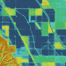
var dataset = ee.ImageCollection('OpenET/DISALEXI/CONUS/GRIDMET/MONTHLY/v2_0')\n .filterDate('2020-01-01', '2021-01-01');\n\n// Compute the annual evapotranspiration (ET) as the sum of the monthly ET\n// images for the year.\nvar et = dataset.select('et').sum();\n\nvar visualization = {\n min: 0,\n max: 1400,\n palette: [\n '9e6212', 'ac7d1d', 'ba9829', 'c8b434', 'd6cf40', 'bed44b', '9fcb51',\n '80c256', '61b95c', '42b062', '45b677', '49bc8d', '4dc2a2', '51c8b8',\n '55cece', '4db4ba', '459aa7', '3d8094', '356681', '2d4c6e',\n ]\n};\n\nMap.setCenter(-100, 38, 5);\n\nMap.addLayer(et, visualization, 'OpenET DisALEXI Annual ET');\n```\n[Open in Code Editor](https://code.earthengine.google.com/?scriptPath=Examples:Datasets/OpenET/OpenET_DISALEXI_CONUS_GRIDMET_MONTHLY_v2_0) \n[OpenET DisALEXI Monthly Evapotranspiration v2.0](/earth-engine/datasets/catalog/OpenET_DISALEXI_CONUS_GRIDMET_MONTHLY_v2_0) \nAtmosphere-Land Exchange Inverse / Disaggregation of the Atmosphere-Land Exchange Inverse (ALEXI/DisALEXI) DisALEXI was recently ported to Google Earth Engine as part of the OpenET framework and the baseline ALEXI/DisALEXI model structure is described by Anderson et al. (2012, 2018). The ALEXI evapotranspiration (ET) model specifically uses time differential land surface ... \nOpenET/DISALEXI/CONUS/GRIDMET/MONTHLY/v2_0, evapotranspiration,gridmet-derived,landsat-derived,monthly,openet,water,water-vapor \n2001-01-01T00:00:00Z/2024-12-01T00:00:00Z \n25 -126 50 -66 \nGoogle Earth Engine \nhttps://developers.google.com/earth-engine/datasets\n\n- [https://doi.org/10.3390/rs10060889](https://doi.org/https://openetdata.org/)\n- [https://doi.org/10.3390/rs10060889](https://doi.org/https://developers.google.com/earth-engine/datasets/catalog/OpenET_DISALEXI_CONUS_GRIDMET_MONTHLY_v2_0)"]]