The NASA-USDA Enhanced SMAP Global soil moisture data provides soil moisture information across
the globe at 10-km spatial resolution. This dataset includes: surface,
subsurface, soil moisture (mm), soil moisture profile (%),
surface and subsurface soil moisture anomalies (-).
The dataset is generated by integrating satellite-derived Soil Moisture Active Passive (SMAP)
Level 3 soil moisture observations into the modified two-layer Palmer model using a 1-D
Ensemble Kalman Filter (EnKF) data assimilation approach.
Soil moisture anomalies were computed from the climatology of the day of interest.
The climatology was estimated based on the full data record of the SMAP satellite observation
and the 31-day-centered moving-window approach. The assimilation of the SMAP soil moisture
observations help improve the model-based soil moisture predictions particularly over poorly
instrumented areas of the world that lack good quality precipitation data.
This dataset was developed by the Hydrological Science Laboratory at NASA's Goddard Space
Flight Center in cooperation with USDA Foreign Agricultural Services and USDA Hydrology
and Remote Sensing Lab.
Sazib, N., J. D. Bolten, and I. E. Mladenova. 2021.
Leveraging NASA Soil Moisture Active Passive for Assessing Fire
Susceptibility and Potential Impacts Over Australia and California.
IEEE Journal of Selected Topics in Applied Earth Observations and
Remote Sensing, 15: 779-787.
doi:10.1109/jstars.2021.3136756
Mladenova, I.E., Bolten, J.D., Crow, W., Sazib, N. and Reynolds, C., 2020.
Agricultural drought monitoring via the assimilation of SMAP soil moisture retrievals into a
global soil water balance model. Front. Big Data,
3(10).
doi:10.3389/fdata.2020.00010
Sazib, N., J. D. Bolten, and I. E. Mladenova. 2021.
Leveraging NASA Soil Moisture Active Passive for Assessing Fire
Susceptibility and Potential Impacts Over Australia and California.
IEEE Journal of Selected Topics in Applied Earth Observations and
Remote Sensing, 15: 779-787.
doi:10.1109/jstars.2021.3136756
Mladenova, I.E., Bolten, J.D., Crow, W.T., Sazib, N., Cosh, M.H., Tucker, C.J. and Reynolds,
C., 2019.
Evaluating the operational application of SMAP for global agricultural drought monitoring.
IEEE Journal of Selected Topics in Applied Earth Observations and Remote Sensing,
12(9): 3387-3397.
doi:10.1109/JSTARS.2019.2923555
Sazib, N., Mladenova, I., & Bolten, J. (2020).
Assessing the Impact of ENSO on Agriculture over Africa using Earth Observation Data.
Frontiers in Sustainable Food Systems, 4, 188.
doi:10.3389/fsufs.2020.509914Google Scholar
Sazib, N., Mladenova, I. and Bolten, J., 2018.
Leveraging the google earth engine for drought assessment using global soil moisture data.
Remote sensing,
10(8): 1265.
doi:10.3390/rs10081265
Bolten, J., W.T. Crow, X. Zhan, T.J. Jackson, and C.A. Reynolds (2010).
Evaluating the Utility of Remotely Sensed Soil Moisture Retrievals for Operational Agricultural
Drought Monitoring, IEEE Transactions on Geoscience and Remote Sensing,
3(1): 57-66.
doi:10.1109/JSTARS.2009.2037163Google Scholar
Bolten, J., and W. T. Crow (2012).
Improved prediction of quasi-global vegetation conditions using remotely sensed surface soil
moisture, Geophysical Research Letters,
39: (L19406).
[doi:10.1029/2012GL053470][https://doi.org/10.1029/2012GL053470)
Google Scholar
Entekhabi, D, Njoku, EG, O'Neill, PE, Kellogg, KH, Crow, WT, Edelstein,
WN, Entin, JK, Goodman, SD, Jackson, TJ, Johnson, J, Kimball, J, Piepmeier,
JR, Koster, RD, Martin, N, McDonald, KC, Moghaddam, M, Moran, S, Reichle,
R, Shi, JC, Spencer, MW, Thurman, SW, Tsang, L & Van Zyl, J (2010).
The soil moisture active passive (SMAP) mission, Proceedings of the IEEE,
98(5): 704-716.
doi:10.1109/JPROC.2010.2043918
I. E. Mladenova, J.D. Bolten, W.T. Crow, M.C. Anderson, C.R. Hain, D.M. Johnson, R. Mueller
(2017). Intercomparison of Soil Moisture, Evaporative Stress, and Vegetation Indices for
Estimating Corn and Soybean Yields Over the U.S.,
IEEE Journal of Selected Topics in Applied Earth Observations and Remote Sensing,
10(4): 1328-1343.
doi:10.1109/JSTARS.2016.2639338
O'Neill, P. E., S. Chan, E. G. Njoku, T. Jackson, and R. Bindlish
(2016).
SMAP L3 Radiometer Global Daily 36 km EASE-Grid Soil Moisture, Version 4.
Boulder, Colorado USA. NASA National Snow and Ice Data Center Distributed
Active Archive Center.doi:10.5067/ZX7YX2Y2LHEB
The NASA-USDA Enhanced SMAP Global soil moisture data provides soil moisture information across the globe at 10-km spatial resolution. This dataset includes: surface, subsurface, soil moisture (mm), soil moisture profile (%), surface and subsurface soil moisture anomalies (-). The dataset is generated by integrating satellite-derived Soil Moisture Active Passive (SMAP) …
[[["Easy to understand","easyToUnderstand","thumb-up"],["Solved my problem","solvedMyProblem","thumb-up"],["Other","otherUp","thumb-up"]],[["Missing the information I need","missingTheInformationINeed","thumb-down"],["Too complicated / too many steps","tooComplicatedTooManySteps","thumb-down"],["Out of date","outOfDate","thumb-down"],["Samples / code issue","samplesCodeIssue","thumb-down"],["Other","otherDown","thumb-down"]],[],[[["\u003cp\u003eThis dataset has been superseded by a newer version, NASA/SMAP/SPL4SMGP/007.\u003c/p\u003e\n"],["\u003cp\u003eThe NASA-USDA Enhanced SMAP dataset provides global soil moisture information at 10-km resolution, including surface and subsurface measurements, anomalies, and soil moisture profiles.\u003c/p\u003e\n"],["\u003cp\u003eIt covers the period from April 2, 2015, to August 2, 2022, and is generated by integrating SMAP satellite observations into a hydrological model.\u003c/p\u003e\n"],["\u003cp\u003eThis dataset is in the public domain and available without restriction.\u003c/p\u003e\n"],["\u003cp\u003eThe dataset was developed by NASA's Goddard Space Flight Center in cooperation with USDA Foreign Agricultural Services and USDA Hydrology and Remote Sensing Lab.\u003c/p\u003e\n"]]],["This dataset provides global soil moisture data at a 10-km resolution from 2015-04-02 to 2022-08-02, derived from NASA's SMAP satellite. It offers surface and subsurface soil moisture in mm, soil moisture profiles in percentage, and soil moisture anomalies, generated using a data assimilation approach. The information is accessible through Earth Engine, using the `ee.ImageCollection(\"NASA_USDA/HSL/SMAP10KM_soil_moisture\")` code, and it is publicly available without usage restrictions. However, it has been superseded by a new dataset: NASA/SMAP/SPL4SMGP/007.\n"],null,["# NASA-USDA Enhanced SMAP Global Soil Moisture Data [deprecated]\n\n**Caution:** This dataset has been superseded by [NASA/SMAP/SPL4SMGP/007](/earth-engine/datasets/catalog/NASA_SMAP_SPL4SMGP_007). \n\nDataset Availability\n: 2015-04-02T12:00:00Z--2022-08-02T12:00:00Z\n\nDataset Provider\n:\n\n\n [NASA GSFC](https://doi.org/10.1109/jstars.2021.3136756)\n\nCadence\n: 3 Days\n\nTags\n:\n geophysical \n hsl \n nasa \n smap \n soil \n soil-moisture \nusda \n\n#### Description\n\nThe NASA-USDA Enhanced SMAP Global soil moisture data provides soil moisture information across\nthe globe at 10-km spatial resolution. This dataset includes: surface,\nsubsurface, soil moisture (mm), soil moisture profile (%),\nsurface and subsurface soil moisture anomalies (-).\n\nThe dataset is generated by integrating satellite-derived Soil Moisture Active Passive (SMAP)\nLevel 3 soil moisture observations into the modified two-layer Palmer model using a 1-D\nEnsemble Kalman Filter (EnKF) data assimilation approach.\nSoil moisture anomalies were computed from the climatology of the day of interest.\nThe climatology was estimated based on the full data record of the SMAP satellite observation\nand the 31-day-centered moving-window approach. The assimilation of the SMAP soil moisture\nobservations help improve the model-based soil moisture predictions particularly over poorly\ninstrumented areas of the world that lack good quality precipitation data.\n\nThis dataset was developed by the Hydrological Science Laboratory at NASA's Goddard Space\nFlight Center in cooperation with USDA Foreign Agricultural Services and USDA Hydrology\nand Remote Sensing Lab.\n\n### Bands\n\n\n**Pixel Size**\n\n10000 meters\n\n**Bands**\n\n| Name | Units | Min | Max | Pixel Size | Description |\n|---------|---------------|------|---------|------------|----------------------------------|\n| `ssm` | mm | 0\\* | 25.39\\* | meters | Surface soil moisture |\n| `susm` | mm | 0\\* | 274.6\\* | meters | Subsurface soil moisture |\n| `smp` | Fraction | 0\\* | 1\\* | meters | Soil moisture profile |\n| `ssma` | Dimensionless | -4\\* | 4\\* | meters | Surface soil moisture anomaly |\n| `susma` | Dimensionless | -4\\* | 4\\* | meters | Subsurface soil moisture anomaly |\n\n\\* estimated min or max value\n\n### Terms of Use\n\n**Terms of Use**\n\nThis dataset is in the public domain and is available\nwithout restriction on use and distribution. See [NASA's\nEarth Science Data \\& Information Policy](https://www.earthdata.nasa.gov/engage/open-data-services-and-software/data-and-information-policy)\nfor additional information.\n\n### Citations\n\nCitations:\n\n- **Sazib, N., J. D. Bolten, and I. E. Mladenova. 2021.**\n Leveraging NASA Soil Moisture Active Passive for Assessing Fire\n Susceptibility and Potential Impacts Over Australia and California.\n *IEEE Journal of Selected Topics in Applied Earth Observations and\n Remote Sensing* , 15: 779-787.\n [doi:10.1109/jstars.2021.3136756](https://doi.org/10.1109/jstars.2021.3136756)\n\n **Mladenova, I.E., Bolten, J.D., Crow, W., Sazib, N. and Reynolds, C., 2020.**\n Agricultural drought monitoring via the assimilation of SMAP soil moisture retrievals into a\n global soil water balance model. *Front. Big Data* ,\n 3(10).\n [doi:10.3389/fdata.2020.00010](https://doi.org/10.3389/fdata.2020.00010)\n- **Sazib, N., J. D. Bolten, and I. E. Mladenova. 2021.**\n Leveraging NASA Soil Moisture Active Passive for Assessing Fire\n Susceptibility and Potential Impacts Over Australia and California.\n *IEEE Journal of Selected Topics in Applied Earth Observations and\n Remote Sensing* , 15: 779-787.\n [doi:10.1109/jstars.2021.3136756](https://doi.org/10.1109/jstars.2021.3136756)\n- **Mladenova, I.E., Bolten, J.D., Crow, W.T., Sazib, N., Cosh, M.H., Tucker, C.J. and Reynolds,\n C., 2019.**\n Evaluating the operational application of SMAP for global agricultural drought monitoring.\n *IEEE Journal of Selected Topics in Applied Earth Observations and Remote Sensing* ,\n 12(9): 3387-3397.\n [doi:10.1109/JSTARS.2019.2923555](https://doi.org/10.1109/JSTARS.2019.2923555)\n- **Sazib, N., Mladenova, I., \\& Bolten, J. (2020).**\n Assessing the Impact of ENSO on Agriculture over Africa using Earth Observation Data.\n *Frontiers in Sustainable Food Systems* , 4, 188.\n [doi:10.3389/fsufs.2020.509914](https://doi.org/10.3389/fsufs.2020.509914)\n [Google Scholar](https://scholar.google.com/scholar?cluster=10102210156681705582&oi=scholarr)\n- **Sazib, N., Mladenova, I. and Bolten, J., 2018.**\n Leveraging the google earth engine for drought assessment using global soil moisture data.\n *Remote sensing* ,\n 10(8): 1265.\n [doi:10.3390/rs10081265](https://doi.org/10.3390/rs10081265)\n- **Bolten, J., W.T. Crow, X. Zhan, T.J. Jackson, and C.A. Reynolds (2010).**\n Evaluating the Utility of Remotely Sensed Soil Moisture Retrievals for Operational Agricultural\n Drought Monitoring, *IEEE Transactions on Geoscience and Remote Sensing* ,\n 3(1): 57-66.\n [doi:10.1109/JSTARS.2009.2037163](https://doi.org/10.1109/JSTARS.2009.2037163)\n [Google Scholar](https://scholar.google.com/scholar?as_sdt=0%2C21&q=Improved+prediction+of+quasi-global+vegetation+conditions+using+remotely-sensed+surface+soil+moisture%2C+&btnG=)\n- **Bolten, J., and W. T. Crow (2012).**\n Improved prediction of quasi-global vegetation conditions using remotely sensed surface soil\n moisture, *Geophysical Research Letters* ,\n 39: (L19406).\n \\[doi:10.1029/2012GL053470\\]\\[https://doi.org/10.1029/2012GL053470)\n [Google Scholar](https://scholar.google.com/scholar?as_sdt=0%2C21&q=Improved+prediction+of+quasi-global+vegetation+conditions+using+remotely-sensed+surface+soil+moisture%2C+&btnG=)\n- **Entekhabi, D, Njoku, EG, O'Neill, PE, Kellogg, KH, Crow, WT, Edelstein,\n WN, Entin, JK, Goodman, SD, Jackson, TJ, Johnson, J, Kimball, J, Piepmeier,\n JR, Koster, RD, Martin, N, McDonald, KC, Moghaddam, M, Moran, S, Reichle,\n R, Shi, JC, Spencer, MW, Thurman, SW, Tsang, L \\& Van Zyl, J (2010).**\n The soil moisture active passive (SMAP) mission, *Proceedings of the IEEE* ,\n 98(5): 704-716.\n [doi:10.1109/JPROC.2010.2043918](https://doi.org/10.1109/JPROC.2010.2043918)\n- **I. E. Mladenova, J.D. Bolten, W.T. Crow, M.C. Anderson, C.R. Hain, D.M. Johnson, R. Mueller\n (2017).** Intercomparison of Soil Moisture, Evaporative Stress, and Vegetation Indices for\n Estimating Corn and Soybean Yields Over the U.S.,\n *IEEE Journal of Selected Topics in Applied Earth Observations and Remote Sensing* ,\n 10(4): 1328-1343.\n [doi:10.1109/JSTARS.2016.2639338](https://doi.org/10.1109/JSTARS.2016.2639338)\n- **O'Neill, P. E., S. Chan, E. G. Njoku, T. Jackson, and R. Bindlish\n (2016).**\n SMAP L3 Radiometer Global Daily 36 km EASE-Grid Soil Moisture, Version 4.\n Boulder, Colorado USA. NASA National Snow and Ice Data Center Distributed\n Active Archive Center.[doi:10.5067/ZX7YX2Y2LHEB](https://doi.org/10.5067/ZX7YX2Y2LHEB)\n\n### DOIs\n\n- \u003chttps://doi.org/10.1029/2012GL053470\u003e\n- \u003chttps://doi.org/10.1109/JPROC.2010.2043918\u003e\n- \u003chttps://doi.org/10.1109/JSTARS.2009.2037163\u003e\n- \u003chttps://doi.org/10.1109/JSTARS.2016.2639338\u003e\n- \u003chttps://doi.org/10.1109/JSTARS.2019.2923555\u003e\n- \u003chttps://doi.org/10.1109/jstars.2021.3136756\u003e\n- \u003chttps://doi.org/10.3389/fsufs.2020.509914\u003e\n- \u003chttps://doi.org/10.3390/rs10081265\u003e\n- \u003chttps://doi.org/10.5067/ZX7YX2Y2LHEB\u003e\n\n### Explore with Earth Engine\n\n| **Important:** Earth Engine is a platform for petabyte-scale scientific analysis and visualization of geospatial datasets, both for public benefit and for business and government users. Earth Engine is free to use for research, education, and nonprofit use. To get started, please [register for Earth Engine access.](https://console.cloud.google.com/earth-engine)\n\n### Code Editor (JavaScript)\n\n```javascript\n
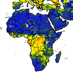
var dataset = ee.ImageCollection('NASA_USDA/HSL/SMAP10KM_soil_moisture')\n .filter(ee.Filter.date('2017-04-01', '2017-04-30'));\nvar soilMoisture = dataset.select('ssm');\nvar soilMoistureVis = {\n min: 0.0,\n max: 28.0,\n palette: ['0300ff', '418504', 'efff07', 'efff07', 'ff0303'],\n};\nMap.setCenter(-6.746, 46.529, 2);\nMap.addLayer(soilMoisture, soilMoistureVis, 'Soil Moisture');\n```\n[Open in Code Editor](https://code.earthengine.google.com/?scriptPath=Examples:Datasets/NASA_USDA/NASA_USDA_HSL_SMAP10KM_soil_moisture) \n[NASA-USDA Enhanced SMAP Global Soil Moisture Data \\[deprecated\\]](/earth-engine/datasets/catalog/NASA_USDA_HSL_SMAP10KM_soil_moisture) \nThe NASA-USDA Enhanced SMAP Global soil moisture data provides soil moisture information across the globe at 10-km spatial resolution. This dataset includes: surface, subsurface, soil moisture (mm), soil moisture profile (%), surface and subsurface soil moisture anomalies (-). The dataset is generated by integrating satellite-derived Soil Moisture Active Passive (SMAP) ... \nNASA_USDA/HSL/SMAP10KM_soil_moisture, geophysical,hsl,nasa,smap,soil,soil-moisture,usda \n2015-04-02T12:00:00Z/2022-08-02T12:00:00Z \n-60 -180 90 180 \nGoogle Earth Engine \nhttps://developers.google.com/earth-engine/datasets\n\n- [https://doi.org/10.5067/ZX7YX2Y2LHEB](https://doi.org/https://doi.org/10.1109/jstars.2021.3136756)\n- [https://doi.org/10.5067/ZX7YX2Y2LHEB](https://doi.org/https://developers.google.com/earth-engine/datasets/catalog/NASA_USDA_HSL_SMAP10KM_soil_moisture)"]]