Page Summary
-
Daymet V4 provides daily weather parameters for Continental North America, Hawaii, and Puerto Rico.
-
This dataset includes bands for daylight duration, precipitation, radiation, snow water equivalent, maximum and minimum temperature, and water vapor pressure.
-
Daymet V4 is an updated version with improvements to address known issues and biases from previous versions.
-
The dataset is available from 1980 to 2024 and is in the public domain without restrictions on use.
- Dataset Availability
- 1980-01-01T00:00:00Z–2024-12-30T00:00:00Z
- Dataset Producer
- NASA ORNL DAAC at Oak Ridge National Laboratory
- Cadence
- 1 Day
- Tags
Description
Daymet V4 provides gridded estimates of daily weather parameters for Continental North America, Hawaii, and Puerto Rico (Data for Puerto Rico is available starting in 1950). It is derived from selected meteorological station data and various supporting data sources.
Compared to the previous version, Daymet V4 provides effective solutions to known issues and further considers improvements to what were believed to be input weather station biases. Improvements include:
Reductions in the timing bias of input reporting weather station measurements.
Improvement to the three-dimensional regression model techniques in the core algorithm.
A novel approach to handling high elevation temperature measurement biases.
2020 and 2021 data are ingested from V4 R1 sources
Documentation:
Bands
Bands
Pixel size: 1000 meters (all bands)
| Name | Units | Min | Max | Pixel Size | Description |
|---|---|---|---|---|---|
dayl |
seconds | 0* | 86400* | 1000 meters | Duration of the daylight period. Based on the period of the day during which the sun is above a hypothetical flat horizon. |
prcp |
mm | 0* | 544* | 1000 meters | Daily total precipitation, sum of all forms converted to water-equivalent. |
srad |
W/m^2 | 0* | 1051* | 1000 meters | Incident shortwave radiation flux density, taken as an average over the daylight period of the day. |
swe |
kg/m^2 | 0* | 13931* | 1000 meters | Snow water equivalent, the amount of water contained within the snowpack. |
tmax |
°C | -60* | 60* | 1000 meters | Daily maximum 2-meter air temperature. |
tmin |
°C | -60* | 42* | 1000 meters | Daily minimum 2-meter air temperature. |
vp |
Pa | 0* | 8230* | 1000 meters | Daily average partial pressure of water vapor. |
Terms of Use
Terms of Use
This dataset is in the public domain and is available without restriction on use and distribution. See NASA's Earth Science Data & Information Policy for additional information.
Citations
Thornton, M.M., R. Shrestha, Y. Wei, P.E. Thornton, S-C. Kao, and B.E. Wilson. 2022. Daymet: Daily Surface Weather Data on a 1-km Grid for North America, Version 4 R1. ORNL DAAC, Oak Ridge, Tennessee, USA. https://doi.org/10.3334/ORNLDAAC/2129
Other Citation Details - Thornton, M.M., R. Shrestha, Y. Wei, P.E. Thornton, S. Kao, and B.E. Wilson. 2020. Daymet: Daily Surface Weather Data on a 1-km Grid for North America, Version 4. ORNL DAAC, Oak Ridge, Tennessee, USA. doi:10.3334/ORNLDAAC/1840
DOIs
Explore with Earth Engine
Code Editor (JavaScript)
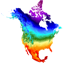
var dataset = ee.ImageCollection('NASA/ORNL/DAYMET_V4')
                  .filter(ee.Filter.date('2017-04-01', '2017-04-30'));
var maximumTemperature = dataset.select('tmax');
var maximumTemperatureVis = {
  min: -40.0,
  max: 30.0,
  palette: ['1621A2', 'white', 'cyan', 'green', 'yellow', 'orange', 'red'],
};
Map.setCenter(-110.21, 35.1, 4);
Map.addLayer(maximumTemperature, maximumTemperatureVis, 'Maximum Temperature');