Page Summary
-
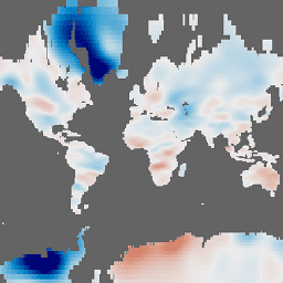
This dataset provides monthly gravitational anomalies as "Equivalent Water Thickness" in centimeters, relative to a 2004-2010 baseline.
-
The data is produced by three centers (CSR, GFZ, and JPL) and users are recommended to use the mean of the three datasets for most applications.
-
This dataset has been superseded by NASA/GRACE/MASS_GRIDS_V04/LAND.
-
The data is not well-suited for quantifying ice mass changes over Greenland, Antarctica, or glaciers and ice caps; the JPL mascon solution is recommended for those areas.
-
When using this data, an acknowledgment and specific citations are requested.
- Dataset Availability
- 2002-04-01T00:00:00Z–2017-01-07T00:00:00Z
- Dataset Producer
- NASA Jet Propulsion Laboratory
- Tags
Description
GRACE Tellus Monthly Mass Grids provides monthly gravitational anomalies relative to a 2004-2010 time-mean baseline. The data contained in this dataset are units of "Equivalent Water Thickness" which represent the deviations of mass in terms of vertical extent of water in centimeters. See the provider's Monthly Mass Grids Overview for more details.
The GRACE Tellus (GRCTellus) Monthly Mass Grids dataset is produced by three centers: CSR (U. Texas / Center for Space Research), GFZ (GeoForschungsZentrum Potsdam), and JPL (NASA Jet Propulsion Laboratory). Each center is a part of the GRACE Ground System and generates Level-2 data (spherical harmonic fields) used in this dataset. The output includes spherical harmonic coefficients of the gravity field and of the dealiasing fields used to compute them. Since each center independently produces the coefficients, the results may be slightly different. It is recommended for most users to use the mean of all three datasets. See the provider's choosing a solution page for more details.
Note
Due to the sampling and post-processing of GRACE observations, surface mass variations at small spatial scales tend to be attenuated. Therefore, users should multiply the GRCTellus Land data by the scaling grid available at NASA/GRACE/MASS_GRIDS/LAND_AUX_2014.
The GRCTellus Land grids processed from the Spherical Harmonic Level-2 data are not suited to accurately quantify ice mass changes over Greenland or Antarctica, or glaciers and ice caps. For those areas it is recommended to use JPL's mascon solution available as the following image collection: NASA/GRACE/MASS_GRIDS/MASCON
Bands
Bands
Pixel size: 111320 meters (all bands)
| Name | Units | Min | Max | Pixel Size | Description |
|---|---|---|---|---|---|
lwe_thickness_csr |
cm | -139.2* | 74.88* | 111320 meters | Equivalent liquid water thickness in centimeters calculated by CSR. |
lwe_thickness_gfz |
cm | -145.45* | 70.19* | 111320 meters | Equivalent liquid water thickness in centimeters calculated by GFZ. |
lwe_thickness_jpl |
cm | -137.94* | 71.86* | 111320 meters | Equivalent liquid water thickness in centimeters calculated by JPL. |
Image Properties
Image Properties
| Name | Type | Description |
|---|---|---|
| CSR_END_TIME | DOUBLE | End date in milliseconds of spherical harmonics solution from CSR. |
| CSR_START_TIME | DOUBLE | Start date in milliseconds of spherical harmonics solution from CSR. |
| GFZ_END_TIME | DOUBLE | End date in milliseconds of spherical harmonics solution from GFZ. |
| GFZ_START_TIME | DOUBLE | Start date in milliseconds of spherical harmonics solution from GFZ. |
| JPL_END_TIME | DOUBLE | End date in milliseconds of spherical harmonics solution from JPL. |
| JPL_START_TIME | DOUBLE | Start date in milliseconds of spherical harmonics solution from JPL. |
Terms of Use
Terms of Use
All NASA-produced data from the GRACE mission is made freely available for the public to use. When using any of the GRCTellus data, please add an acknowledgment: "GRACE land are available at https://grace.jpl.nasa.gov, supported by the NASA MEaSUREs Program." and cite with the citations provided.
Citations
S.C. Swenson. 2012. GRACE monthly land water mass grids NETCDF RELEASE 5.0. Ver. 5.0. PO.DAAC, CA, USA. Dataset accessed [YYYY-MM-DD] at https://doi.org/10.5067/TELND-NC005.
Landerer F.W. and S. C. Swenson, Accuracy of scaled GRACE terrestrial water storage estimates. Water Resources Research, Vol 48, W04531, 11 PP, doi:10.1029/2011WR011453, 2012.
Swenson, S. C. and J. Wahr, Post-processing removal of correlated errors in GRACE data, Geophys. Res. Lett., 33, L08402, doi:10.1029/2005GL025285, 2006.
DOIs
Explore with Earth Engine
Code Editor (JavaScript)
var dataset = ee.ImageCollection('NASA/GRACE/MASS_GRIDS/LAND')
                  .filter(ee.Filter.date('2016-08-01', '2016-08-30'));
var equivalentWaterThicknessCsr = dataset.select('lwe_thickness_csr');
var equivalentWaterThicknessCsrVis = {
  min: -25.0,
  max: 25.0,
};
Map.setCenter(6.746, 46.529, 2);
Map.addLayer(
    equivalentWaterThicknessCsr, equivalentWaterThicknessCsrVis,
    'Equivalent Water Thickness CSR');