- Доступность набора данных
- 1981-07-01T00:00:00Z–2013-12-16T00:00:00Z
- Производитель наборов данных
- НАСА/НОАА
- Каденция
- 15 дней
- Теги
- gimms
Описание
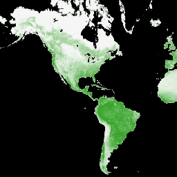
Индекс GIMMS NDVI генерируется на основе данных нескольких датчиков AVHRR NOAA для глобальной сетки координат с точностью до 1/12 градуса (широта/долгота). Последняя версия набора данных GIMMS NDVI называется NDVI3g (индекс GIMMS NDVI третьего поколения, полученный с помощью датчиков AVHRR).
Группы
Группы
Размер пикселя: 9277 метров (все диапазоны)
| Имя | Мин | Макс | Размер пикселя | Описание | |||||||||||||||||||||||||||||||||||||||||||||||||||||||||||||||||||||||||||||||||||||||||||||||
|---|---|---|---|---|---|---|---|---|---|---|---|---|---|---|---|---|---|---|---|---|---|---|---|---|---|---|---|---|---|---|---|---|---|---|---|---|---|---|---|---|---|---|---|---|---|---|---|---|---|---|---|---|---|---|---|---|---|---|---|---|---|---|---|---|---|---|---|---|---|---|---|---|---|---|---|---|---|---|---|---|---|---|---|---|---|---|---|---|---|---|---|---|---|---|---|---|---|---|---|
ndvi | -1 | 1 | 9277 метров | НДВИ | |||||||||||||||||||||||||||||||||||||||||||||||||||||||||||||||||||||||||||||||||||||||||||||||
qa | 9277 метров | флаг контроля качества | |||||||||||||||||||||||||||||||||||||||||||||||||||||||||||||||||||||||||||||||||||||||||||||||||
Условия эксплуатации
Условия эксплуатации
Данный набор данных находится в общественном достоянии и доступен без ограничений на использование и распространение. Дополнительную информацию см. в Политике НАСА в отношении данных и информации о науках о Земле .
Исследуйте мир с помощью Earth Engine.
Редактор кода (JavaScript)
var dataset = ee.ImageCollection('NASA/GIMMS/3GV0')
                  .filter(ee.Filter.date('2013-06-01', '2013-12-31'));
var ndvi = dataset.select('ndvi');
var ndviVis = {
  min: -1.0,
  max: 1.0,
  palette: ['000000', 'f5f5f5', '119701'],
};
Map.setCenter(-88.6, 26.4, 1);
Map.addLayer(ndvi, ndviVis, 'NDVI');