Page Summary
-
The NEX-GDDP-CMIP6 dataset provides global downscaled climate scenarios from 1950 to 2100, derived from CMIP6 GCM runs and two Shared Socioeconomic Pathways (SSPs).
-
This dataset, provided by NASA / Climate Analytics Group, includes daily climate projections and is comprised of data from 34 different models.
-
The dataset contains various bands providing information on climate variables such as temperature, precipitation, humidity, radiation, and wind speed.
-
Data may be interpolated for certain days when simulations do not produce daily bands, with specific models having different interpolation methods.
-
Use of the dataset is governed by the original CMIP6 Terms of Use, which may involve licenses such as CC-BY-4.0 or CC0-1.0.
- Dataset Availability
- 1950-01-01T00:00:00Z–2100-12-31T00:00:00Z
- Dataset Producer
- NASA / Climate Analytics Group
- Cadence
- 1 Day
- Tags
Description
The NEX-GDDP-CMIP6 dataset is comprised of global downscaled climate scenarios derived from the General Circulation Model (GCM) runs conducted under the Coupled Model Intercomparison Project Phase 6 (CMIP6, see Thrasher et al. 2022) and across two of the four "Tier 1" greenhouse gas emissions scenarios known as Shared Socioeconomic Pathways (SSPs).
The CMIP6 GCM runs were developed in support of the Sixth Assessment Report of the Intergovernmental Panel on Climate Change (IPCC AR6). This dataset includes downscaled projections from ScenarioMIP model runs for which daily scenarios were produced and distributed through the Earth System Grid Federation.
This collection contains 34 different models. One model, "GFDL-CM4," has data for two different configurations that can be differentiated by further filtering on the grid_label property.
Bands are replaced as new versions become available and the version property is updated with them.
See also the provider tech note.
You can submit data questions about CMIP6 to the provider and see their answers.
Bands
Bands
Pixel size: 27830 meters (all bands)
| Name | Units | Min | Max | Pixel Size | Description |
|---|---|---|---|---|---|
hurs |
% | -101.85* | 179.44* | 27830 meters | Near-surface relative humidity. Not present in these models: 'BCC-CSM2-MR', 'NESM3', 'KIOST-ESM' (only for scenario 'ssp245' in 2058). |
huss |
Mass fraction | -0.007* | 11.76* | 27830 meters | Near-surface specific humidity. Not present in these models: 'IPSL-CM6A-LR', 'MIROC6', 'NESM3'. |
pr |
kg/m^2/s | 0* | 0.0083* | 27830 meters | Precipitation (mean of the daily precipitation rate) |
rlds |
W/m^2 | -481.17* | 908.96* | 27830 meters | Surface downwelling longwave radiation |
rsds |
W/m^2 | -702710* | 553087* | 27830 meters | Surface downwelling shortwave radiation |
sfcWind |
m/s | -4.98* | 28.29* | 27830 meters | Daily-mean near-surface wind speed |
tas |
K | 192.15* | 336.94* | 27830 meters | Daily near-surface air temperature. Not present in these models: 'NorESM2-LM' (only for scenario 'ssp585' in 2096). |
tasmin |
K | 163.66* | 334.92* | 27830 meters | Daily minimum near-surface air temperature. Not present in these models: 'CESM2', 'CESM2-WACCM', 'IITM-ESM', 'TaiESM1' (only for scenario 'ssp585' in 2093). |
tasmax |
K | 202.09* | 352.77* | 27830 meters | Daily maximum near-surface air temperature. Not present in these models: 'CESM2', 'CESM2-WACCM', 'IITM-ESM'. |
Image Properties
Image Properties
| Name | Type | Description |
|---|---|---|
| model | STRING | Name of the CMIP6 model. It is one of:
|
| scenario | STRING | Name of the CMIP6 scenario. It is one of:
|
| year | DOUBLE | Calendar year |
| month | DOUBLE | Calendar month |
| day | DOUBLE | Calendar day |
| grid_label | STRING | The grid label, which is only set when differentiating simulation results for the 'GFDL-CM4' model. It is one of:
|
| license | STRING | The license under which a model is released. It will be one of:
|
| interpolated | STRING | Present and 'true' if data for a particular day has been filled in using the value from the previous day. This happens when the simulation does not produce a data band for every day in the year. The following models always duplicate the last day in leap years because they only yield 365 bands: 'BCC-CSM2-MR', 'CanESM5', 'CESM2', 'CESM2-WACCM', 'CMCC-CM2-SR5', 'CMCC-ESM2', 'FGOALS-g3', 'GFDL-CM4', 'GFDL-ESM4', 'GISS-E2-1-G', 'INM-CM4-8', 'INM-CM5-0', 'KIOST-ESM', 'NorESM2-LM', 'NorESM2-MM', 'TaiESM1'. These models yield 360 bands per year and have the outstanding 5 or 6 days filled by duplicating one every 60-70 days: 'HadGEM3-GC31-LL', 'HadGEM3-GC31-MM', 'KACE-1-0-G', 'UKESM1-0-LL'. 'IITM-ESM' only has 364 bands in years divisible by 5 (and does not have data for 2100 at all), so the final day is always duplicated, plus the midpoint day in leap years. |
| version | DOUBLE | The version of the asset, possible values are 1.0, 1.1 and 1.2 |
Terms of Use
Terms of Use
All CMIP6 GCM model inputs and any derivatives work, such as this dataset, are governed by the original Terms of use and may have some restrictions on usage. See the "license" property on each EE Image that notes the specific license the data may fall under.
(Note that while the official Terms of Use mention that some models are restricted under 'CC-BY-SA-4.0' (Creative Commons Attribution Share Alike 4.0 International), models available in Earth Engine either fall under 'CC-BY-4.0' (Creative Commons Attribution 4.0 International) or 'CC0-1.0' (Creative Commons Zero v1.0 Universal).)
Citations
Thrasher, B., Maurer, E. P., McKellar, C., & Duffy, P. B., 2012: Technical Note: Bias correcting climate model simulated daily temperature extremes with quantile mapping. Hydrology and Earth System Sciences, 16(9), 3309-3314. doi:10.5194/hess-16-3309-2012
Explore with Earth Engine
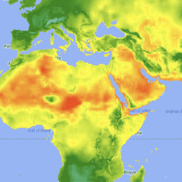
Code Editor (JavaScript)
var dataset = ee.ImageCollection('NASA/GDDP-CMIP6')
                  .filter(ee.Filter.date('2014-07-01', '2014-07-02'))
                  .filter(ee.Filter.eq('model', 'ACCESS-CM2'));
var minimumAirTemperature = dataset.select('tasmin');
var minimumAirTemperatureVis = {
  min: 240,
  max: 310,
  palette: ['blue', 'purple', 'cyan', 'green', 'yellow', 'red'],
};
Map.setCenter(71, 52, 3);
Map.addLayer(
    minimumAirTemperature, minimumAirTemperatureVis,
    'Minimum Air Temperature (K)');