The MYD15A2H V6.1 MODIS combined Leaf Area Index (LAI) and
Fraction of Photosynthetically Active Radiation (FPAR) product is an 8-day
composite dataset at 500m resolution. The algorithm chooses the "best" pixel
available from all the acquisitions of the Aqua sensor from within the 8-day period.
The MYD15A2H V6.1 MODIS combined Leaf Area Index (LAI) and Fraction of Photosynthetically Active Radiation (FPAR) product is an 8-day composite dataset at 500m resolution. The algorithm chooses the "best" pixel available from all the acquisitions of the Aqua sensor from within the 8-day period. Documentation: User's Guide Algorithm Theoretical …
[[["Easy to understand","easyToUnderstand","thumb-up"],["Solved my problem","solvedMyProblem","thumb-up"],["Other","otherUp","thumb-up"]],[["Missing the information I need","missingTheInformationINeed","thumb-down"],["Too complicated / too many steps","tooComplicatedTooManySteps","thumb-down"],["Out of date","outOfDate","thumb-down"],["Samples / code issue","samplesCodeIssue","thumb-down"],["Other","otherDown","thumb-down"]],[],[[["\u003cp\u003eMYD15A2H V6.1 is an 8-day composite dataset providing Leaf Area Index (LAI) and Fraction of Photosynthetically Active Radiation (FPAR) data at 500m resolution.\u003c/p\u003e\n"],["\u003cp\u003eThe dataset utilizes the Aqua sensor to select the best pixel within an 8-day period, covering the globe from 2002 to 2024.\u003c/p\u003e\n"],["\u003cp\u003eLAI and FPAR data are provided alongside quality control information and standard deviations for both measurements.\u003c/p\u003e\n"],["\u003cp\u003eMODIS data and products acquired through the LP DAAC have no restrictions on subsequent use, sale, or redistribution.\u003c/p\u003e\n"],["\u003cp\u003eUsers can access and analyze this dataset through Google Earth Engine, a platform for petabyte-scale scientific analysis and visualization of geospatial datasets.\u003c/p\u003e\n"]]],["The MYD15A2H V6.1 dataset provides 8-day composite measurements of Leaf Area Index (LAI) and Fraction of Photosynthetically Active Radiation (FPAR) at a 500m resolution, derived from the Aqua sensor. Data, which spans from July 4, 2002, to February 10, 2025, are accessible via Google Earth Engine. The dataset, provided by NASA LP DAAC at the USGS EROS Center, includes quality control metrics and standard deviations for LAI and FPAR. The algorithm selects the best pixel from the Aqua sensor's 8-day acquisitions.\n"],null,["Dataset Availability\n: 2002-07-04T00:00:00Z--2025-07-04T00:00:00Z\n\nDataset Provider\n:\n\n\n [NASA LP DAAC at the USGS EROS Center](https://doi.org/10.5067/MODIS/MYD15A2H.061)\n\nCadence\n: 8 Days\n\nTags\n:\n [8-day](/earth-engine/datasets/tags/8-day) [aqua](/earth-engine/datasets/tags/aqua) [fpar](/earth-engine/datasets/tags/fpar) [global](/earth-engine/datasets/tags/global) [lai](/earth-engine/datasets/tags/lai) [modis](/earth-engine/datasets/tags/modis) [nasa](/earth-engine/datasets/tags/nasa) [plant-productivity](/earth-engine/datasets/tags/plant-productivity) [usgs](/earth-engine/datasets/tags/usgs) \nmyd15a2h \n\nDescription \nThe MYD15A2H V6.1 MODIS combined Leaf Area Index (LAI) and\nFraction of Photosynthetically Active Radiation (FPAR) product is an 8-day\ncomposite dataset at 500m resolution. The algorithm chooses the \"best\" pixel\navailable from all the acquisitions of the Aqua sensor from within the 8-day period.\n\nDocumentation:\n\n- [User's Guide](https://lpdaac.usgs.gov/documents/624/MOD15_User_Guide_V6.pdf)\n\n- [Algorithm Theoretical Basis Document (ATBD)](https://lpdaac.usgs.gov/documents/90/MOD15_ATBD.pdf)\n\n- [General Documentation](https://ladsweb.modaps.eosdis.nasa.gov/filespec/MODIS/61/MYD15A2H)\n\nBands\n\n\n**Pixel Size**\n\n500 meters\n\n**Bands**\n\n| Name | Units | Min | Max | Scale | Description |\n|-------------------|---------------|-----|-----|-------|-------------------------------------------------|\n| `Fpar_500m` | % | 0 | 100 | 0.01 | Fraction of Photosynthetically Active Radiation |\n| `Lai_500m` | Area fraction | 0 | 100 | 0.1 | Leaf Area Index |\n| `FparLai_QC` | None | 0 | 254 | | Quality for LAI and FPAR |\n| `FparExtra_QC` | None | 0 | 254 | | Extra detail Quality for LAI and FPAR |\n| `FparStdDev_500m` | % | 0 | 100 | 0.01 | Standard deviation of FPAR |\n| `LaiStdDev_500m` | Area fraction | 0 | 100 | 0.1 | Standard deviation of LAI |\n\nTerms of Use\n\n**Terms of Use**\n\nMODIS data and products acquired through the LP DAAC\nhave no restrictions on subsequent use, sale, or redistribution.\n\nCitations \nCitations:\n\n- Please visit [LP DAAC 'Citing Our Data' page](https://lpdaac.usgs.gov/citing_our_data)\n for information on citing LP DAAC datasets.\n\nDOIs\n\n- \u003chttps://doi.org/10.5067/MODIS/MYD15A2H.061\u003e\n\n
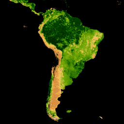
Explore with Earth Engine **Important:** Earth Engine is a platform for petabyte-scale scientific analysis and visualization of geospatial datasets, both for public benefit and for business and government users. Earth Engine is free to use for research, education, and nonprofit use. To get started, please [register for Earth Engine access.](https://console.cloud.google.com/earth-engine)\n\nCode Editor (JavaScript) \n\n```javascript\nvar collection = ee.ImageCollection('MODIS/061/MYD15A2H')\n .filterDate('2019-01-01', '2019-10-01');\n\nvar colorizedVis = {\n min: 0,\n max: 100,\n palette: [\n 'ffffff', 'ce7e45', 'df923d', 'f1b555', 'fcd163', '99b718', '74a901',\n '66a000', '529400', '3e8601', '207401', '056201', '004c00', '023b01',\n '012e01', '011d01', '011301'\n ],\n};\n\nMap.setCenter(-10.88, 40.94, 2);\nMap.addLayer(collection.select('Lai_500m'), colorizedVis, 'Lai');\nMap.addLayer(collection.select('Fpar_500m'), colorizedVis, 'Fpar');\n```\n[Open in Code Editor](https://code.earthengine.google.com/?scriptPath=Examples:Datasets/MODIS/MODIS_061_MYD15A2H) \n[MYD15A2H.061: Aqua Leaf Area Index/FPAR 8-Day Global 500m](/earth-engine/datasets/catalog/MODIS_061_MYD15A2H) \nThe MYD15A2H V6.1 MODIS combined Leaf Area Index (LAI) and Fraction of Photosynthetically Active Radiation (FPAR) product is an 8-day composite dataset at 500m resolution. The algorithm chooses the \"best\" pixel available from all the acquisitions of the Aqua sensor from within the 8-day period. Documentation: User's Guide Algorithm Theoretical ... \nMODIS/061/MYD15A2H, 8-day,aqua,fpar,global,lai,modis,nasa,plant-productivity,usgs \n2002-07-04T00:00:00Z/2025-07-04T00:00:00Z \n-90 -180 90 180 \nGoogle Earth Engine \nhttps://developers.google.com/earth-engine/datasets\n\n- [https://doi.org/10.5067/MODIS/MYD15A2H.061](https://doi.org/https://doi.org/10.5067/MODIS/MYD15A2H.061)\n- [https://doi.org/10.5067/MODIS/MYD15A2H.061](https://doi.org/https://developers.google.com/earth-engine/datasets/catalog/MODIS_061_MYD15A2H)"]]