Page Summary
-
The Aqua MODIS Vegetation Indices 16-Day (MYD13C1) product provides Normalized Difference Vegetation Index (NDVI) and Enhanced Vegetation Index (EVI) values globally every 16 days at a 0.05 degree resolution.
-
The dataset is available from July 4, 2002, to September 22, 2025, and is provided by NASA LP DAAC at the USGS EROS Center.
-
Bands in the dataset include NDVI, EVI, quality indicators, surface reflectance bands, and solar zenith angle.
-
MODIS data and products acquired through the LP DAAC have no restrictions on subsequent use, sale, or redistribution.
-
The dataset can be explored and analyzed using Google Earth Engine.
- Dataset Availability
- 2002-07-04T00:00:00Z–2026-07-04T00:00:00Z
- Dataset Producer
- NASA LP DAAC at the USGS EROS Center
- Cadence
- 16 Days
- Tags
Description
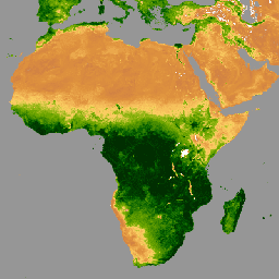
The Aqua Moderate Resolution Imaging Spectroradiometer (MODIS) Vegetation Indices 16-Day (MYD13C1) Version 6.1 product provides a Vegetation Index (VI) value at a per pixel basis. There are two primary vegetation layers. The first is the Normalized Difference Vegetation Index (NDVI), which maintains continuity with the existing National Oceanic and Atmospheric Administration-Advanced Very High Resolution Radiometer (NOAA-AVHRR) derived NDVI. The second vegetation layer is the Enhanced Vegetation Index (EVI), which has improved sensitivity over high biomass regions.
The Climate Modeling Grid (CMG) consists of 3,600 rows and 7,200 columns of 5,600 meter (m) pixels. Global MYD13C1 data are cloud-free spatial composites of the gridded 16-day 1 kilometer MYD13A2 data, and are provided as a Level 3 product projected on a 0.05 degree (5,600 m) geographic CMG. The MYD13C1 has data fields for NDVI, EVI, VI QA, reflectance data, angular information, and spatial statistics such as mean, standard deviation, and number of used input pixels at the 0.05 degree CMG resolution.
Note that scale factors and offsets described in the MODIS documentation for MYD13C1 bands are already applied to assets ingested into Earth Engine.
Bands
Bands
Pixel size: 5600 meters (all bands)
| Name | Units | Min | Max | Pixel Size | Wavelength | Description | |||||||||||||||||||||||||||||||||||||||||||||||||||||||||||||||||||||||||||||||||||||||||||||
|---|---|---|---|---|---|---|---|---|---|---|---|---|---|---|---|---|---|---|---|---|---|---|---|---|---|---|---|---|---|---|---|---|---|---|---|---|---|---|---|---|---|---|---|---|---|---|---|---|---|---|---|---|---|---|---|---|---|---|---|---|---|---|---|---|---|---|---|---|---|---|---|---|---|---|---|---|---|---|---|---|---|---|---|---|---|---|---|---|---|---|---|---|---|---|---|---|---|---|---|
NDVI |
-0.2 | 1 | 5600 meters | None | 16-day NDVI average |
||||||||||||||||||||||||||||||||||||||||||||||||||||||||||||||||||||||||||||||||||||||||||||||
EVI |
-0.2 | 1 | 5600 meters | None | 16-day EVI average |
||||||||||||||||||||||||||||||||||||||||||||||||||||||||||||||||||||||||||||||||||||||||||||||
DetailedQA |
5600 meters | None | VI Quality indicators |
||||||||||||||||||||||||||||||||||||||||||||||||||||||||||||||||||||||||||||||||||||||||||||||||
sur_refl_b01 |
0 | 1 | 5600 meters | 620-670nm | Surface reflectance band 1 (red) |
||||||||||||||||||||||||||||||||||||||||||||||||||||||||||||||||||||||||||||||||||||||||||||||
sur_refl_b02 |
0 | 1 | 5600 meters | 841-876nm | Surface reflectance band 2 (near-infrared) |
||||||||||||||||||||||||||||||||||||||||||||||||||||||||||||||||||||||||||||||||||||||||||||||
sur_refl_b03 |
0 | 1 | 5600 meters | 459-479nm | Surface reflectance band 3 (blue) |
||||||||||||||||||||||||||||||||||||||||||||||||||||||||||||||||||||||||||||||||||||||||||||||
sur_refl_b07 |
0 | 1 | 5600 meters | 2105-2155nm | Surface reflectance band 7 (mid-infrared) |
||||||||||||||||||||||||||||||||||||||||||||||||||||||||||||||||||||||||||||||||||||||||||||||
SolarZenith |
deg | 0 | 180 | 5600 meters | None | View zenith angle of VI Pixel |
|||||||||||||||||||||||||||||||||||||||||||||||||||||||||||||||||||||||||||||||||||||||||||||
NDVIStdDev |
-0.2 | 1 | 5600 meters | None | Standard deviation computed from input NDVI pixels |
||||||||||||||||||||||||||||||||||||||||||||||||||||||||||||||||||||||||||||||||||||||||||||||
EVIStdDev |
-0.2 | 1 | 5600 meters | None | Standard deviation computed from input NDVI pixels |
||||||||||||||||||||||||||||||||||||||||||||||||||||||||||||||||||||||||||||||||||||||||||||||
Pixel_1km |
count | 0 | 36 | 5600 meters | None | Number of 1 km input pixels used |
|||||||||||||||||||||||||||||||||||||||||||||||||||||||||||||||||||||||||||||||||||||||||||||
Pixel_30deg_1km |
count | 0 | 36 | 5600 meters | None | Number of 1 km input pixels used with VZ angle less than + or - 30 degs |
|||||||||||||||||||||||||||||||||||||||||||||||||||||||||||||||||||||||||||||||||||||||||||||
SummaryQA |
5600 meters | None | Quality reliability of VI pixel |
||||||||||||||||||||||||||||||||||||||||||||||||||||||||||||||||||||||||||||||||||||||||||||||||
SummaryQA Class Table
| Value | Color | Description |
|---|---|---|
| 0 | None | Good Data: use with confidence |
| 1 | None | Marginal Data: useful, but look at other QA information |
| 2 | None | Snow/Ice: target covered with snow/ice |
| 3 | None | Cloudy: target not visible, covered with cloud |
Terms of Use
Terms of Use
MODIS data and products acquired through the LP DAAC have no restrictions on subsequent use, sale, or redistribution.
Citations
Please visit LP DAAC 'Citing Our Data' page for information on citing LP DAAC datasets.
DOIs
Explore with Earth Engine
Code Editor (JavaScript)
var dataset = ee.ImageCollection('MODIS/061/MYD13C1')
                  .filter(ee.Filter.date('2023-01-01', '2023-05-01'));
var ndvi = dataset.select('NDVI');
var ndviVis = {
  min: 0,
  max: .9,
  palette: [
    'ffffff', 'ce7e45', 'df923d', 'f1b555', 'fcd163', '99b718', '74a901',
    '66a000', '529400', '3e8601', '207401', '056201', '004c00', '023b01',
    '012e01', '011d01', '011301'
  ],
};
Map.setCenter(6.746, 46.529, 2);
Map.addLayer(ndvi, ndviVis, 'NDVI');