Page Summary
-
This dataset has been superseded by MODIS/061/MCD43C3.
-
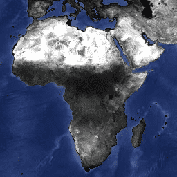
The dataset provides daily Bidirectional Reflectance Distribution Function and Albedo (BRDF/Albedo) data using Terra and Aqua MODIS data in a 0.05 degree Climate Modeling Grid.
-
It includes layers for black-sky and white-sky albedo at local solar noon across various MODIS spectral bands and broader visible, NIR, and shortwave bands, along with ancillary data.
-
Data is available from February 24, 2000 to February 10, 2023 and has no restrictions on subsequent use, sale, or redistribution.
-
The dataset's pixel size is 5600 meters.

- Dataset Availability
- 2000-02-24T00:00:00Z–2023-02-10T00:00:00Z
- Dataset Producer
- NASA LP DAAC at the USGS EROS Center Google Earth Engine
- Cadence
- 1 Day
- Tags
Description
The MCD43C3 Version 6 Bidirectional Reflectance Distribution Function and Albedo (BRDF/Albedo) Albedo dataset is produced daily using 16 days of Terra and Aqua MODIS data in a 0.05 degree (5,600 meters at the equator) Climate Modeling Grid (CMG). Data are temporally weighted to the ninth day of the retrieval period which is reflected in the Julian date in the file name. This CMG product covers the entire globe for use in climate simulation models.
MCD43C3 provides black-sky albedo (directional hemispherical reflectance) and white-sky albedo (bihemispherical reflectance) at local solar noon. Black-sky albedo and white-sky albedo values are available as a separate layer for MODIS spectral bands 1 through 7 as well as the visible, near infrared (NIR), and shortwave bands. Along with the 20 albedo layers are ancillary layers for quality, local solar noon, percent finer resolution inputs, snow cover, and uncertainty.
See dataset user guide for more information.
Bands
Pixel Size
5600 meters
Bands
| Name | Units | Min | Max | Scale | Pixel Size | Wavelength | Description | ||||||||||||||||||||||||||||||||||||||||||||||||||||||||||||||||||||||||||||||||||||||||||||
|---|---|---|---|---|---|---|---|---|---|---|---|---|---|---|---|---|---|---|---|---|---|---|---|---|---|---|---|---|---|---|---|---|---|---|---|---|---|---|---|---|---|---|---|---|---|---|---|---|---|---|---|---|---|---|---|---|---|---|---|---|---|---|---|---|---|---|---|---|---|---|---|---|---|---|---|---|---|---|---|---|---|---|---|---|---|---|---|---|---|---|---|---|---|---|---|---|---|---|---|
Albedo_BSA_Band1 |
0 | 32766 | 0.001 | meters | 620-670nm | Black-sky albedo for band 1 |
|||||||||||||||||||||||||||||||||||||||||||||||||||||||||||||||||||||||||||||||||||||||||||||
Albedo_BSA_Band2 |
0 | 32766 | 0.001 | meters | 841-876nm | Black-sky albedo for band 2 |
|||||||||||||||||||||||||||||||||||||||||||||||||||||||||||||||||||||||||||||||||||||||||||||
Albedo_BSA_Band3 |
0 | 32766 | 0.001 | meters | 459-479nm | Black-sky albedo for band 3 |
|||||||||||||||||||||||||||||||||||||||||||||||||||||||||||||||||||||||||||||||||||||||||||||
Albedo_BSA_Band4 |
0 | 32766 | 0.001 | meters | 545-565nm | Black-sky albedo for band 4 |
|||||||||||||||||||||||||||||||||||||||||||||||||||||||||||||||||||||||||||||||||||||||||||||
Albedo_BSA_Band5 |
0 | 32766 | 0.001 | meters | 1230-1250nm | Black-sky albedo for band 5 |
|||||||||||||||||||||||||||||||||||||||||||||||||||||||||||||||||||||||||||||||||||||||||||||
Albedo_BSA_Band6 |
0 | 32766 | 0.001 | meters | 1628-1652nm | Black-sky albedo for band 6 |
|||||||||||||||||||||||||||||||||||||||||||||||||||||||||||||||||||||||||||||||||||||||||||||
Albedo_BSA_Band7 |
0 | 32766 | 0.001 | meters | 2105-2155nm | Black-sky albedo for band 7 |
|||||||||||||||||||||||||||||||||||||||||||||||||||||||||||||||||||||||||||||||||||||||||||||
Albedo_BSA_vis |
0 | 32766 | 0.001 | meters | None | Black-sky albedo for visible brodband |
|||||||||||||||||||||||||||||||||||||||||||||||||||||||||||||||||||||||||||||||||||||||||||||
Albedo_BSA_nir |
0 | 32766 | 0.001 | meters | 858nm | Black-sky albedo for NIR broadband |
|||||||||||||||||||||||||||||||||||||||||||||||||||||||||||||||||||||||||||||||||||||||||||||
Albedo_BSA_shortwave |
0 | 32766 | 0.001 | meters | None | Black-sky albedo for shortwave broadband |
|||||||||||||||||||||||||||||||||||||||||||||||||||||||||||||||||||||||||||||||||||||||||||||
Albedo_WSA_Band1 |
0 | 32766 | 0.001 | meters | 620-670nm | White-sky albedo for band 1 |
|||||||||||||||||||||||||||||||||||||||||||||||||||||||||||||||||||||||||||||||||||||||||||||
Albedo_WSA_Band2 |
0 | 32766 | 0.001 | meters | 841-876nm | White-sky albedo for band 2 |
|||||||||||||||||||||||||||||||||||||||||||||||||||||||||||||||||||||||||||||||||||||||||||||
Albedo_WSA_Band3 |
0 | 32766 | 0.001 | meters | 459-479nm | White-sky albedo for band 3 |
|||||||||||||||||||||||||||||||||||||||||||||||||||||||||||||||||||||||||||||||||||||||||||||
Albedo_WSA_Band4 |
0 | 32766 | 0.001 | meters | 545-565nm | White-sky albedo for band 4 |
|||||||||||||||||||||||||||||||||||||||||||||||||||||||||||||||||||||||||||||||||||||||||||||
Albedo_WSA_Band5 |
0 | 32766 | 0.001 | meters | 1230-1250nm | White-sky albedo for band 5 |
|||||||||||||||||||||||||||||||||||||||||||||||||||||||||||||||||||||||||||||||||||||||||||||
Albedo_WSA_Band6 |
0 | 32766 | 0.001 | meters | 1628-1652nm | White-sky albedo for band 6 |
|||||||||||||||||||||||||||||||||||||||||||||||||||||||||||||||||||||||||||||||||||||||||||||
Albedo_WSA_Band7 |
0 | 32766 | 0.001 | meters | 2105-2155nm | White-sky albedo for band 7 |
|||||||||||||||||||||||||||||||||||||||||||||||||||||||||||||||||||||||||||||||||||||||||||||
Albedo_WSA_vis |
0 | 32766 | 0.001 | meters | None | White-sky albedo for visible broadband |
|||||||||||||||||||||||||||||||||||||||||||||||||||||||||||||||||||||||||||||||||||||||||||||
Albedo_WSA_nir |
0 | 32766 | 0.001 | meters | 858nm | White-sky albedo for NIR broadband |
|||||||||||||||||||||||||||||||||||||||||||||||||||||||||||||||||||||||||||||||||||||||||||||
Albedo_WSA_shortwave |
0 | 32766 | 0.001 | meters | None | White-sky albedo for shortwave broadband |
|||||||||||||||||||||||||||||||||||||||||||||||||||||||||||||||||||||||||||||||||||||||||||||
BRDF_Quality |
meters | None | Global albedo quality |
||||||||||||||||||||||||||||||||||||||||||||||||||||||||||||||||||||||||||||||||||||||||||||||||
Local_Solar_Noon |
deg | 0 | 90 | meters | None | Local solar noon zenith angle |
|||||||||||||||||||||||||||||||||||||||||||||||||||||||||||||||||||||||||||||||||||||||||||||
Percent_Inputs |
% | 0 | 100 | meters | None | Percent of the processed finer resolution data which contributed to this CMG pixel |
|||||||||||||||||||||||||||||||||||||||||||||||||||||||||||||||||||||||||||||||||||||||||||||
Percent_Snow |
% | 0 | 100 | meters | None | Percent of underlying data flagged as snow |
|||||||||||||||||||||||||||||||||||||||||||||||||||||||||||||||||||||||||||||||||||||||||||||
BRDF_Albedo_Uncertainty |
0 | 32766 | 0.001 | meters | None | BRDF inversion information. Weights of determination (WoD) of the white sky albedo (see Lucht, W., & Lewis, P. (2000). Theoretical noise sensitivity of BRDF and albedo retrieval from the EOS-MODIS and MISR sensors with respect to angular sampling. International Journal of Remote Sensing, 21(1), 81-98). WoDs give a measure of the uncertainty due to the angular sampling of the inputs available for each retrieval. |
|||||||||||||||||||||||||||||||||||||||||||||||||||||||||||||||||||||||||||||||||||||||||||||
Terms of Use
Terms of Use
MODIS data and products acquired through the LP DAAC have no restrictions on subsequent use, sale, or redistribution.
Citations
Please visit LP DAAC 'Citing Our Data' page for information on citing LP DAAC datasets.
DOIs
Explore with Earth Engine
Code Editor (JavaScript)
var dataset = ee.ImageCollection('MODIS/006/MCD43C3')
                  .filter(ee.Filter.date('2018-01-01', '2018-05-01'));
var blackSkyAlbedo = dataset.select('Albedo_BSA_Band1');
var blackSkyAlbedoVis = {
  min: 0,
  max: 400,
};
Map.setCenter(6.746, 46.529, 6);
Map.addLayer(blackSkyAlbedo, blackSkyAlbedoVis, 'Black-Sky Albedo');