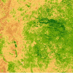
이러한 Landsat 4 TM Collection 1 Tier 1 컴포지트는 계산된 대기권 상단 (TOA) 반사율을 사용하여 Tier 1 직교 보정 장면으로 만들어집니다. TOA 계산에 관한 자세한 내용은 Chander et al. (2009)을 참고하세요. 정규화된 식생 지수는 각 장면의 근적외선 및 적색 밴드에서 다음과 같이 생성됩니다.
[[["이해하기 쉬움","easyToUnderstand","thumb-up"],["문제가 해결됨","solvedMyProblem","thumb-up"],["기타","otherUp","thumb-up"]],[["필요한 정보가 없음","missingTheInformationINeed","thumb-down"],["너무 복잡함/단계 수가 너무 많음","tooComplicatedTooManySteps","thumb-down"],["오래됨","outOfDate","thumb-down"],["번역 문제","translationIssue","thumb-down"],["샘플/코드 문제","samplesCodeIssue","thumb-down"],["기타","otherDown","thumb-down"]],[],[],["This dataset provides Landsat 4 TM Collection 1 Tier 1 annual composites from 1982 to 1993, derived from orthorectified scenes with top-of-atmosphere (TOA) reflectance. The Normalized Difference Vegetation Index (NDVI), calculated from Near-IR and Red bands, ranges from -1 to 1, with a 30-meter pixel size. Composites are built using all annual scenes, keeping the most recent pixel's value. The data, is in the public domain and is provided by the USGS, and is accessible via Google Earth Engine. This dataset has been replaced by another one.\n"]]