Page Summary
-
This dataset provides a global rural-urban classification based on the "Degree of Urbanisation" methodology, available multitemporally from 1975 to 2030 in 5-year intervals.
-
The classification is derived from global gridded population and built-up surface data generated by the GHSL project, specifically integrating information from GHS-BUILT-S R2023 and GHS-POP R2023.
-
This dataset is considered deprecated and has been superseded by the JRC/GHSL/P2023A/GHS_SMOD_V2-0 dataset.
-
The data is provided at a pixel size of 1000 meters and includes a classification table for the 'smod_code' band.
-
This GHSL dataset is open and free to use, with reuse authorized provided the source is acknowledged.
- Dataset Availability
- 1975-01-01T00:00:00Z–2030-12-31T00:00:00Z
- Dataset Producer
- EC JRC
- Tags
Description
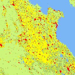
This raster dataset represents a global, multitemporal rural-urban classification, applying the "Degree of Urbanisation" stage I methodology recommended by UN Statistical Commission, based on global gridded population and built-up surface data generated by the GHSL project for the epochs 1975-2030 in 5-year intervals. The Degree of Urbanisation layers have been generated by integrating information on built-up surface extracted from Landsat and Sentinel-2 data GHS-BUILT-S R2023, and gridded population data derived from CIESIN GPW v4.11 GHS-POP R2023. This product is an update of the data released in 2022 based on the updates of the GHS-BUILT-S and GHS-POP. The Settlement Model is provided at the detailed level (Second Level - L2). The first-level classification can be obtained by aggregating L2.
The complete information about the GHSL main products can be found in the GHSL Data Package 2023 report
The Global Human Settlement Layer (GHSL) project is supported by the European Commission, Joint Research Center, and Directorate-General for Regional and Urban Policy.
Bands
Bands
Pixel size: 1000 meters (all bands)
| Name | Pixel Size | Description |
|---|---|---|
smod_code |
1000 meters | Degree of urbanization |
smod_code Class Table
| Value | Color | Description |
|---|---|---|
| -200 | #000000 | No Data |
| 10 | #7ab6f5 | Water |
| 11 | #cdf57a | Very low density rural |
| 12 | #abcd66 | Low density rural |
| 13 | #375623 | Rural cluster |
| 21 | #ffff00 | Suburban or peri-urban |
| 22 | #a87000 | Semi-dense urban cluster |
| 23 | #732600 | Dense urban cluster |
| 30 | #ff0000 | Urban centre |
Terms of Use
Terms of Use
The GHSL has been produced by the European Commission Joint Research Centre as open and free data. Reuse is authorised, provided the source is acknowledged. For more information, please read the use conditions (European Commission Reuse and Copyright Notice).
Citations
Schiavina, Marcello; Melchiorri, Michele; Pesaresi, Martino (2023): GHS-SMOD R2023A - GHS settlement layers, application of the Degree of Urbanisation methodology (stage I) to GHS-POP R2023A and GHS-BUILT-S R2023A, multitemporal (1975-2030). European Commission, Joint Research Centre (JRC) PID: http://data.europa.eu/89h/a0df7a6f-49de-46ea-9bde-563437a6e2ba doi:10.2905/A0DF7A6F-49DE-46EA-9BDE-563437A6E2BA
DOIs
Explore with Earth Engine
Code Editor (JavaScript)
var image = ee.Image("JRC/GHSL/P2023A/GHS_SMOD/2030");
var smod = image.select('smod_code');
Map.setCenter(84, 25, 5);
Map.addLayer(image, {}, 'Degree of Urbanization');