Page Summary
-
This dataset, superseded by a newer version, contains outlines of 816 million buildings in Africa, South Asia, and Southeast Asia derived from high-resolution satellite imagery.
-
Each building entry includes its ground footprint polygon, a confidence score, and a Plus Code for its center, but no other details like building type or address.
-
Building footprints in this dataset are useful for applications such as population estimation, urban planning, humanitarian response, and environmental science.
-
The data was inferred in August 2022 and is available under the CC-BY-4.0 license.
- Dataset Availability
- 2022-08-30T00:00:00Z–2022-08-30T00:00:00Z
- Dataset Producer
- Google Research - Open Buildings
- Tags
Description
This large-scale open dataset consists of outlines of buildings derived from high-resolution 50 cm satellite imagery. It contains 816M building detections in Africa, South Asia and Southeast Asia. The inference spanned an area of 39.1M km².
For each building in this dataset we include the polygon describing its footprint on the ground, a confidence score indicating how sure we are that this is a building, and a Plus Code corresponding to the center of the building. There is no information about the type of building, its street address, or any details other than its geometry.
Building footprints are useful for a range of important applications: from population estimation, urban planning and humanitarian response to environmental and climate science. The project being based in Ghana, the current focus is on the continent of Africa.
Inference was carried out during Aug 2022.
For more details see the official website of the Open Buildings dataset.
Note that updated versions of this data are available. The newest version, Version 3.0 (with inference carried out on May 2023), is available as GOOGLE/Research/open-buildings/v3/polygons.
Table Schema
Table Schema
| Name | Type | Description |
|---|---|---|
| area_in_meters | DOUBLE | Area in square meters of the polygon. |
| confidence | DOUBLE | Confidence score [0.5;1.0] assigned by the model. |
| full_plus_code | STRING | The full Plus Code at the building polygon centroid. |
| longitude_latitude | GEOMETRY | Centroid of the polygon. |
Terms of Use
Terms of Use
Citations
W. Sirko, S. Kashubin, M. Ritter, A. Annkah, Y.S.E. Bouchareb, Y. Dauphin, D. Keysers, M. Neumann, M. Cisse, J.A. Quinn. Continental-scale building detection from high resolution satellite imagery. arXiv:2107.12283, 2021.
Explore with Earth Engine
Code Editor (JavaScript)
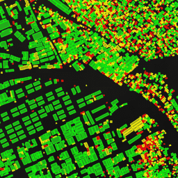
// Visualization of GOOGLE/Research/open-buildings/v2/polygons.

var t = ee.FeatureCollection('GOOGLE/Research/open-buildings/v2/polygons');

var t_060_065 = t.filter('confidence >= 0.60 && confidence < 0.65');
var t_065_070 = t.filter('confidence >= 0.65 && confidence < 0.70');
var t_gte_070 = t.filter('confidence >= 0.70');

Map.addLayer(t_060_065, {color: 'FF0000'}, 'Buildings confidence [0.60; 0.65)');
Map.addLayer(t_065_070, {color: 'FFFF00'}, 'Buildings confidence [0.65; 0.70)');
Map.addLayer(t_gte_070, {color: '00FF00'}, 'Buildings confidence >= 0.70');
Map.setCenter(3.389, 6.492, 17);  // Lagos, Nigeria
Map.setOptions('SATELLITE');
import ee
import geemap.core as geemap
Colab (Python)
# Visualization of GOOGLE/Research/open-buildings/v2/polygons.
t = ee.FeatureCollection('GOOGLE/Research/open-buildings/v2/polygons')

t_060_065 = t.filter('confidence >= 0.60 && confidence < 0.65')
t_065_070 = t.filter('confidence >= 0.65 && confidence < 0.70')
t_gte_070 = t.filter('confidence >= 0.70');

m = geemap.Map()
m.set_center(3.389, 6.492, 17)
m.add_layer(t_060_065, {'color': 'FF0000'}, 'Buildings confidence [0.60; 0.65)')
m.add_layer(t_065_070, {'color': 'FFFF00'}, 'Buildings confidence [0.65; 0.70)')
m.add_layer(t_gte_070, {'color': '00FF00'}, 'Buildings confidence >= 0.70')
m
Visualize as a FeatureView
A FeatureView is a view-only, accelerated representation of a
FeatureCollection. For more details, visit the
FeatureView documentation.
Code Editor (JavaScript)
var fvLayer = ui.Map.FeatureViewLayer(
  'GOOGLE/Research/open-buildings/v2/polygons_FeatureView');

var visParams = {
  rules: [
    {
      filter: ee.Filter.expression('confidence >= 0.60 && confidence < 0.65'),
      color: 'FF0000'
    },
    {
      filter: ee.Filter.expression('confidence >= 0.65 && confidence < 0.70'),
      color: 'FFFF00'
    },
    {
      filter: ee.Filter.expression('confidence >= 0.70'),
      color: '00FF00'
    },
  ]
};

fvLayer.setVisParams(visParams);
fvLayer.setName('Buildings');

Map.setCenter(3.389, 6.492, 17);  // Lagos, Nigeria
Map.add(fvLayer);
Map.setOptions('SATELLITE');
import ee
import geemap.core as geemap
Colab (Python)
# Visualization of GOOGLE/Research/open-buildings/v2/polygons.
t = ee.FeatureCollection('GOOGLE/Research/open-buildings/v2/polygons')

t_060_065 = t.filter('confidence >= 0.60 && confidence < 0.65')
t_065_070 = t.filter('confidence >= 0.65 && confidence < 0.70')
t_gte_070 = t.filter('confidence >= 0.70');

m = geemap.Map()
m.set_center(3.389, 6.492, 17)
m.add_layer(t_060_065, {'color': 'FF0000'}, 'Buildings confidence [0.60; 0.65)')
m.add_layer(t_065_070, {'color': 'FFFF00'}, 'Buildings confidence [0.65; 0.70)')
m.add_layer(t_gte_070, {'color': '00FF00'}, 'Buildings confidence >= 0.70')
m