- Verfügbarkeit des Datasets
- 2021-01-01T00:00:00Z–2022-01-01T00:00:00Z
- Ersteller des Datasets
- ESA WorldCover Consortium
- Tags
Beschreibung
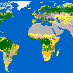
Das Produkt „WorldCover 10 m 2021“ der Europäischen Weltraumorganisation (ESA) enthält eine globale Karte der Bodenbedeckung für 2021 mit einer Auflösung von 10 m auf Basis von Sentinel-1- und Sentinel-2-Daten. Das Produkt „WorldCover“ ist in 11 Landbedeckungsklassen unterteilt und wurde im Rahmen des ESA WorldCover-Projekts erstellt, das Teil des 5. Erdbeobachtungsprogramms (EOEP-5) der Europäischen Weltraumorganisation (ESA) ist.
Siehe auch:
Bänder
Bänder
Pixelgröße: 10 Meter (alle Bänder)
| Name | Pixelgröße | Beschreibung |
|---|---|---|
Map |
10 Meter | Klasse der Bodenbedeckung |
Tabelle der Kartenklassen
| Wert | Farbe | Beschreibung |
|---|---|---|
| 10 | #006400 | Baumbestand |
| 20 | #ffbb22 | Shrubland |
| 30 | #ffff4c | Wiese |
| 40 | #f096ff | Ackerland |
| 50 | #fa0000 | Siedlungsgebiet |
| 60 | #b4b4b4 | Karge / spärliche Vegetation |
| 70 | #f0f0f0 | Schnee und Eis |
| 80 | #0064c8 | Permanente Gewässer |
| 90 | #0096a0 | Krautige Feuchtgebiete |
| 95 | #00cf75 | Mangroven |
| 100 | #fae6a0 | Moos und Flechten |
Nutzungsbedingungen
Nutzungsbedingungen
Zitate
Zanaga, D., Van De Kerchove, R., Daems, D., De Keersmaecker, W., Brockmann, C., Kirches, G., Wevers, J., Cartus, O., Santoro, M., Fritz, S., Lesiv, M., Herold, M., Tsendbazar, N.E., Xu, P., Ramoino, F., Arino, O., 2022. ESA WorldCover 10 m 2021 v200. (doi:10.5281/zenodo.7254221)
Die Earth Engine nutzen
Code-Editor (JavaScript)
var dataset = ee.ImageCollection('ESA/WorldCover/v200').first();

var visualization = {
  bands: ['Map'],
};

Map.centerObject(dataset);

Map.addLayer(dataset, visualization, 'Landcover');
import ee
import geemap.core as geemap
Colab (Python)
dataset = ee.ImageCollection('ESA/WorldCover/v200').first()

visualization = {'bands': ['Map']}

m = geemap.Map()
m.center_object(dataset)
m.add_layer(dataset, visualization, 'Landcover')
m