- Доступность набора данных
- 2006-01-24T00:00:00Z–2011-05-13T00:00:00Z
- Производитель наборов данных
- Партнеры по науке о сохранении природы
- Теги
Описание
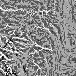
Набор данных «Физиография» представляет собой пространственное пересечение слоев данных о формах рельефа (доступен в EE как ERGo/1_0/US/landforms) и литологии (доступен в EE как ERGo/1_0/US/lithology). Он предоставляет 247 уникальных комбинаций из 270 возможных. Значения для каждого типа формируются путем конкатенации типов форм рельефа и литологии (например, 1101 — это форма рельефа «Пик/хребет» на «карбонатной» литологии). Этот слой данных иногда называют характеризующим «грани рельефа».
Слой рельефа основан на цифровой модели рельефа США (ЦМР) с разрешением 10 м, предоставленной Геологической службой США (доступна в Европе как USGS/NED). Слой литологии не основан ни на одной ЦМР.
Данный набор данных предоставлен только для США, поскольку имеется слой данных о литологии, хотя эти данные, вероятно, доступны и для других стран.
Группы
Группы
Размер пикселя: 90 метров (все диапазоны)
| Имя | Мин | Макс | Размер пикселя | Описание |
|---|---|---|---|---|
constant | 1100 | 4220 | 90 метров | Пересечение форм рельефа и литологии |
Условия эксплуатации
Условия эксплуатации
Цитаты
Теобальд, Д.М., Харрисон-Атлас, Д., Монахан, В.Б., и Альбано, К.М. (2015). Экологически значимые карты рельефа и физиографического разнообразия для планирования адаптации к изменению климата. PloS one, 10(12), e0143619
Исследуйте мир с помощью Earth Engine.
Редактор кода (JavaScript)
var dataset = ee.Image('CSP/ERGo/1_0/US/physiography');
var physiography = dataset.select('constant');
var physiographyVis = {
  min: 1100.0,
  max: 4220.0,
};
Map.setCenter(-105.4248, 40.5242, 8);
Map.addLayer(physiography, physiographyVis, 'Physiography');