Page Summary
-
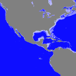
This dataset provides static bathymetry, or sea floor depth in meters, for the Global Ocean Waves Analysis and Forecast system.
-
The bathymetry data is generated using the MFWAM wave model, based on ETOPO2/NOAA 2-minute gridded global topography data.
-
The dataset is available under a Service Level Agreement (SLA) with the E.U. Copernicus Marine Environment Monitoring Service.
-
This dataset can be explored and analyzed using the Google Earth Engine platform.
- Dataset Availability
- 2022-06-01T00:00:00Z–2001-09-01T00:00:00Z
- Dataset Producer
- Copernicus Marine Service Global Ocean Waves and Forecasts
- Tags
Description
Static bathymetry for the Global Ocean Waves Analysis and Forecast system. This dataset provides the sea floor depth in meters.
The global wave system of Meteo-France is based on the wave model MFWAM which is a third generation wave model. MFWAM uses the computing code ECWAM-IFS-38R2 with dissipation terms developed by Ardhuin et al. (2010). The model MFWAM was upgraded on November 2014 thanks to improvements obtained from the European research project 'my wave' (Janssen et al. 2014).
The model mean bathymetry is generated by using 2-minute gridded global topography data ETOPO2/NOAA. Native model grid is irregular with decreasing distance in the latitudinal direction close to the poles. At the equator the distance in the latitudinal direction is more or less fixed with grid size 1/10 degrees. The operational model MFWAM is driven by 6-hourly analysis and 3-hourly forecasted winds from the IFS-ECMWF atmospheric system. The wave spectrum is discretized in 24 directions and 30 frequencies starting from 0.035 Hz to 0.58 Hz. The model MFWAM uses the assimilation of altimeters with a time step of 6 hours. The global wave system provides analysis 4 times a day, and a forecast of 10 days at 0:00 UTC. The wave model MFWAM uses the partitioning to split the swell spectrum in primary and secondary swells.
GLOBAL_ANALYSISFORECAST_WAV_001_027, implemented by Mercator Ocean International. It provides a comprehensive overview of the global ocean wave analysis and forecasting system produced by Meteo-France. The system delivers aggregated analyses and a 10-day forecast, updated twice-daily, including various integrated wave parameters such as significant wave height, period, direction, and Stokes drift for both the total wave spectrum and partitioned waves (wind wave, primary and secondary swell).
Bands
Bands
Pixel size: 9276.62 meters (all bands)
| Name | Units | Pixel Size | Description |
|---|---|---|---|
deptho |
m | 9276.62 meters | Sea floor depth |
Terms of Use
Terms of Use
This dataset is released for use under Service Level Agreement (SLA), using the acronym "CMEMS" or the shortened name "Copernicus Marine Service" both denote the E.U. Copernicus Marine Environment Monitoring Service. Highlights and key features of the licence are provided in this document License
Citations
E.U. Copernicus Marine Service Information (2024). Global Ocean Waves Analysis and Forecast. doi.org/10.48670/moi-00017
Explore with Earth Engine
Code Editor (JavaScript)
var dataset = ee.ImageCollection("COPERNICUS/MARINE/WAV/ANFC_0_083DEG_STATIC").first();
var seaFloorDepth = dataset.select('deptho');
var seaFloorDepthVis = {
  min: 0,
  max: 300,
  palette: ['ccccff', '0000ff'],
};
Map.setCenter(0, 0, 2);
Map.addLayer(seaFloorDepth, seaFloorDepthVis, 'Sea Floor Depth');