The Global Ocean Colour (Copernicus-GlobColour) dataset is a Bio-Geo-Chemical
(BGC) product developed by ACRI-ST. Derived from multiple satellite sources
like SeaWiFS, MODIS, and OLCI. It provides a comprehensive range of
oceanographic variables, including: Chlorophyll (CHL),
Phytoplankton Functional types and sizes (PFT), Primary Production (PP),
Suspended Matter (SPM), Secchi Transparency Depth (ZSD),
Diffuse Attenuation (KD490), Particulate Backscattering (BBP),
Absorption Coefficient (CDM), Reflectance (RRS) and more.
This dataset provides a global record of marine remote sensing reflectance.
This L4 product integrates data from multiple satellite sensors to provide a
consistent and high-quality dataset with a 4 km spatial resolution. The marine
reflectance data, which measures the light leaving the ocean surface at
various wavelengths, is a fundamental ocean color parameter used to derive
other biogeochemical properties like chlorophyll-a concentration and total
suspended matter.
Remote Sensing Reflectance at 412 nm - The uncertainty as measured in
hundredths of a percent (e.g., a value of 5000 means 50%)..
RRS443
sr^-1
meters
Remote Sensing Reflectance at 443 nm
RRS443_uncertainty
%
meters
Remote Sensing Reflectance at 443 nm - The uncertainty as measured in
hundredths of a percent (e.g., a value of 5000 means 50%).
RRS490
sr^-1
meters
Remote Sensing Reflectance at 490 nm
RRS490_uncertainty
%
meters
Remote Sensing Reflectance at 490 nm - The uncertainty as measured in
hundredths of a percent (e.g., a value of 5000 means 50%).
RRS555
sr^-1
meters
Remote Sensing Reflectance at 555 nm
RRS555_uncertainty
%
meters
Remote Sensing Reflectance at 555 nm - The uncertainty as measured in
hundredths of a percent (e.g., a value of 5000 means 50%).
RRS670
sr^-1
meters
Remote Sensing Reflectance at 670 nm
RRS670_uncertainty
%
meters
Remote Sensing Reflectance at 670 nm - The uncertainty as measured in
hundredths of a percent (e.g., a value of 5000 means 50%).
flags
meters
Land water mask bit.
0: Water
1: Land
Terms of Use
Terms of Use
This dataset is released for use under Service Level Agreement (SLA),
using the acronym "CMEMS" or the shortened name "Copernicus Marine Service"
both denote the E.U. Copernicus Marine Environment Monitoring Service.
Highlights and key features of the licence are provided in this document
License
Citations
Citations:
Copernicus Global Ocean Colour: Global Ocean Satellite Observations,
ACRI-ST company (Sophia Antipolis, France) is providing Bio-Geo-Chemical
(BGC) products based on the Copernicus-GlobColour processor.
doi:10.48670/moi-00279
The Global Ocean Colour (Copernicus-GlobColour) dataset is a Bio-Geo-Chemical (BGC) product developed by ACRI-ST. Derived from multiple satellite sources like SeaWiFS, MODIS, and OLCI. It provides a comprehensive range of oceanographic variables, including: Chlorophyll (CHL), Phytoplankton Functional types and sizes (PFT), Primary Production (PP), Suspended Matter (SPM), Secchi Transparency Depth …
[[["Easy to understand","easyToUnderstand","thumb-up"],["Solved my problem","solvedMyProblem","thumb-up"],["Other","otherUp","thumb-up"]],[["Missing the information I need","missingTheInformationINeed","thumb-down"],["Too complicated / too many steps","tooComplicatedTooManySteps","thumb-down"],["Out of date","outOfDate","thumb-down"],["Samples / code issue","samplesCodeIssue","thumb-down"],["Other","otherDown","thumb-down"]],[],[],[],null,["# Global Ocean Colour: Bio-Geo-Chemical, L4, from Satellite Observations, Reflectance, Multi-Sensor 4KM\n\nDataset Availability\n: 2023-04-01T00:00:00Z--2025-06-01T00:00:00Z\n\nDataset Provider\n:\n\n\n [Copernicus](https://doi.org/10.48670/moi-00279)\n\nCadence\n: 1 Month\n\nTags\n:\n[copernicus](/earth-engine/datasets/tags/copernicus) [marine](/earth-engine/datasets/tags/marine) [oceans](/earth-engine/datasets/tags/oceans) \n\n#### Description\n\nThe Global Ocean Colour (Copernicus-GlobColour) dataset is a Bio-Geo-Chemical\n(BGC) product developed by ACRI-ST. Derived from multiple satellite sources\nlike SeaWiFS, MODIS, and OLCI. It provides a comprehensive range of\noceanographic variables, including: Chlorophyll (CHL),\nPhytoplankton Functional types and sizes (PFT), Primary Production (PP),\nSuspended Matter (SPM), Secchi Transparency Depth (ZSD),\nDiffuse Attenuation (KD490), Particulate Backscattering (BBP),\nAbsorption Coefficient (CDM), Reflectance (RRS) and more.\n\nThis dataset provides a global record of marine remote sensing reflectance.\nThis L4 product integrates data from multiple satellite sensors to provide a\nconsistent and high-quality dataset with a 4 km spatial resolution. The marine\nreflectance data, which measures the light leaving the ocean surface at\nvarious wavelengths, is a fundamental ocean color parameter used to derive\nother biogeochemical properties like chlorophyll-a concentration and total\nsuspended matter.\n\nDocumentation:\n\n- [User's Guide](https://documentation.marine.copernicus.eu/PUM/CMEMS-OC-PUM.pdf)\n\n- [Quality Information Document](https://documentation.marine.copernicus.eu/QUID/CMEMS-OC-QUID-009-101to104-111-113-116-118.pdf)\n\n- [Copernicus Marine Datastore](https://data.marine.copernicus.eu/products)\n\n### Bands\n\n\n**Pixel Size**\n\n4000 meters\n\n**Bands**\n\n| Name | Units | Pixel Size | Description |\n|----------------------|--------|------------|-----------------------------------------------------------------------------------------------------------------------------------|\n| `RRS412` | sr\\^-1 | meters | Remote Sensing Reflectance at 412 nm |\n| `RRS412_uncertainty` | % | meters | Remote Sensing Reflectance at 412 nm - The uncertainty as measured in hundredths of a percent (e.g., a value of 5000 means 50%).. |\n| `RRS443` | sr\\^-1 | meters | Remote Sensing Reflectance at 443 nm |\n| `RRS443_uncertainty` | % | meters | Remote Sensing Reflectance at 443 nm - The uncertainty as measured in hundredths of a percent (e.g., a value of 5000 means 50%). |\n| `RRS490` | sr\\^-1 | meters | Remote Sensing Reflectance at 490 nm |\n| `RRS490_uncertainty` | % | meters | Remote Sensing Reflectance at 490 nm - The uncertainty as measured in hundredths of a percent (e.g., a value of 5000 means 50%). |\n| `RRS555` | sr\\^-1 | meters | Remote Sensing Reflectance at 555 nm |\n| `RRS555_uncertainty` | % | meters | Remote Sensing Reflectance at 555 nm - The uncertainty as measured in hundredths of a percent (e.g., a value of 5000 means 50%). |\n| `RRS670` | sr\\^-1 | meters | Remote Sensing Reflectance at 670 nm |\n| `RRS670_uncertainty` | % | meters | Remote Sensing Reflectance at 670 nm - The uncertainty as measured in hundredths of a percent (e.g., a value of 5000 means 50%). |\n| `flags` | | meters | Land water mask bit. - 0: Water - 1: Land |\n\n### Terms of Use\n\n**Terms of Use**\n\nThis dataset is released for use under Service Level Agreement (SLA),\nusing the acronym \"CMEMS\" or the shortened name \"Copernicus Marine Service\"\nboth denote the E.U. Copernicus Marine Environment Monitoring Service.\nHighlights and key features of the licence are provided in this document\n[License](https://marine.copernicus.eu/user-corner/service-commitments-and-licence)\n\n### Citations\n\nCitations:\n\n- Copernicus Global Ocean Colour: Global Ocean Satellite Observations,\n ACRI-ST company (Sophia Antipolis, France) is providing Bio-Geo-Chemical\n (BGC) products based on the Copernicus-GlobColour processor.\n [doi:10.48670/moi-00279](https://doi.org/10.48670/moi-00279)\n\n### Explore with Earth Engine\n\n| **Important:** Earth Engine is a platform for petabyte-scale scientific analysis and visualization of geospatial datasets, both for public benefit and for business and government users. Earth Engine is free to use for research, education, and nonprofit use. To get started, please [register for Earth Engine access.](https://console.cloud.google.com/earth-engine)\n\n### 
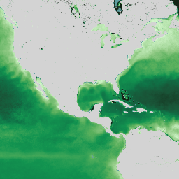
Code Editor (JavaScript)\n\n```javascript\nvar dataset =\n ee.ImageCollection('COPERNICUS/MARINE/OC_GLO_BGC/REFLECTANCE_MULTI_4KM')\n .filter(ee.Filter.date('2025-03-01', '2025-06-01'));\nvar RRS = dataset.select('RRS412').mean();\nvar RRSVis = {\n min: 0.001,\n max: 0.018,\n palette:\n ['D7F9D0', '91CA85', '5AB05D', '129450', '0F7347', '195437', '122414'],\n};\nMap.setCenter(71, 52, 2);\nMap.addLayer(RRS, RRSVis, 'Reflectance sensor');\n```\n[Open in Code Editor](https://code.earthengine.google.com/?scriptPath=Examples:Datasets/COPERNICUS/COPERNICUS_MARINE_OC_GLO_BGC_REFLECTANCE_MULTI_4KM) \n[Global Ocean Colour: Bio-Geo-Chemical, L4, from Satellite Observations, Reflectance, Multi-Sensor 4KM](/earth-engine/datasets/catalog/COPERNICUS_MARINE_OC_GLO_BGC_REFLECTANCE_MULTI_4KM) \nThe Global Ocean Colour (Copernicus-GlobColour) dataset is a Bio-Geo-Chemical (BGC) product developed by ACRI-ST. Derived from multiple satellite sources like SeaWiFS, MODIS, and OLCI. It provides a comprehensive range of oceanographic variables, including: Chlorophyll (CHL), Phytoplankton Functional types and sizes (PFT), Primary Production (PP), Suspended Matter (SPM), Secchi Transparency Depth ... \nCOPERNICUS/MARINE/OC_GLO_BGC/REFLECTANCE_MULTI_4KM, copernicus,marine,oceans \n2023-04-01T00:00:00Z/2025-06-01T00:00:00Z \n-90 -180 90 180 \nGoogle Earth Engine \nhttps://developers.google.com/earth-engine/datasets\n\n- [](https://doi.org/https://doi.org/10.48670/moi-00279)\n- [](https://doi.org/https://developers.google.com/earth-engine/datasets/catalog/COPERNICUS_MARINE_OC_GLO_BGC_REFLECTANCE_MULTI_4KM)"]]