- Dataset Producer
- Copernicus
- Tags
Description
The In Situ TAC is a distributed centre organized around 7 oceanographic regions: the global ocean and the 6 EUROGOOS regional alliances. It involves 14 partners from 11 countries in Europe. It doesn't deploy any observing system and relies on data, exclusively funded by other sources than Copernicus Marine Service.
Regarding the production of global ocean products like the present one, activities among partners are organized according to the expertise and background in data management for operational oceanography. Drifter data in this collection come from two main sources: near-surface velocity measurements (15 m depth) from the French project Coriolis, part of the DBCP's Global Drifter Program, and drifter data retrieved from the OGS Mediterranean drifter dataset. The latter includes raw data from various research institutions and international data centers, processed using techniques described in Menna et al. (2017, 2018). The drifters have varying drogue depths, mostly between 0 and 15 m, but ranging from 0 to 300 m.
For more details refer to this user manual
BigQuery Table Schema
Table Schema
| Name | Type | Description |
|---|---|---|
| TIME | DATETIME | datetime of the observation |
| TIME_QC | INT | Quality control flag for TIME.
Note that a valid value for the corresponding variable has a QC bit equal to 1, 2, 5, 7, or 8. |
| DEPTH | DOUBLE | Number of Depth levels |
| DEPH | DOUBLE | Depth of the observation. (m) |
| DEPH_QC | INT | Quality control flag for DEPH.
Note that a valid value for the corresponding variable has a QC bit equal to 1, 2, 5, 7, or 8. |
| TEMP | DOUBLE | Temperature 20-30 cm beneath the sea surface. (Degrees Celsius) |
| TEMP_QC | INT | Quality control flag for TEMP.
Note that a valid value for the corresponding variable has a QC bit equal to 1, 2, 5, 7, or 8. |
| EWCT | DOUBLE | West-East sea water velocity at the drogue depth from the drifter position (m/s) |
| EWCT_QC | INT | Quality control flag for EWCT.
Note that a valid value for the corresponding variable has a QC bit equal to 1, 2, 5, 7, or 8. |
| NSCT | DOUBLE | South-North sea water velocity at the drogue depth from the drifter position (m/s) |
| NSCT_QC | INT | Quality control flag for NSCT.
Note that a valid value for the corresponding variable has a QC bit equal to 1, 2, 5, 7, or 8. |
| WSTN_MODEL | DOUBLE | North component of the 6-hour integrated wind stress from ECMWF model interpolated at the drifter's position (N/m^2) |
| WSTN_MODEL_QC | DOUBLE | Quality control flag for WSTN_MODEL.
Note that a valid value for the corresponding variable has a QC bit equal to 1, 2, 5, 7, or 8. |
| WSTE_MODEL | DOUBLE | East component of the 6-hour integrated wind stress from ECMWF model interpolated at the drifter's position (N/m^2) |
| WSTE_MODEL_QC | INT | Quality control flag for WSTE_MODEL.
Note that a valid value for the corresponding variable has a QC bit equal to 1, 2, 5, 7, or 8. |
| WSPN_MODEL | DOUBLE | South-North 6-hour integrated 10-m wind component from ECMWF model interpolated at the drifter's position (m/s) |
| WSPN_MODEL_QC | INT | Quality control flag for WSPN_MODEL.
Note that a valid value for the corresponding variable has a QC bit equal to 1, 2, 5, 7, or 8. |
| WSPE_MODEL | DOUBLE | West-East 6-hour integrated 10-m wind component from ECMWF model interpolated at the drifter's position (m/s) |
| WSPE_MODEL_QC | INT | Quality control flag for WSPE_MODEL.
Note that a valid value for the corresponding variable has a QC bit equal to 1, 2, 5, 7, or 8. |
| EWCT_WS | DOUBLE | West-East wind slippage correction (m/s) |
| EWCT_WS_QC | INT | Quality control flag for EWCT_WS.
Note that a valid value for the corresponding variable has a QC bit equal to 1, 2, 5, 7, or 8. |
| NSCT_WS | DOUBLE | South-North wind slippage correction (m/s) |
| NSCT_WS_QC | DOUBLE | Quality control flag for NSCT_WS.
Note that a valid value for the corresponding variable has a QC bit equal to 1, 2, 5, 7, or 8. |
| WS_TYPE_OF_PROCESSING | INT | Wind slippage correction processing method (Dimensionless)
|
| PLATFORM_CODE | STRING | Platform code relative to each measurement |
| CURRENT_TEST | STRING | Tests of drogue loss results. It contains the 3 flags value for the 3 tests in a float format [SAW]
It's a three-character string where each character is one of the following digits:
|
| CURRENT_TEST_QC | INT | Quality control flag for CURRENT_TEST.
Note that a valid value for the corresponding variable has a QC bit equal to 1, 2, 5, 7, or 8. |
| DC_REFERENCE | STRING | Reference to the data center. |
| POSITION_QC | INT | Quality control flag for POSITION.
Note that a valid value for the corresponding variable has a QC bit equal to 1, 2, 5, 7, or 8. |
| TRAJECTORY | STRING | Trajectory identifier |
| geometry | GEOMETRY | Geographic location of the observation. |
Terms of Use
The data is provided free of charge by the Copernicus Marine Service. Users must acknowledge the Copernicus Marine Service as the data source when using the data. More details on the terms of use can be found on the Copernicus Marine Service website.
Terms of Use
Terms of Use
The data is provided free of charge by the Copernicus Marine Service. Users must acknowledge the Copernicus Marine Service as the data source when using the data. More details on the terms of use can be found on the Copernicus Marine Service website.
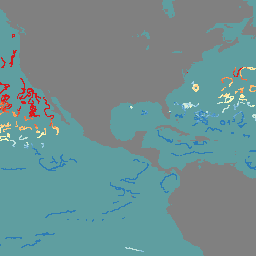
Explore with Earth Engine
Code Editor (JavaScript)
var dataset = ee.FeatureCollection.loadBigQueryTable("earth-engine-public-data.insitu_nrt_currents.drifter_latest")
                  .filter(ee.Filter.date('2025-04-01', '2025-05-01'));

var temps = dataset.select('TEMP');

var tempVis = {
  min: 18,
  max: 25,
  palette: ['d7191c', 'fdae61', 'ffffbf', 'abd9e9', '2c7bb6'],
};

// Create an empty image and paint the features onto it, coloring by 'TEMP'.
var image = ee.Image().float().paint({
  featureCollection: temps,
  color: 'TEMP',
  width: 8 // Point size
});

Map.setCenter(-100.5, 30.2, 3);
Map.addLayer(image, tempVis, 'Global INSITU Drifter TEMP');