- Dataset Producer
- Copernicus
- Tags
Description
The In Situ TAC is a distributed centre organized around 7 oceanographic regions: the global ocean and the 6 EUROGOOS regional alliances. It involves 14 partners from 11 countries in Europe. It doesn't deploy any observing system and relies on data, exclusively funded by other sources than Copernicus Marine Service.
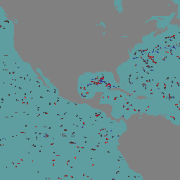
This dataset is derived from the original trajectory data from Argo GDAC (Global Data Assembly Center). In 2020, the GDAC distributes data from more than 15,000 Argo floats. Deep ocean current is calculated from floats drift at parking depth, surface current is calculated from float surface drift.
For more details refer to this user manual
BigQuery Table Schema
Table Schema
| Name | Type | Description |
|---|---|---|
| TIME | DATETIME | Datetime of the observation |
| DEPTH | DOUBLE | Number of depth levels |
| LATITUDE | DOUBLE | Latitude of the observation |
| LONGITUDE | DOUBLE | Longitude of the observation |
| PRES | DOUBLE | Representative pressure of the current observation. Can be 0 or parking depth pressure (decibar). |
| TRAJECTORY | STRING | Trajectory identifier |
| PRES_QC | INT | Quality control flag for PRES.
Note that a valid value for the corresponding variable has a QC bit equal to 1, 2, 5, 7, or 8. |
| EWCT | DOUBLE | West-East sea water velocity at the representative pressure (m/s) |
| EWCT_QC | INT | Quality control flag for EWCT.
Note that a valid value for the corresponding variable has a QC bit equal to 1, 2, 5, 7, or 8. |
| NSCT | DOUBLE | South-North sea water velocity at the representative pressure (m/s) |
| NSCT_QC | INT | Quality control flag for NSCT.
Note that a valid value for the corresponding variable has a QC bit equal to 1, 2, 5, 7, or 8. |
| TIME_QC | INT | Quality control flag for TIME.
Note that a valid value for the corresponding variable has a QC bit equal to 1, 2, 5, 7, or 8. |
| POSITION_QC | INT | Quality control flag for POSITION.
Note that a valid value for the corresponding variable has a QC bit equal to 1, 2, 5, 7, or 8. |
| CYCLE_NUMBER | DOUBLE | Cycle number of the Argo float |
| GROUNDED | STRING | Indicates the best estimate of whether the float touched the ground for that cycle. The conventions are described below:
|
| DURATION | DOUBLE | Duration of measurement |
| geometry | GEOMETRY | Geographic location of the observation |
Terms of Use
The data is provided free of charge by the Copernicus Marine Service. Users must acknowledge the Copernicus Marine Service as the data source when using the data. More details on the terms of use can be found on the Copernicus Marine Service website.
Terms of Use
Terms of Use
The data is provided free of charge by the Copernicus Marine Service. Users must acknowledge the Copernicus Marine Service as the data source when using the data. More details on the terms of use can be found on the Copernicus Marine Service website.
Explore with Earth Engine
Code Editor (JavaScript)
var dataset = ee.FeatureCollection.loadBigQueryTable("earth-engine-public-data.insitu_nrt_currents.argo_latest")
                  .filter(ee.Filter.date('2025-04-01', '2025-05-01'));

dataset = dataset.map(function(f) {
  var val = ee.Number(f.get('EWCT')).float();
  return f.buffer(8000) // 8km radius circles
          .set('EWCT', val);
});


var image = dataset.reduceToImage({
  properties: ['EWCT'],
  reducer: ee.Reducer.first()
});

var visParams = {
  min: -0.5,
  max: 0.5,
  palette: ['a50026', 'd73027', '333333', '4575b4', '313695'],
};

Map.setCenter(-100.5, 30.2, 3);
Map.addLayer(image, visParams, 'Global INSITU Argo EWCT');