- Dataset Availability
- 2022-01-01T00:00:00Z–2025-09-26T00:00:00Z
- Dataset Producer
- Copernicus
- Cadence
- 1 Day
- Tags
Description
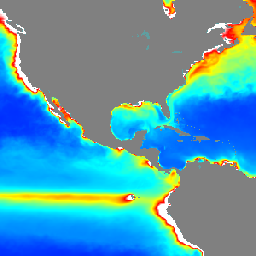
The Operational Mercator Ocean biogeochemical global ocean analysis and
forecast system at 1/4 degree is providing 10 days of 3D global ocean
forecasts updated weekly. The time series is aggregated in time, in order
to reach a two full year's time series sliding window. This product
includes daily and monthly mean files of biogeochemical parameters
(chlorophyll, nitrate, phosphate, silicate, dissolved oxygen, dissolved
iron, primary production, phytoplankton, zooplankton, PH, and surface
partial pressure of carbon dioxide) over the global ocean. The global
ocean output files are displayed with a 1/4 degree horizontal resolution
with regular longitude/latitude equirectangular projection.
These products are provided on 50 vertical levels with
depths ranging from 0.49m to 5727.92m.
This dataset consists of total chlorophyll and
total phytoplankton concentrations.
Bands
Bands
Pixel size: 27750 meters (all bands)
| Name | Units | Min | Max | Pixel Size | Description |
|---|---|---|---|---|---|
chl_depth1 |
mg/m^3 | 0* | 27* | 27750 meters | Total Chlorophyll (depth 1, 0.4940m) |
chl_depth2 |
mg/m^3 | 0* | 27* | 27750 meters | Total Chlorophyll (depth 2, 1.5414m) |
chl_depth3 |
mg/m^3 | 0* | 27* | 27750 meters | Total Chlorophyll (depth 3, 2.6457m) |
chl_depth4 |
mg/m^3 | 0* | 27* | 27750 meters | Total Chlorophyll (depth 4, 3.8195m) |
chl_depth5 |
mg/m^3 | 0* | 27* | 27750 meters | Total Chlorophyll (depth 5, 5.0782m) |
chl_depth6 |
mg/m^3 | 0* | 27* | 27750 meters | Total Chlorophyll (depth 6, 6.4406m) |
chl_depth7 |
mg/m^3 | 0* | 27* | 27750 meters | Total Chlorophyll (depth 7, 7.9296m) |
chl_depth8 |
mg/m^3 | 0* | 27* | 27750 meters | Total Chlorophyll (depth 8, 9.5730m) |
chl_depth9 |
mg/m^3 | 0* | 27* | 27750 meters | Total Chlorophyll (depth 9, 11.4050m) |
chl_depth10 |
mg/m^3 | 0* | 27* | 27750 meters | Total Chlorophyll (depth 10, 13.4671m) |
chl_depth11 |
mg/m^3 | 0* | 27* | 27750 meters | Total Chlorophyll (depth 11, 15.8101m) |
chl_depth12 |
mg/m^3 | 0* | 27* | 27750 meters | Total Chlorophyll (depth 12, 18.4956m) |
chl_depth13 |
mg/m^3 | 0* | 27* | 27750 meters | Total Chlorophyll (depth 13, 21.5988m) |
chl_depth14 |
mg/m^3 | 0* | 27* | 27750 meters | Total Chlorophyll (depth 14, 25.2114m) |
chl_depth15 |
mg/m^3 | 0* | 27* | 27750 meters | Total Chlorophyll (depth 15, 29.4447m) |
chl_depth16 |
mg/m^3 | 0* | 27* | 27750 meters | Total Chlorophyll (depth 16, 34.4342m) |
chl_depth17 |
mg/m^3 | 0* | 27* | 27750 meters | Total Chlorophyll (depth 17, 40.3441m) |
chl_depth18 |
mg/m^3 | 0* | 27* | 27750 meters | Total Chlorophyll (depth 18, 47.3737m) |
chl_depth19 |
mg/m^3 | 0* | 27* | 27750 meters | Total Chlorophyll (depth 19, 55.7643m) |
chl_depth20 |
mg/m^3 | 0* | 27* | 27750 meters | Total Chlorophyll (depth 20, 65.8073m) |
chl_depth21 |
mg/m^3 | 0* | 27* | 27750 meters | Total Chlorophyll (depth 21, 77.8539m) |
chl_depth22 |
mg/m^3 | 0* | 27* | 27750 meters | Total Chlorophyll (depth 22, 92.3261m) |
chl_depth23 |
mg/m^3 | 0* | 27* | 27750 meters | Total Chlorophyll (depth 23, 109.7293m) |
chl_depth24 |
mg/m^3 | 0* | 27* | 27750 meters | Total Chlorophyll (depth 24, 130.6660m) |
chl_depth25 |
mg/m^3 | 0* | 27* | 27750 meters | Total Chlorophyll (depth 25, 155.8507m) |
chl_depth26 |
mg/m^3 | 0* | 27* | 27750 meters | Total Chlorophyll (depth 26, 186.1256m) |
chl_depth27 |
mg/m^3 | 0* | 27* | 27750 meters | Total Chlorophyll (depth 27, 222.4752m) |
chl_depth28 |
mg/m^3 | 0* | 27* | 27750 meters | Total Chlorophyll (depth 28, 266.0403m) |
chl_depth29 |
mg/m^3 | 0* | 27* | 27750 meters | Total Chlorophyll (depth 29, 318.1274m) |
chl_depth30 |
mg/m^3 | 0* | 27* | 27750 meters | Total Chlorophyll (depth 30, 380.2130m) |
chl_depth31 |
mg/m^3 | 0* | 27* | 27750 meters | Total Chlorophyll (depth 31, 453.9377m) |
chl_depth32 |
mg/m^3 | 0* | 27* | 27750 meters | Total Chlorophyll (depth 32, 541.0889m) |
chl_depth33 |
mg/m^3 | 0* | 27* | 27750 meters | Total Chlorophyll (depth 33, 643.5668m) |
chl_depth34 |
mg/m^3 | 0* | 27* | 27750 meters | Total Chlorophyll (depth 34, 763.3331m) |
chl_depth35 |
mg/m^3 | 0* | 27* | 27750 meters | Total Chlorophyll (depth 35, 902.3393m) |
chl_depth36 |
mg/m^3 | 0* | 27* | 27750 meters | Total Chlorophyll (depth 36, 1062.4397m) |
chl_depth37 |
mg/m^3 | 0* | 27* | 27750 meters | Total Chlorophyll (depth 37, 1245.2911m) |
chl_depth38 |
mg/m^3 | 0* | 27* | 27750 meters | Total Chlorophyll (depth 38, 1452.2510m) |
chl_depth39 |
mg/m^3 | 0* | 27* | 27750 meters | Total Chlorophyll (depth 39, 1684.2844m) |
chl_depth40 |
mg/m^3 | 0* | 27* | 27750 meters | Total Chlorophyll (depth 40, 1941.8934m) |
chl_depth41 |
mg/m^3 | 0* | 27* | 27750 meters | Total Chlorophyll (depth 41, 2225.0779m) |
chl_depth42 |
mg/m^3 | 0* | 27* | 27750 meters | Total Chlorophyll (depth 42, 2533.3362m) |
chl_depth43 |
mg/m^3 | 0* | 27* | 27750 meters | Total Chlorophyll (depth 43, 2865.7026m) |
chl_depth44 |
mg/m^3 | 0* | 27* | 27750 meters | Total Chlorophyll (depth 44, 3220.8203m) |
chl_depth45 |
mg/m^3 | 0* | 27* | 27750 meters | Total Chlorophyll (depth 45, 3597.0320m) |
chl_depth46 |
mg/m^3 | 0* | 27* | 27750 meters | Total Chlorophyll (depth 46, 3992.4839m) |
chl_depth47 |
mg/m^3 | 0* | 27* | 27750 meters | Total Chlorophyll (depth 47, 4405.2241m) |
chl_depth48 |
mg/m^3 | 0* | 27* | 27750 meters | Total Chlorophyll (depth 48, 4833.2905m) |
chl_depth49 |
mg/m^3 | 0* | 27* | 27750 meters | Total Chlorophyll (depth 49, 5274.7842m) |
chl_depth50 |
mg/m^3 | 0* | 27* | 27750 meters | Total Chlorophyll (depth 50, 5727.9165m) |
phyc_depth1 |
mmol/m^3 | 0* | 117* | 27750 meters | Total Phytoplankton (depth 1, 0.4940m) |
phyc_depth2 |
mmol/m^3 | 0* | 117* | 27750 meters | Total Phytoplankton (depth 2, 1.5414m) |
phyc_depth3 |
mmol/m^3 | 0* | 117* | 27750 meters | Total Phytoplankton (depth 3, 2.6457m) |
phyc_depth4 |
mmol/m^3 | 0* | 117* | 27750 meters | Total Phytoplankton (depth 4, 3.8195m) |
phyc_depth5 |
mmol/m^3 | 0* | 117* | 27750 meters | Total Phytoplankton (depth 5, 5.0782m) |
phyc_depth6 |
mmol/m^3 | 0* | 117* | 27750 meters | Total Phytoplankton (depth 6, 6.4406m) |
phyc_depth7 |
mmol/m^3 | 0* | 117* | 27750 meters | Total Phytoplankton (depth 7, 7.9296m) |
phyc_depth8 |
mmol/m^3 | 0* | 117* | 27750 meters | Total Phytoplankton (depth 8, 9.5730m) |
phyc_depth9 |
mmol/m^3 | 0* | 117* | 27750 meters | Total Phytoplankton (depth 9, 11.4050m) |
phyc_depth10 |
mmol/m^3 | 0* | 117* | 27750 meters | Total Phytoplankton (depth 10, 13.4671m) |
phyc_depth11 |
mmol/m^3 | 0* | 117* | 27750 meters | Total Phytoplankton (depth 11, 15.8101m) |
phyc_depth12 |
mmol/m^3 | 0* | 117* | 27750 meters | Total Phytoplankton (depth 12, 18.4956m) |
phyc_depth13 |
mmol/m^3 | 0* | 117* | 27750 meters | Total Phytoplankton (depth 13, 21.5988m) |
phyc_depth14 |
mmol/m^3 | 0* | 117* | 27750 meters | Total Phytoplankton (depth 14, 25.2114m) |
phyc_depth15 |
mmol/m^3 | 0* | 117* | 27750 meters | Total Phytoplankton (depth 15, 29.4447m) |
phyc_depth16 |
mmol/m^3 | 0* | 117* | 27750 meters | Total Phytoplankton (depth 16, 34.4342m) |
phyc_depth17 |
mmol/m^3 | 0* | 117* | 27750 meters | Total Phytoplankton (depth 17, 40.3441m) |
phyc_depth18 |
mmol/m^3 | 0* | 117* | 27750 meters | Total Phytoplankton (depth 18, 47.3737m) |
phyc_depth19 |
mmol/m^3 | 0* | 117* | 27750 meters | Total Phytoplankton (depth 19, 55.7643m) |
phyc_depth20 |
mmol/m^3 | 0* | 117* | 27750 meters | Total Phytoplankton (depth 20, 65.8073m) |
phyc_depth21 |
mmol/m^3 | 0* | 117* | 27750 meters | Total Phytoplankton (depth 21, 77.8539m) |
phyc_depth22 |
mmol/m^3 | 0* | 117* | 27750 meters | Total Phytoplankton (depth 22, 92.3261m) |
phyc_depth23 |
mmol/m^3 | 0* | 117* | 27750 meters | Total Phytoplankton (depth 23, 109.7293m) |
phyc_depth24 |
mmol/m^3 | 0* | 117* | 27750 meters | Total Phytoplankton (depth 24, 130.6660m) |
phyc_depth25 |
mmol/m^3 | 0* | 117* | 27750 meters | Total Phytoplankton (depth 25, 155.8507m) |
phyc_depth26 |
mmol/m^3 | 0* | 117* | 27750 meters | Total Phytoplankton (depth 26, 186.1256m) |
phyc_depth27 |
mmol/m^3 | 0* | 117* | 27750 meters | Total Phytoplankton (depth 27, 222.4752m) |
phyc_depth28 |
mmol/m^3 | 0* | 117* | 27750 meters | Total Phytoplankton (depth 28, 266.0403m) |
phyc_depth29 |
mmol/m^3 | 0* | 117* | 27750 meters | Total Phytoplankton (depth 29, 318.1274m) |
phyc_depth30 |
mmol/m^3 | 0* | 117* | 27750 meters | Total Phytoplankton (depth 30, 380.2130m) |
phyc_depth31 |
mmol/m^3 | 0* | 117* | 27750 meters | Total Phytoplankton (depth 31, 453.9377m) |
phyc_depth32 |
mmol/m^3 | 0* | 117* | 27750 meters | Total Phytoplankton (depth 32, 541.0889m) |
phyc_depth33 |
mmol/m^3 | 0* | 117* | 27750 meters | Total Phytoplankton (depth 33, 643.5668m) |
phyc_depth34 |
mmol/m^3 | 0* | 117* | 27750 meters | Total Phytoplankton (depth 34, 763.3331m) |
phyc_depth35 |
mmol/m^3 | 0* | 117* | 27750 meters | Total Phytoplankton (depth 35, 902.3393m) |
phyc_depth36 |
mmol/m^3 | 0* | 117* | 27750 meters | Total Phytoplankton (depth 36, 1062.4397m) |
phyc_depth37 |
mmol/m^3 | 0* | 117* | 27750 meters | Total Phytoplankton (depth 37, 1245.2911m) |
phyc_depth38 |
mmol/m^3 | 0* | 117* | 27750 meters | Total Phytoplankton (depth 38, 1452.2510m) |
phyc_depth39 |
mmol/m^3 | 0* | 117* | 27750 meters | Total Phytoplankton (depth 39, 1684.2844m) |
phyc_depth40 |
mmol/m^3 | 0* | 117* | 27750 meters | Total Phytoplankton (depth 40, 1941.8934m) |
phyc_depth41 |
mmol/m^3 | 0* | 117* | 27750 meters | Total Phytoplankton (depth 41, 2225.0779m) |
phyc_depth42 |
mmol/m^3 | 0* | 117* | 27750 meters | Total Phytoplankton (depth 42, 2533.3362m) |
phyc_depth43 |
mmol/m^3 | 0* | 117* | 27750 meters | Total Phytoplankton (depth 43, 2865.7026m) |
phyc_depth44 |
mmol/m^3 | 0* | 117* | 27750 meters | Total Phytoplankton (depth 44, 3220.8203m) |
phyc_depth45 |
mmol/m^3 | 0* | 117* | 27750 meters | Total Phytoplankton (depth 45, 3597.0320m) |
phyc_depth46 |
mmol/m^3 | 0* | 117* | 27750 meters | Total Phytoplankton (depth 46, 3992.4839m) |
phyc_depth47 |
mmol/m^3 | 0* | 117* | 27750 meters | Total Phytoplankton (depth 47, 4405.2241m) |
phyc_depth48 |
mmol/m^3 | 0* | 117* | 27750 meters | Total Phytoplankton (depth 48, 4833.2905m) |
phyc_depth49 |
mmol/m^3 | 0* | 117* | 27750 meters | Total Phytoplankton (depth 49, 5274.7842m) |
phyc_depth50 |
mmol/m^3 | 0* | 117* | 27750 meters | Total Phytoplankton (depth 50, 5727.9165m) |
Terms of Use
Terms of Use
The data is provided free of charge by the Copernicus Marine Service. Users must acknowledge the Copernicus Marine Service as the data source when using the data. More details on the terms of use can be found on the Copernicus Marine Service website.
Citations
E.U. Copernicus Marine Service Information. https://doi.org/10.48670/moi-00015
Explore with Earth Engine
Code Editor (JavaScript)
var dataset = ee.ImageCollection("COPERNICUS/MARINE/GLOBAL_ANALYSISFORECAST_BGC_001_028/PFT")
                  .filter(ee.Filter.date('2024-01-01', '2025-01-01'));
var chl = dataset.select('chl_depth1');
var chlVis = {
  min: 0,
  max: 1,
  palette: ['0000ff', '00ffff', 'ffff00', 'ff0000', 'ffffff'],
};
Map.setCenter(-140.5, 52.2, 2);
Map.addLayer(chl, chlVis, 'Global BGC PFT Forecast');