Page Summary
-
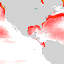
This dataset provides a 10-day forecast of surface partial pressure of carbon dioxide over the global ocean, updated weekly.
-
The data is available from January 1, 2022, to September 19, 2025, with a daily cadence and 1/4 degree horizontal resolution.
-
Users must acknowledge the Copernicus Marine Service as the data source and adhere to their terms of use.
-
The dataset is part of the Copernicus Global Ocean Bio-Geo-Chemical Analysis and Forecast system.
- Dataset Availability
- 2022-01-01T00:00:00Z–2025-09-19T00:00:00Z
- Dataset Producer
- Copernicus
- Cadence
- 1 Day
- Tags
Description
The Operational Mercator Ocean biogeochemical global ocean analysis and
forecast system at 1/4 degree is providing 10 days of 3D global ocean
forecasts updated weekly. The time series is aggregated in time, in order
to reach a two full year's time series sliding window. This product
includes daily and monthly mean files of biogeochemical parameters
(chlorophyll, nitrate, phosphate, silicate, dissolved oxygen, dissolved
iron, primary production, phytoplankton, zooplankton, PH, and surface
partial pressure of carbon dioxide) over the global ocean. The global
ocean output files are displayed with a 1/4 degree horizontal resolution
with regular longitude/latitude equirectangular projection.
This dataset consists of surface partial pressure
of carbon dioxide.
Bands
Bands
Pixel size: 27750 meters (all bands)
| Name | Units | Min | Max | Pixel Size | Description |
|---|---|---|---|---|---|
spco2_depth1 |
Pa | -14* | 1460* | 27750 meters | Surface Partial Pressure of Carbon Dioxide |
Terms of Use
Terms of Use
The data is provided free of charge by the Copernicus Marine Service. Users must acknowledge the Copernicus Marine Service as the data source when using the data. More details on the terms of use can be found on the Copernicus Marine Service website.
Citations
E.U. Copernicus Marine Service Information. https://doi.org/10.48670/moi-00015
Explore with Earth Engine
Code Editor (JavaScript)
var dataset = ee.ImageCollection("COPERNICUS/MARINE/GLOBAL_ANALYSISFORECAST_BGC_001_028/CO2")
                  .filter(ee.Filter.date('2022-01-01', '2023-01-01'));
var spco2 = dataset.select('spco2_depth1');
var spco2Vis = {
  min: 20,
  max: 40,
  palette: ['0000ff', '00ffff', 'ffff00', 'ff0000', 'ffffff'],
};
Map.setCenter(-140.5, 52.2, 2);
Map.addLayer(spco2, spco2Vis, 'Global BGC CO2 Forecast');