- Dataset Availability
- 2007-01-01T00:00:00Z–2009-11-26T23:59:59Z
- Dataset Producer
- Google/CNES
- Tags
Description
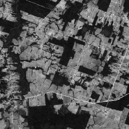
This collection contains the raw panchromatic (PAN) bands from the SPOT 2, 4, and 5 satellites for Brazil circa 2008. The panchromatic sensor provides the highest native spatial resolution of the missions, capturing light across a broad visible spectrum (0.51-0.73 µm for SPOT 2, 0.61-0.68 µm for SPOT 4, and 0.48-0.71 µm for SPOT 5). These bands are intended for advanced photogrammetric analysis and custom fusion workflows. Assets from SPOT 5 have a pixel size of 5m and assets from SPOT 2 and 4 have a pixel size of 10m.
Data access
To access this dataset, please fill out the request form.
Bands
Bands
Pixel size: 10 meters (all bands)
| Name | Units | Min | Max | Pixel Size | Description |
|---|---|---|---|---|---|
P |
dn | 0* | 255* | 10 meters | Panchromatic |
Image Properties
Image Properties
| Name | Type | Description |
|---|---|---|
| cloud_cover | DOUBLE | Scene-wide cloud cover estimate |
| grid_reference | STRING | The K-J grid reference identifies the nominal scene center, where K is the column and J is the row of the SPOT Grid Reference System (GRS). |
| high_quality | STRING | Set to TRUE for all images. |
| incidence_angle | DOUBLE | Incidence angle |
| instrument | STRING | Imaging instrument |
| job_id | STRING | Provider-set field denoting unique identifier for processing job. |
| nadir_lat | DOUBLE | Nadir latitude |
| nadir_lon | DOUBLE | Nadir longitude |
| pixel_size_meters | DOUBLE | Nominal scale |
| processing_level | STRING | Indicates the level of radiometric and geometric correction applied. Possible values: 1A (radiometric only) |
| product_id | STRING | Scene identifier |
| production_date | STRING | Date of processing. |
| satellite | STRING | Source satellite: "SPOT2", "SPOT4", or "SPOT5" |
| satellite_altitude | DOUBLE | Satellite orbit altitude |
| sensor_gain_number | DOUBLE | Calibration coefficient for converting DNs to radiance for sensor |
| sensor_gain_value | DOUBLE | Calibration coefficient for converting DNs to radiance for sensor |
| software | STRING | Processing software |
| source_id | STRING | Dataset_Sources/Source_Information/SOURCE_ID |
| sun_azimuth | DOUBLE | Sun azimuth |
| sun_elevation | DOUBLE | Sun elevation |
| viewing_angle | DOUBLE | Viewing angle |
| P_bias | DOUBLE | Calibration coefficient for converting DNs to radiance for panchromatic band |
| P_gain | DOUBLE | Calibration coefficient for converting DNs to radiance for panchromatic band |
| P_irradiance | DOUBLE | Per-band solar irradiance, essential for TOA reflectance calculations for panchromatic band |
Terms of Use
Terms of Use
Use of this dataset is subject to the Brazil Forest Imagery Dataset 2008 license agreement and requires the following attribution:
“Google LLC, Brazil Forest Imagery Dataset 2008 created from circa 2008 SPOT images acquired by CNES's Spot World Heritage Programme.”
Contains modified imagery from SPOT satellites made available by the CNES SPOT World Heritage Programme (https://regards.cnes.fr/html/swh/Home-swh3.html).
Explore with Earth Engine
Code Editor (JavaScript)
// To access this dataset, fill out the form: https://forms.gle/jQmCbWgarjENQBYz6

var collection = ee.ImageCollection('AIRBUS/SPOT_2_4_5/BRAZIL/2007_2009/PAN/V1');

var image = collection.first();
Map.centerObject(image, 13);
Map.addLayer(image, {min: 0, max: 200}, 'Panchromatic');