
Attributed contrail segments for a specific list of flights.
Data format
Requests for attributed contrails contains data with the following structure:
| JSON representation |
|---|
{
"attributions": [
{
object ( |
| Fields | |
|---|---|
attributions[] |
A list of attributions one for each resource name specified in the |
Attribution
Represents an aggregated contrail event for a specific flight summarizing all attributed contrail segments (e.g., total kilometers and energy).
| JSON representation |
|---|
{ "name": string, "flightDetails": { object ( |
| Fields | |
|---|---|
name |
Identifier. The resource name of the flight. Format: Components:
|
flightDetails |
The detail information for this flight. |
contrail |
Aggregated contrail attributes for the entire flight. This sums up the contrail attributes from all attributed segments. State interpretation (within a found flight):
|
segments[] |
Per-segment contrail attributions. Each entry represents a distinct time interval of the flight to which contrail(s) were attributed. |
FlightDetails
Defines the full set of flight information returned in the response.
| JSON representation |
|---|
{ "carrier": string, "flightNumber": integer, "departureTime": string, "icao24": string, "originAirport": string, "destinationAirport": string, "callSign": string, "analyzedFlightDistanceMeters": integer } |
| Fields | |
|---|---|
carrier |
IATA carrier code of the flight (e.g. "AA"). |
flightNumber |
Flight number of the flight (e.g. "123"). |
departureTime |
Departure date in the origin airport's timezone in YYYYMMDD format. |
icao24 |
ICAO 24-bit aircraft address |
originAirport |
IATA origin airport code. |
destinationAirport |
IATA destination airport code. |
callSign |
Callsign of the aircraft. This field preferentially contains the callsign used in Air Traffic Control (ATC) communications. If the specific ATC callsign is not available or is the same as the standard flight designator, this field holds the standard flight designator (typically a combination of airline code and flight number for commercial flights). |
analyzedFlightDistanceMeters |
Distance of the flight analyzed, in meters. |
ContrailAttributes
Represents the contrail attributes for a flight or flight segment.
| JSON representation |
|---|
{ "lengthMeters": integer, "effectiveEnergyForcingJoules": string } |
| Fields | |
|---|---|
lengthMeters |
The length, in meters, of the subset(s) of the flight path to which contrails were attributed. This is calculated as the great circle distance between the flight waypoints. |
effectiveEnergyForcingJoules |
Total effective contrail energy forcing, in joules. This is derived by extracting effective radiative forcing from 4D gridded CoCiP forecast outputs and linearly interpolating them. This methodology is subject to change. |
SegmentAttribution
Represents contrail attribution for a specific time segment of a flight.
| JSON representation |
|---|
{ "startTime": string, "endTime": string, "contrail": { object ( |
| Fields | |
|---|---|
startTime |
Start time of the flight segment to which contrails are attributed. This timestamp is in UTC epoch seconds. |
endTime |
End time of the flight segment to which contrails are attributed. This timestamp is in UTC epoch seconds. |
contrail |
Contrail attributes for this specific segment. |
detectionEvidences[] |
Individual satellite contrail detections that provide evidence for the attribution to this flight segment. |
attributionMethod |
Output only. The method used for attributing contrails to this segment (e.g., CoCiP model or direct observation). |
longGapInterpolation |
Output only. True if the segment flight path was generated by interpolating over a long ADS-B data gap (>5 minutes). |
waypointAttributions[] |
Output only. Per-waypoint contrail attributes mapped across this segment. |
ContrailDetectionEvidence
Details of a single satellite observation of a contrail.
| JSON representation |
|---|
{
"observationTime": string,
"observedLengthMeters": integer,
"dataSource": enum ( |
| Fields | |
|---|---|
observationTime |
Time when the satellite image was taken in which the contrail was detected. This is typically the start time of the scan. This timestamp is in UTC epoch seconds. |
observedLengthMeters |
The observed end-to-end length of the linear contrail feature in meters, as detected in the satellite image specified by
|
dataSource |
Output only. The source of the satellite data used for this detection. |
DataSource
The source of the satellite data used for contrail detection. Additional values may be added in the future.
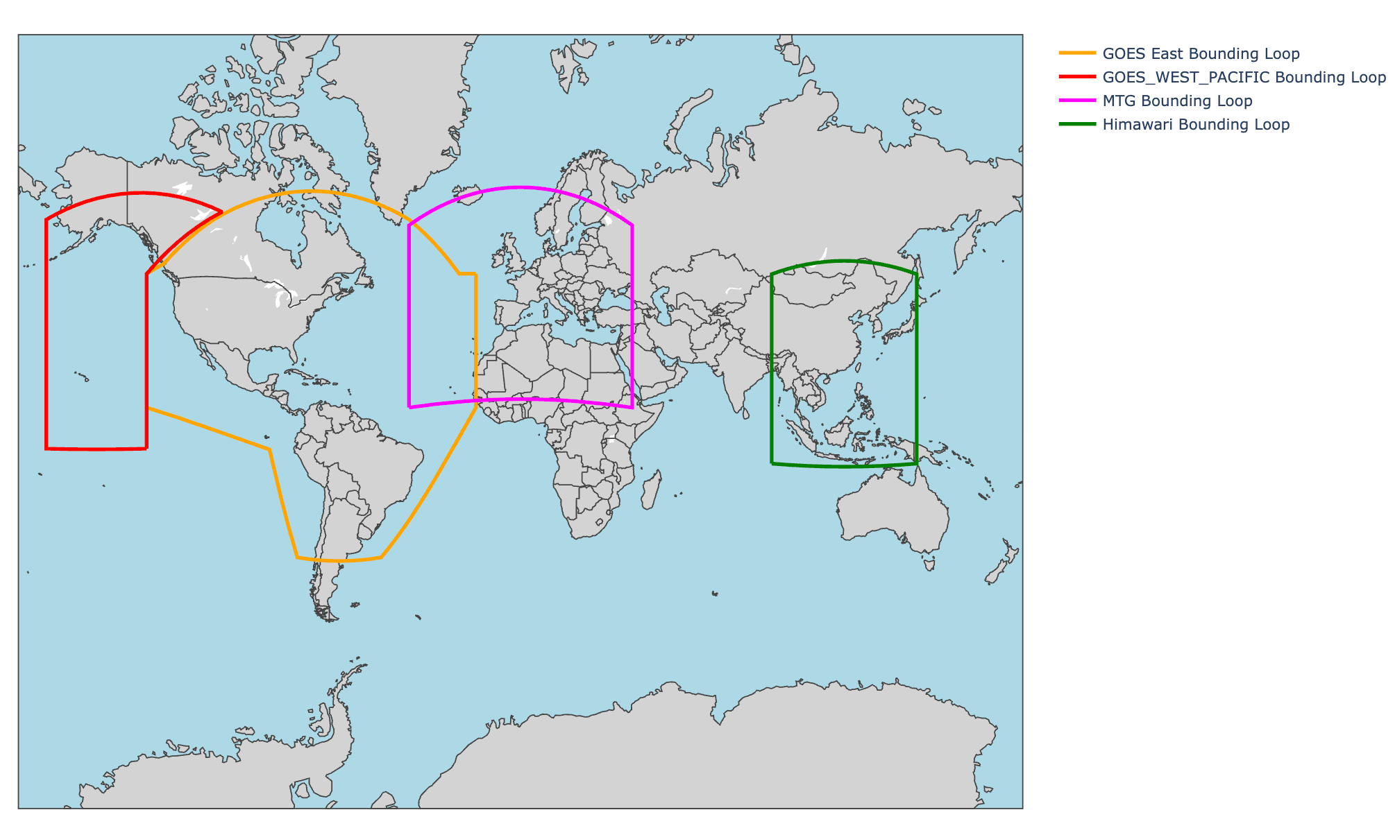
Among the available satellite data outputs, GOES East- and Himawari-based attributions have production-level quality, while MTG-based attributions are still in the Beta phase and actively undergoing quality improvements.
| Enums | |
|---|---|
DATA_SOURCE_UNSPECIFIED |
Unspecified data source. |
GOES_EAST_FULL_DISK |
Data from GOES-East full disk scans. |
GOES_WEST_FULL_DISK |
Data from GOES-West full disk scans. |
MTG_000_FULL_DISK |
Data from MTG-000 full disk scans. |
HIMAWARI_FULL_DISK |
Data from Himawari full disk scans. |
Contrails API satellite imagery is based on:
- NOAA GOES data 2019–2026
- EUMETSAT Meteosat FCI data 2024–2026, and
- JAMSTEC DIAS (Himawari data) 2025–2026
WaypointAttribution
Represents contrail attributes for a specific waypoint in a flight segment.
| JSON representation |
|---|
{
"time": string,
"contrailAttributes": {
object ( |
| Fields | |
|---|---|
time |
The time at the waypoint in UTC epoch seconds. |
contrailAttributes |
The contrail attributes mapped at this specific waypoint. |
AttributionMethod
Defines the specific procedure or methodology used to make the attribution.
| Enums | |
|---|---|
ATTRIBUTION_METHOD_OBSERVATION |
Attribution derived strictly by matching against satellite contrail detections. |
ATTRIBUTION_METHOD_COCIP |
Attributions relying strictly on physics-driven CoCiP modeling. |
ATTRIBUTION_METHOD_OBSERVATION_ENHANCED_COCIP |
Hybrid attribution combining CoCiP model forecasts adjusted by satellite detections.
|
ATTRIBUTION_METHOD_UNSPECIFIED |
Unspecified method. |
Notes
Each DataSource uses different bounds for processing observational-based
views:
License
The data exposed by the ContrailWatch Attributions API is licensed under CC BY-NC 4.0.