
Page Summary
-
The Universal Pollen Index (UPI) provides a globally unified scale for comparing pollen levels, aiding in assessing pollen exposure risk.
-
The UPI utilizes a six-category system (None, Very Low, Low, Moderate, High, Very High) to represent pollen concentration and potential allergy symptom severity.
-
Heatmap tiles visually display the UPI globally for three plant types: Tree, Grass, and Weed, allowing for easy comparison across locations.
-
Supported plant types in the Pollen API include a variety of trees, grasses, and weeds, although availability may vary based on data source and location.
What is the Universal Pollen Index (UPI)?
The Universal Pollen Index (UPI) is designed to offer a globally unified scale for comparing pollen levels across different areas. The index helps assess the risk of pollen exposure based on various factors for people allergic or sensitive to pollen. Based on a multilayer model, it is a representation of pollen level data that considers the concentration per plant model, many different local pollen indices (LPI) used worldwide, and the allergenicity of different plant pollen types to predict the number of pollen grains per cubic meter (grains/m3) per day.
The heatmapTiles endpoint returns heatmap tiles that can be overlaid
on a basemap. Heatmap tiles display the UPI across the globe for a given plant
type (TREE, GRASS, or WEED).
The index consists of six categories:
| Value | Color | Description |
|---|---|---|
| 0 |  |
None |
| 1 | |
Very Low |
| 2 | |
Low |
| 3 | |
Moderate |
| 4 | |
High |
| 5 | |
Very High |
Each category is based on specific concentration levels of pollen in a particular area and their effect on the severity of allergic symptoms that are usually experienced, providing a comprehensive representation of pollen levels. By integrating the UPI, users can compare and assess pollen conditions in various locations.
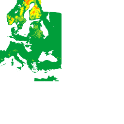
For example, the following heatmap tile shows TREE pollen levels ranging from
Very Low to Very High:
Supported plants
The Pollen API supports 3 different types of plants: Grass, Weed, and Tree. Because a plant's availability is subject to actual data source measurements and reports, Pollen API plant data may vary across locations.
The following list shows supported plant codes and their metadata:
| Plant Code | Display Name | Type |
|---|---|---|
ALDER |
Alder | Tree |
ASH |
Ash | Tree |
BIRCH |
Birch | Tree |
COTTONWOOD |
Cottonwood | Tree |
ELM |
Elm | Tree |
MAPLE |
Maple | Tree |
OLIVE |
Olive | Tree |
JUNIPER |
Juniper | Tree |
OAK |
Oak | Tree |
PINE |
Pine | Tree |
CYPRESS_PINE |
Cypress pine | Tree |
HAZEL |
Hazel | Tree |
GRAMINALES |
Grasses | Grass |
JAPANESE_CEDAR |
Japanese cedar | Tree |
JAPANESE_CYPRESS |
Japanese cypress | Tree |
RAGWEED |
Ragweed | Weed |
MUGWORT |
Mugwort | Weed |