Konum Seçimi'ni (Beta) kullanarak biniş noktaları arama
Koleksiyonlar ile düzeninizi koruyun
İçeriği tercihlerinize göre kaydedin ve kategorilere ayırın.
        const MAPS_API_KEY = '';  // Put your API Key for Maps SDK here
const LS_API_KEY = '';    // Put your API Key for Location Selection APIs here
const MAPS_URL = `https://maps.googleapis.com/maps/api/js?key=${
    MAPS_API_KEY}&libraries=places,geometry&callback=initMap`;
const LS_BASE_URL = 'https://locationselection.googleapis.com/v1beta';
const API_URL_PUPS_FOR_PLACE =
    `${LS_BASE_URL}:findPickupPointsForPlace?key=${LS_API_KEY}`;
const API_URL_PUPS_FOR_LOCATION =
    `${LS_BASE_URL}:findPickupPointsForLocation?key=${LS_API_KEY}`;
const API_URL_NEARBY_PLACES =
    `${LS_BASE_URL}:findNearbyPlaces?key=${LS_API_KEY}`;
const FORM_ID_PUPS_FOR_LOCATION = 'form-pups-for-location';
const FORM_ID_PUPS_FOR_PLACE = 'form-pups-for-place';
const FORM_ID_NEARBY_PLACES = 'form-nearby-places';
const FORM_TO_API_URL_MAP = {
  [FORM_ID_PUPS_FOR_LOCATION]: API_URL_PUPS_FOR_LOCATION,
  [FORM_ID_PUPS_FOR_PLACE]: API_URL_PUPS_FOR_PLACE,
  [FORM_ID_NEARBY_PLACES]: API_URL_NEARBY_PLACES,
};

const RED_PIN = 'http://maps.google.com/mapfiles/ms/icons/red-dot.png';
const GREEN_PIN = 'http://maps.google.com/mapfiles/ms/icons/green-dot.png';
const BLUE_PIN = 'http://maps.google.com/mapfiles/ms/icons/blue-dot.png';

const DEFAULT_ZOOM_LEVEL = 18;
// codepoint from https://fonts.google.com/icons
const SEARCH_LOCATION_MARKER = '\ue7f2';
const GOOGLEPLEX = {
  lat: 37.422001,
  lng: -122.084061
};
let map;
let polyLines = [];
let polygons = [];
let mapMarkers = [];
let entranceMarkers = [];

function loadMap() {
  const script = document.createElement('script');
  script.src = MAPS_URL;
  document.body.appendChild(script);
}

function initMap() {
  map = new google.maps.Map(
      document.getElementById('map'),
      {center: GOOGLEPLEX, zoom: DEFAULT_ZOOM_LEVEL});
}

function setupForm() {
  const form = document.getElementsByTagName('form')[0];
  form.addEventListener('submit', onFormSubmit);
}

function onFormSubmit(evt) {
  evt.preventDefault();
  evt.stopPropagation();
  const formData = new FormData(evt.target);
  fetchAPIResults(formData);
}

function transformFormData(fd) {
  let transformedFd = {
    localizationPreferences: {},
  };
  const formId = document.getElementsByTagName('form')[0].id;
  if (formId === FORM_ID_PUPS_FOR_LOCATION ||
      formId === FORM_ID_PUPS_FOR_PLACE) {
    transformedFd = {localizationPreferences: {}, travelModes: []};
  }
  const addSearchLocation = () => {
    if (transformedFd.searchLocation == null) {
      transformedFd.searchLocation = {};
    }
  };
  const addDestination = () => {
    if (transformedFd.destination == null) {
      transformedFd.destination = {};
    }
  };
  fd.forEach((value, key) => {
    switch (key) {
      case 'travelModes':
        transformedFd.travelModes.push(value);
        break;
      case 'languageCode':
        transformedFd.localizationPreferences[key] = value;
        break;
      case 'regionCode':
        transformedFd.localizationPreferences[key] = value;
        break;
      case 'searchLocation-latitude':
        if (value) {
          addSearchLocation();
          transformedFd.searchLocation['latitude'] = value;
        }
        break;
      case 'searchLocation-longitude':
        if (value) {
          addSearchLocation();
          transformedFd.searchLocation['longitude'] = value;
        }
        break;
      case 'destination-latitude':
        if (value) {
          addDestination();
          transformedFd.destination['latitude'] = value;
        }
        break;
      case 'destination-longitude':
        if (value) {
          addDestination();
          transformedFd.destination['longitude'] = value;
        }
        break;
      default:
        transformedFd[key] = value;
        break;
    }
  });
  const json = JSON.stringify(transformedFd, undefined, 2);
  return json;
}

async function fetchAPIResults(fd) {
  const formId = document.getElementsByTagName('form')[0].id;
  const url = FORM_TO_API_URL_MAP[formId];
  const transformedFd = transformFormData(fd);
  const response = await fetch(url, {method: 'POST', body: transformedFd});

  const result = await response.json();
  // Display JSON
  displayAPIResults(result);
  // Update map
  let searchLocation = {};
  if (JSON.parse(transformedFd).searchLocation) {
    searchLocation = {
      lat: Number(JSON.parse(transformedFd).searchLocation.latitude),
      lng: Number(JSON.parse(transformedFd).searchLocation.longitude),
    };
  }
  switch (formId) {
    case FORM_ID_PUPS_FOR_PLACE:
      markPickupPointsForPlace(result);
      break;
    case FORM_ID_PUPS_FOR_LOCATION:
      markPickupPointsForLocation(result, searchLocation);
      break;
    case FORM_ID_NEARBY_PLACES:
      markNearbyPlaces(result, searchLocation);
      break;
    default:
      break;
  }
}

function displayAPIResults(data) {
  const output = document.getElementById('output');
  output.textContent = JSON.stringify(data, undefined, 2);
}

function markNearbyPlaces(data, searchLocation) {
  if (data.error) {
    resetMap();
    return;
  }
  const places = [];
  for (const placeResult of data.placeResults) {
    places.push(placeResult.place);
  }

  resetMap(searchLocation);
  markPlaces(places, searchLocation);
  for (const place of places) {
    markEntrances(place.associatedCompounds, place);
  }
  markSearchLocation(searchLocation, '');
  for (const place of places) {
    mapPolygons(place.associatedCompounds);
  }
}

function markPickupPointsForPlace(data) {
  if (data.error) {
    resetMap();
    return;
  }
  const place = data.placeResult.place;
  const pickupPoints = data.pickupPointResults;
  const searchLocation = {
    lat: place.geometry.location.latitude,
    lng: place.geometry.location.longitude
  };
  resetMap(searchLocation);
  markPickupPoints(place, pickupPoints, searchLocation);
  markEntrances(place.associatedCompounds, place);
  markSearchLocation(searchLocation, place.displayName);
  createPolyLinesOneToMany(searchLocation, pickupPoints);
  mapPolygons(place.associatedCompounds);
}

function markPickupPointsForLocation(data, searchLocation) {
  if (data.error) {
    resetMap();
    return;
  }

  const placeIdToPlace = {};
  // A dict, and the key is placeId(str)s and the value is a list of pups.
  const placePickupPoints = {};
  data.placeResults.forEach(result => {
    placeIdToPlace[result.place.placeId] = result.place;
    placePickupPoints[result.place.placeId] = [];
  });
  data.placePickupPointResults.forEach(result => {
    placePickupPoints[result.associatedPlaceId].push(result.pickupPointResult);
  })
  resetMap(searchLocation);
  for (const placeId in placePickupPoints) {
    const place = placeIdToPlace[placeId];
    const pups = placePickupPoints[placeId];
    markEntrances(place.associatedCompounds, place);
    markPickupPoints(place, pups, searchLocation);
    createPolyLinesOneToMany(searchLocation, pups);
    mapPolygons(place.associatedCompounds);
  }
  // update the marker rank to global order
  for (let i = 0; i < mapMarkers.length; i++) {
    mapMarkers[i].label = String(i);
  }
  markSearchLocation(searchLocation, '');
}

function markPlaces(places, searchLocation) {
  for (const place of places) {
    const placeLocation = place.geometry.location;
    const infoWindow =
        new google.maps.InfoWindow({content: createInfoWindow(place, null)});
    const marker = new google.maps.Marker({
      position: toLatLngLiteral(placeLocation),
      animation: google.maps.Animation.DROP,
      map: map,
    });
    marker.addListener('click', () => {
      infoWindow.open(map, marker);
    });
    map.addListener('click', () => {
      infoWindow.close();
    });
    mapMarkers.push(marker);
  }
}

function markEntrances(compounds, place) {
  if (!compounds) {
    return;
  }
  for (const compound of compounds) {
    if (!compound.entrances) {
      continue;
    }
    for (const entrance of compound.entrances) {
      const entranceMarker = new google.maps.Marker({
        position: toLatLngLiteral(entrance.location),
        icon: {
          url: BLUE_PIN,
        },
        animation: google.maps.Animation.DROP,
        map: map,
      });
      const infoWindow =
          new google.maps.InfoWindow({content: createInfoWindow(place, null)});
      entranceMarker.addListener('click', () => {
        infoWindow.open(map, entranceMarker);
      });
      map.addListener('click', () => {
        infoWindow.close();
      });
      entranceMarkers.push(entranceMarker);
    }
  }
}

function mapPolygons(many) {
  if (!many) {
    return;
  }
  for (const toPoint of many) {
    const data = toPoint.geometry.displayBoundary;
    if (data == null || data.coordinates == null) {
      continue;
    }
    const value = data.coordinates;
    const polyArray = JSON.parse(JSON.stringify(value))[0];
    const usedColors = [];
    const finalLatLngs = [];
    let color = '';
    for (let i = 0; i < polyArray.length; ++i) {
      if (polyArray[i] != null && polyArray[i].length > 0) {
        color = getColor(usedColors);
        usedColors.push(color);
        if (isArrLatLng(polyArray[i])) {
          finalLatLngs.push({lat: polyArray[i][1], lng: polyArray[i][0]});
        }
      }
    }
    const poly = new google.maps.Polygon({
      strokeColor: color,
      strokeOpacity: 0.2,
      strokeWeight: 5,
      fillColor: color,
      fillOpacity: 0.1,
      paths: finalLatLngs,
      map: map,
    });
    polygons.push(poly);
  }
}

function getColor(usedColors) {
  let color = generateStrokeColor();
  while (usedColors.includes(color)) {
    color = generateStrokeColor();
  }
  return color;
}

function generateStrokeColor() {
  return Math.floor(Math.random() * 16777215).toString(16);
}

function isArrLatLng(currArr) {
  if (!currArr || currArr.length !== 2) {
    return false;
  }
  return ((typeof currArr[0]) === 'number') &&
      ((typeof currArr[1]) === 'number');
}

function toLatLngLiteral(latlng) {
  return {lat: latlng.latitude, lng: latlng.longitude};
}

function pickupHasRestrictions(pickupPointData) {
  let hasRestrictions = false;
  const travelDetails = pickupPointData.travelDetails;
  for (let i = 0; i < travelDetails.length; i++) {
    if (travelDetails[i].trafficRestriction !== 'NO_RESTRICTION') {
      hasRestrictions = true;
    }
  }
  return hasRestrictions;
}

function markPickupPoints(place, pickupPoints, searchLocation) {
  for (let i = 0; i < pickupPoints.length; i++) {
    const pickupPointData = pickupPoints[i];
    const pickupPoint = pickupPoints[i].pickupPoint;
    const pupIcon =
        pickupHasRestrictions(pickupPointData) ? RED_PIN : GREEN_PIN;
    const contentString = createInfoWindow(place, pickupPoint);
    const pupInfoWindow = new google.maps.InfoWindow({content: contentString});
    const marker = new google.maps.Marker({
      position: toLatLngLiteral(pickupPoint.location),
      label: {
        text: String(i),
        fontWeight: 'bold',
        fontSize: '20px',
        color: '#000'
      },
      animation: google.maps.Animation.DROP,
      map,
      icon: {
        url: pupIcon,
        anchor: new google.maps.Point(14, 43),
        labelOrigin: new google.maps.Point(-5, 5)
      },
    });
    marker.addListener('click', () => {
      pupInfoWindow.open(map, marker);
    });
    map.addListener('click', () => {
      pupInfoWindow.close();
    });
    mapMarkers.push(marker);
  }
}

function createInfoWindow(place, pickupPoint) {
  let result = [];
  const addResult = (value, key, map) =>
      result.push(`<p><span class="info-label">${key}:</span> ${value}</p>`);
  const formatAddress = (address) => address.lines.join(',');
  const placeFieldMap = new Map();
  if (place !== null) {
    placeFieldMap.set('Place', '');
    placeFieldMap.set('Name', place.displayName);
    placeFieldMap.set('Place ID', place.placeId);
    placeFieldMap.set('Address', formatAddress(place.address.formattedAddress));
  }
  const pickupPointFieldMap = new Map();
  if (pickupPoint !== null) {
    pickupPointFieldMap.set('Pickup point', '');
    pickupPointFieldMap.set('Name', pickupPoint.displayName);
  }
  placeFieldMap.forEach(addResult);
  result.push('<hr/>');
  pickupPointFieldMap.forEach(addResult);
  return result.join('');
}

function markSearchLocation(location, label) {
  const infoWindow =
      new google.maps.InfoWindow({content: `<p><b>Name: </b>${label}</p>`});
  const marker = new google.maps.Marker({
    position: location,
    map,
    label: {
      text: SEARCH_LOCATION_MARKER,
      fontFamily: 'Material Icons',
      color: '#ffffff',
      fontSize: '18px',
      fontWeight: 'bold',
    },
  });
  marker.addListener('click', () => {
    infoWindow.open(map, marker);
  });
  map.addListener('click', () => {
    infoWindow.close();
  });
  mapMarkers.push(marker);
}

function createPolyLinesOneToMany(one, many) {
  const lineSymbol = {
    path: google.maps.SymbolPath.FORWARD_CLOSED_ARROW,
  };
  for (const toPoint of many) {
    const line = new google.maps.Polyline({
      path: [one, toLatLngLiteral(toPoint.pickupPoint.location)],
      icons: [
        {
          icon: lineSymbol,
          offset: '100%',
        },
      ],
      map: map,
    });
    polyLines.push(line);
  }
}

/******* Reset the map ******/
function deleteMarkers() {
  for (const mapMarker of mapMarkers) {
    mapMarker.setMap(null);
  }
  mapMarkers = [];
}

function deletePolyLines() {
  for (const polyLine of polyLines) {
    polyLine.setMap(null);
  }
  polyLines = [];
}

function deleteEntranceMarkers() {
  for (const entranceMarker of entranceMarkers) {
    entranceMarker.setMap(null);
  }
  entranceMarkers = [];
}

function clearPolygons() {
  for (let i = 0; i < polygons.length; i++) {
    polygons[i].setMap(null);
  }
  polygons = [];
}

function resetMap(searchLocation) {
  if (searchLocation) {
    map.setCenter(searchLocation);
  } else {
    map.setCenter(GOOGLEPLEX);
  }
  map.setZoom(DEFAULT_ZOOM_LEVEL);
  deleteMarkers();
  deletePolyLines();
  deleteEntranceMarkers();
  clearPolygons();
}
// Initiate map & set form event handlers
loadMap();
setupForm();
Araç alma noktalarını aramak için Location Selection API'yi kullanmadan önce istemci kitaplığıyla entegrasyon talimatlarını uygulayın.
Konum Seçimi hizmeti, teslim alma ve bırakma yeri seçimi için üç API sağlar: FindNearbyPlaces, FindPickupPointsForPlace ve FindPickupPointsForLocation.
Aramanın veya cihaz konumunun yakınındaki yerleri almak için FindNearbyPlaces simgesini kullanın. Yerler, konuma yakınlıklarına ve araç paylaşımı için öne çıkmalarına göre sıralanır. FindNearbyPlaces, kullanıcının en iyi seçimi yapmasına olanak tanımak için görüntülenebilecek yerlerin listesini döndürür. Bir yer seçildikten sonra, FindPickupPointsForPlace simgesini kullanarak seçilen yerin teslim alma noktalarını getirebilirsiniz.
Aynı RPC çağrısında arama veya cihaz konumunun yakınındaki yerleri ve bunlarla ilişkili teslim alma noktalarını almak için FindPickupPointsForLocation değerini kullanın.
Her teslim noktası bir yerle ilişkilendirilir. Araç alma noktaları, konuma olan yakınlıklarına ve araç paylaşımı için öne çıkan özelliklerine göre sıralanır. Birden fazla yerin teslim noktalarının birlikte sıralandığını unutmayın. FindPickupPointsForLocation, FindNearbyPlaces ve FindPickupPointsForPlace özelliklerini birleştirir. Örneğin, istek konumunun P1, P2 ve P3 yerlerinin yakınında olduğunu varsayalım. En iyi teslim noktası T1, P2 yeri ile ilişkilendirilmişse ve bir sonraki en iyi teslim noktası P1 yeri ile ilişkilendirilmişse sonuçlar [T1:P2, T2:P1, ...] şeklinde sıralanır.
Teslim alma noktaları seçilmeden önce kullanıcıya yerleri göstermeyi veya bir raptiye sürükleyerek yakındaki yerleri göstermeyi tercih ediyorsanız aşağıdaki RPC çağrısını kullanın:
FindNearbyPlacesRequest find_nearby_places_request =
  FindNearbyPlacesRequest.newBuilder()
      .setLocalizationPreferences(LocalizationPreferences.newBuilder()
        // Language used for localizing text such as name or address.
        .setLanguageCode("en")
        .setRegionCode("US")
        .build())
      // Rider's location or location of dragged pin.
      .setSearchLocation(LatLng.newBuilder().setLatitude(37.365647).setLongitude(-121.925356))
      // Number of places requested.
      .setMaxResults(3)
      .build();

FindNearbyPlacesResponse findNearbyPlacesResponse =
  locationSelectionBetaClient.findNearbyPlaces(find_nearby_places_request);
RPC çağrısı, giriş ölçütlerini karşılayan ve yakınlık ile belirginlik kombinasyonuna göre sıralanmış bir yer yanıtları listesi döndürür. Kullanıcının bir yer seçmesine izin verebilir veya ilk sonucu kullanıp teslim alma noktasını seçmeye devam edebilirsiniz. Her yer yanıtının, teslim alma noktalarını almak için FindPickupPointsForPlaceRequest içinde kullanılabilecek benzersiz bir place_id değeri vardır. Daha fazla bilgi için Yer kimliğine göre arama başlıklı makaleyi inceleyin.
FindPickupPointsForLocationRequest FindPickupPointsForLocationRequest =
    FindPickupPointsForLocationRequest.newBuilder()
        // Language used for localizing text such as name and address.
        .setLocalizationPreferences(LocalizationPreferences.newBuilder().setRegionCode("US").setLanguageCode("en"))
        // The search location of the rider or the dropped pin.
        .setSearchLocation(LatLng.newBuilder().setLatitude(-23.482049).setLongitude(-46.602135))
        // The max results returned.
        .setMaxResults(5)
        // List of travel modes. At least one of the travel modes must be supported by the pickup points.
        .addTravelModes(TravelMode.DRIVING)
        // Specifies the sorting order of matching pickup points.
        .setOrderBy(PickupPointOrder.DISTANCE_FROM_SEARCH_LOCATION)
        .build();

FindPickupPointsForLocationResponse FindPickupPointsForLocationResponse =
    locationSelectionService.FindPickupPointsForLocation(
        RpcClientContext.create(), FindPickupPointsForLocationRequest);
RPC çağrısı, giriş ölçütlerini karşılayan teslim alma noktalarının, yakınlık ve belirginlik kombinasyonuna göre sıralanmış bir listesini döndürür. Bu RPC çağrısı, FindNearbyPlaces ve FindPickupPointsForPlaceRequest'u birleştirir ve diğer iki çağrıyı birleştirmek yerine kullanılabilir.
Yer kimliğine göre arama
FindNearbyPlaces kullanarak veya Places API Otomatik Tamamlama hizmetini kullanarak place_id elde edebilirsiniz. Ardından, belirtilen yer için en uygun teslim alma noktalarını sağlamak üzere aşağıdaki RPC çağrısını kullanın:
FindPickupPointsForPlaceRequest findPickupPointsForPlaceRequest =
    FindPickupPointsForPlaceRequest.newBuilder()
        // Language used for localizing text such as name and address.
        .setLocalizationPreferences(LocalizationPreferences.newBuilder().setRegionCode("US").setLanguageCode("en"))
        // Place ID of the place for which pickup points are being fetched;
        // for example, Hilton Hotel, Downtown San Jose.
        .setPlaceId("ChIJwTUa-q_Mj4ARff4yludGH-M")
        // List of travel modes. At least one of the travel modes must be supported by the pickup points.
        .addTravelModes(TravelMode.DRIVING)
        // Rider's location or location of dragged pin.
        // It is recommended to use the same location that was used in `FindNearbyPlaces` for better quality.
        .setSearchLocation(LatLng.newBuilder().setLatitude(37.329472).setLongitude(-121.890449))
        .setOrderBy(PickupPointOrder.DISTANCE_FROM_SEARCH_LOCATION)
        .setMaxResults(5)
         .build();

FindPickupPointsForPlaceResponse findPickupPointsForPlaceResponse =
    locationSelectionBetaClient.findPickupPointsForPlace(findPickupPointsForPlaceRequest);
FindPickupPointsForPlace, bir yolcunun alınabileceği noktaların enlem ve boylamını içeren PickupPointResponses değerini döndürür.
Birden fazla seyahat için alma noktalarını optimize etme
Paylaşılan veya art arda yapılan yolculuklar için FindPickupPointsForPlace, DRIVING_ETA_FROM_PICKUP_POINT_TO_DESTINATION'ye göre teslim alma noktalarının sıralanması özelliğini destekler. Bu sayede, bir sonraki seyahat için sürücünün mevcut seyahat rotasıyla optimize edilmiş bir teslim alma noktası döndürebilirsiniz.
Örnek
FindPickupPointsForPlaceRequest findPickupPointsForPlaceRequest =
    FindPickupPointsForPlaceRequest.newBuilder()
        // Language used for localizing text such as name and address.
        .setLocalizationPreferences(LocalizationPreferences.newBuilder().setRegionCode("US").setLanguageCode("en"))
        // Place ID of the place for which pickup points are being fetched;
        // for example, Hilton Hotel, Downtown San Jose.
        .setPlaceId("ChIJwTUa-q_Mj4ARff4yludGH-M")
        // List of travel modes. At least one of the travel modes must be supported by the pickup points.
        .addTravelModes(TravelMode.DRIVING)
        // Second rider's location or location of dragged pin.
        .setSearchLocation(LatLng.newBuilder().setLatitude(37.329472).setLongitude(-121.890449))
        // Location of the driver's next drop off after picking up the second
        // rider. Note, it is not necessarily the second rider's destination.
        .setDestination(LatLng.newBuilder().setLatitude(37.329472).setLongitude(-121.890449))
        .setOrderBy(PickupPointOrder.DRIVING_ETA_FROM_PICKUP_POINT_TO_DESTINATION)
        .setComputeDrivingEta(true)
        .setMaxResults(5)
        .build();

FindPickupPointsForPlaceResponse findPickupPointsForPlaceResponse =
    locationSelectionBetaClient.findPickupPointsForPlace(findPickupPointsForPlaceRequest);
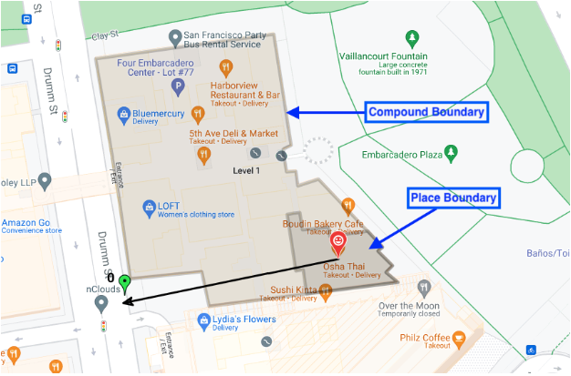
Bina dış çizgilerini, girişlerini ve çıkışlarını gösterme
Yer proto yanıt mesajında associatedCompounds alanı, yerle ilişkili bileşikleri tanımlar. Karma ileti üç tür bilgi içerir:
Bileşik türü: Dört seçenekten biri
compoundBuilding: AVM veya süpermarket gibi tek bir bağımsız bina.
compoundSection: Daha büyük bir tesis içindeki bir tesis (ör. alışveriş merkezindeki tek bir mağaza).
compoundGrounds: Bir compoundBuilding ile ilişkili her şey (ör. bir alışveriş merkezi, otopark ve bu otoparktaki diğer binalar).
unrecognized: Varsayılan değer
Geometri: displayBoundary alanındaki bir GeoJSON yapısında depolanan, ana hatlarıyla belirtilen poligonun koordinatları. Bu koordinatlar, bölümün, binanın veya arazinin ana hatlarını oluşturmak için kullanılır.
Girişler: Bulunan tüm giriş ve çıkışların enlem ve boylam koordinatları.
Konum Seçimi, arama konumuyla ilişkili tüm bileşik türlerini döndürür. Arama konumu bir alışveriş merkezindeki belirli bir mağazadaysa Konum Seçimi aşağıdakileri döndürür:
* Belirli mağaza, girişleri ve çıkışları ve mağazanın ana hatları
* Kompleksin binası (alışveriş merkezi), girişleri ve çıkışları ve alışveriş merkezinin ana hatları
* Kompleksin arazisi (alışveriş merkezi + otopark), girişleri ve çıkışları ve arazinin tamamının ana hatları
Bu resimde, döndürülen üç bileşik türü de gösterilmektedir.
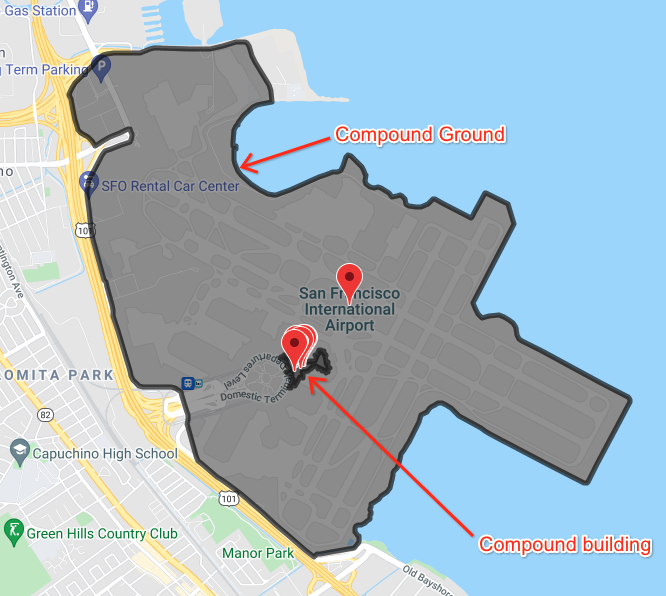
Bu resimde, havalimanı içindeki bir binanın yanı sıra havalimanının ve ilgili tüm alanların sınırları gösterilerek havalimanının içinde yer alan çeşitli konumlar gösterilmektedir.
[[["Anlaması kolay","easyToUnderstand","thumb-up"],["Sorunumu çözdü","solvedMyProblem","thumb-up"],["Diğer","otherUp","thumb-up"]],[["İhtiyacım olan bilgiler yok","missingTheInformationINeed","thumb-down"],["Çok karmaşık / çok fazla adım var","tooComplicatedTooManySteps","thumb-down"],["Güncel değil","outOfDate","thumb-down"],["Çeviri sorunu","translationIssue","thumb-down"],["Örnek veya kod sorunu","samplesCodeIssue","thumb-down"],["Diğer","otherDown","thumb-down"]],["Son güncelleme tarihi: 2026-05-31 UTC."],[],["This application uses Google Maps and Location Selection APIs to display location data. Users input details like `placeId`, language/region codes, and coordinates to find pickup points. The form data is transformed into JSON and sent to the APIs. Results are displayed both as raw JSON and visually on a map. The map shows markers for places, pickup points, entrances, and polylines connecting locations and polygons for compound boundaries. Users can interact with markers to view info windows. It uses javascript functions for each action in order to process and display the results.\n"]]