חיפוש נקודות איסוף באמצעות 'בחירת מיקום' (בטא)

        <html lang="en">
  <head>
    <meta charset="utf-8">
    <title>Location Selection Demo</title>
    <meta name="viewport" content="width=device-width, initial-scale=1">
    <link href="https://fonts.googleapis.com/icon?family=Material+Icons" rel="stylesheet">
  </head>
  <body>
  <h1>Location Selection Demo - FindPickupPointsForPlace</h1>
  <div class="container">
    <section class="form-container">
      <form id="form-pups-for-place" name="location-selection">
        <label class="form-label" for="placeId">Place ID</label>
        <input type="text" id="placeId" name="placeId" value="ChIJwTUa-q_Mj4ARff4yludGH-M" />

        <label class="form-label" for="languageCode">Language Code</label>
        <input type="text" id="languageCode" name="languageCode" value="en-US" />

        <label class="form-label" for="regionCode">Region Code</label>
        <input type="text" id="regionCode" name="regionCode" value="US" />

        <label class="form-label" for="searchLocation-latitude">Search Location - Latitude</label>
        <input type="text" id="searchLocation-latitude" name="searchLocation-latitude" value="37.329472" />

        <label class="form-label" for="searchLocation-longitude">Search Location - Longitude</label>
        <input type="text" id="searchLocation-longitude" name="searchLocation-longitude" value="-121.890449" />

        <label class="form-label" for="orderBy">Order By</label>
        <select id="orderBy" name="orderBy">
          <option value="DISTANCE_FROM_SEARCH_LOCATION" selected>DISTANCE_FROM_SEARCH_LOCATION</option>
          <option value="WALKING_ETA_FROM_SEARCH_LOCATION">WALKING_ETA_FROM_SEARCH_LOCATION</option>
          <option value="DRIVING_ETA_FROM_PICKUP_POINT_TO_DESTINATION">DRIVING_ETA_FROM_PICKUP_POINT_TO_DESTINATION</option>
        </select>

        <label class="form-label" for="destination-latitude">Destination - Latitude</label>
        <input type="text" id="destination-latitude" name="destination-latitude" value="" />

        <label class="form-label" for="destination-longitude">Destination - Longitude</label>
        <input type="text" id="destination-longitude" name="destination-longitude" value="" />

        <label class="form-label" for="maxResults">Max Results</label>
        <input type="number" id="maxResults" name="maxResults" min="1" value="5" step="1" />

        <fieldset>
          <legend>Travel Modes</legend>
          <div>
            <input type="checkbox" id="walking" name="travelModes" value="WALKING" checked>
            <label for="walking" class="form-checkbox-label">WALKING</label>
          </div>
          <div>
            <input type="checkbox" id="driving" name="travelModes" value="DRIVING" checked>
            <label for="driving" class="form-checkbox-label">DRIVING</label>
          </div>
          <div>
            <input type="checkbox" id="twoWheeler" name="travelModes" value="TWO_WHEELER">
            <label for="twoWheeler" class="form-checkbox-label">TWO_WHEELER</label>
          </div>
        </fieldset>

        <label class="form-label" for="computeWalkingEta">Compute Walking ETA</label>
        <select id="computeWalkingEta" name="computeWalkingEta" class="boolean">
          <option value="true">true</option>
          <option value="false" selected>false</option>
        </select>

        <label class="form-label" for="computeDrivingEta">Compute Driving ETA</label>
        <select id="computeDrivingEta" name="computeDrivingEta" class="boolean">
          <option value="true">true</option>
          <option value="false" selected>false</option>
        </select>

        <input class="submit-button" type="submit" value="Call" />
      </form>
    </section>
    <section>
      <div id="map" class="map"></div>
    </section>
  </div>
  <section class="output-container">
    <h2>Response</h2>
    <pre id="output"></pre>
  </section>
  </body>
  </html>
    
        body {
    font-family: 'Google Sans';
}

.container {
    display: grid;
    grid-template-columns: 30% 1fr;
    grid-template-rows: 100%;
    grid-column-gap: 20px;
    grid-row-gap: 0px;
}

h1 {
    font-size: 24px;
    margin-top: 20px;
    margin-bottom: 20px;
    font-weight: bold;
}

h2 {
    font-size: 18px;
    font-weight: bold;
}

h1,
.form-container,
.output-container {
    margin-left: 20px;
}

.map,
.output-container {
    margin-right: 20px;
}

.form-container {
    border: 1px solid black;
    padding: 20px;
}

.map {
    border: 1px solid black;
    min-height: 800px;
}

.output-container {
    margin-top: 20px;
}

#output {
    border: 1px solid red;
    font-family: 'Google Sans';
    min-height: 150px;
}


label:not(.form-checkbox-label), legend {
    overflow-wrap: break-word;
    font-weight: bold;
}

input:not([type="checkbox"]), select, fieldset {
    font-family: 'Google Sans';
    width: 100%;
    padding: 5px 5px;
    margin: 0 0 20px 0;
    display: inline-block;
    border: 1px solid #ccc;
    border-radius: 8px;
    box-sizing: border-box;
}


input[type="submit"] {
    min-width: 150px;
    background-color: green; /* Blue */
    border: none;
    color: white;
    padding: 15px 15px;
    text-decoration: none;
    display: inline-block;
    font-size: 16px;
    border-radius: 20px;
    width: 50%;
}

input[type="submit"]:hover {
    background-color: darkseagreen;
}

input[type="submit"]:active {
    background-color: darkseagreen;
    box-shadow: 0 5px #666;
    transform: translateY(4px);
}

.info-label {
    font-weight: bold;
}

    
        const MAPS_API_KEY = '';  // Put your API Key for Maps SDK here
const LS_API_KEY = '';    // Put your API Key for Location Selection APIs here
const MAPS_URL = `https://maps.googleapis.com/maps/api/js?key=${
    MAPS_API_KEY}&libraries=places,geometry&callback=initMap`;
const LS_BASE_URL = 'https://locationselection.googleapis.com/v1beta';
const API_URL_PUPS_FOR_PLACE =
    `${LS_BASE_URL}:findPickupPointsForPlace?key=${LS_API_KEY}`;
const API_URL_PUPS_FOR_LOCATION =
    `${LS_BASE_URL}:findPickupPointsForLocation?key=${LS_API_KEY}`;
const API_URL_NEARBY_PLACES =
    `${LS_BASE_URL}:findNearbyPlaces?key=${LS_API_KEY}`;
const FORM_ID_PUPS_FOR_LOCATION = 'form-pups-for-location';
const FORM_ID_PUPS_FOR_PLACE = 'form-pups-for-place';
const FORM_ID_NEARBY_PLACES = 'form-nearby-places';
const FORM_TO_API_URL_MAP = {
  [FORM_ID_PUPS_FOR_LOCATION]: API_URL_PUPS_FOR_LOCATION,
  [FORM_ID_PUPS_FOR_PLACE]: API_URL_PUPS_FOR_PLACE,
  [FORM_ID_NEARBY_PLACES]: API_URL_NEARBY_PLACES,
};

const RED_PIN = 'http://maps.google.com/mapfiles/ms/icons/red-dot.png';
const GREEN_PIN = 'http://maps.google.com/mapfiles/ms/icons/green-dot.png';
const BLUE_PIN = 'http://maps.google.com/mapfiles/ms/icons/blue-dot.png';

const DEFAULT_ZOOM_LEVEL = 18;
// codepoint from https://fonts.google.com/icons
const SEARCH_LOCATION_MARKER = '\ue7f2';
const GOOGLEPLEX = {
  lat: 37.422001,
  lng: -122.084061
};
let map;
let polyLines = [];
let polygons = [];
let mapMarkers = [];
let entranceMarkers = [];

function loadMap() {
  const script = document.createElement('script');
  script.src = MAPS_URL;
  document.body.appendChild(script);
}

function initMap() {
  map = new google.maps.Map(
      document.getElementById('map'),
      {center: GOOGLEPLEX, zoom: DEFAULT_ZOOM_LEVEL});
}

function setupForm() {
  const form = document.getElementsByTagName('form')[0];
  form.addEventListener('submit', onFormSubmit);
}

function onFormSubmit(evt) {
  evt.preventDefault();
  evt.stopPropagation();
  const formData = new FormData(evt.target);
  fetchAPIResults(formData);
}

function transformFormData(fd) {
  let transformedFd = {
    localizationPreferences: {},
  };
  const formId = document.getElementsByTagName('form')[0].id;
  if (formId === FORM_ID_PUPS_FOR_LOCATION ||
      formId === FORM_ID_PUPS_FOR_PLACE) {
    transformedFd = {localizationPreferences: {}, travelModes: []};
  }
  const addSearchLocation = () => {
    if (transformedFd.searchLocation == null) {
      transformedFd.searchLocation = {};
    }
  };
  const addDestination = () => {
    if (transformedFd.destination == null) {
      transformedFd.destination = {};
    }
  };
  fd.forEach((value, key) => {
    switch (key) {
      case 'travelModes':
        transformedFd.travelModes.push(value);
        break;
      case 'languageCode':
        transformedFd.localizationPreferences[key] = value;
        break;
      case 'regionCode':
        transformedFd.localizationPreferences[key] = value;
        break;
      case 'searchLocation-latitude':
        if (value) {
          addSearchLocation();
          transformedFd.searchLocation['latitude'] = value;
        }
        break;
      case 'searchLocation-longitude':
        if (value) {
          addSearchLocation();
          transformedFd.searchLocation['longitude'] = value;
        }
        break;
      case 'destination-latitude':
        if (value) {
          addDestination();
          transformedFd.destination['latitude'] = value;
        }
        break;
      case 'destination-longitude':
        if (value) {
          addDestination();
          transformedFd.destination['longitude'] = value;
        }
        break;
      default:
        transformedFd[key] = value;
        break;
    }
  });
  const json = JSON.stringify(transformedFd, undefined, 2);
  return json;
}

async function fetchAPIResults(fd) {
  const formId = document.getElementsByTagName('form')[0].id;
  const url = FORM_TO_API_URL_MAP[formId];
  const transformedFd = transformFormData(fd);
  const response = await fetch(url, {method: 'POST', body: transformedFd});

  const result = await response.json();
  // Display JSON
  displayAPIResults(result);
  // Update map
  let searchLocation = {};
  if (JSON.parse(transformedFd).searchLocation) {
    searchLocation = {
      lat: Number(JSON.parse(transformedFd).searchLocation.latitude),
      lng: Number(JSON.parse(transformedFd).searchLocation.longitude),
    };
  }
  switch (formId) {
    case FORM_ID_PUPS_FOR_PLACE:
      markPickupPointsForPlace(result);
      break;
    case FORM_ID_PUPS_FOR_LOCATION:
      markPickupPointsForLocation(result, searchLocation);
      break;
    case FORM_ID_NEARBY_PLACES:
      markNearbyPlaces(result, searchLocation);
      break;
    default:
      break;
  }
}

function displayAPIResults(data) {
  const output = document.getElementById('output');
  output.textContent = JSON.stringify(data, undefined, 2);
}

function markNearbyPlaces(data, searchLocation) {
  if (data.error) {
    resetMap();
    return;
  }
  const places = [];
  for (const placeResult of data.placeResults) {
    places.push(placeResult.place);
  }

  resetMap(searchLocation);
  markPlaces(places, searchLocation);
  for (const place of places) {
    markEntrances(place.associatedCompounds, place);
  }
  markSearchLocation(searchLocation, '');
  for (const place of places) {
    mapPolygons(place.associatedCompounds);
  }
}

function markPickupPointsForPlace(data) {
  if (data.error) {
    resetMap();
    return;
  }
  const place = data.placeResult.place;
  const pickupPoints = data.pickupPointResults;
  const searchLocation = {
    lat: place.geometry.location.latitude,
    lng: place.geometry.location.longitude
  };
  resetMap(searchLocation);
  markPickupPoints(place, pickupPoints, searchLocation);
  markEntrances(place.associatedCompounds, place);
  markSearchLocation(searchLocation, place.displayName);
  createPolyLinesOneToMany(searchLocation, pickupPoints);
  mapPolygons(place.associatedCompounds);
}

function markPickupPointsForLocation(data, searchLocation) {
  if (data.error) {
    resetMap();
    return;
  }

  const placeIdToPlace = {};
  // A dict, and the key is placeId(str)s and the value is a list of pups.
  const placePickupPoints = {};
  data.placeResults.forEach(result => {
    placeIdToPlace[result.place.placeId] = result.place;
    placePickupPoints[result.place.placeId] = [];
  });
  data.placePickupPointResults.forEach(result => {
    placePickupPoints[result.associatedPlaceId].push(result.pickupPointResult);
  })
  resetMap(searchLocation);
  for (const placeId in placePickupPoints) {
    const place = placeIdToPlace[placeId];
    const pups = placePickupPoints[placeId];
    markEntrances(place.associatedCompounds, place);
    markPickupPoints(place, pups, searchLocation);
    createPolyLinesOneToMany(searchLocation, pups);
    mapPolygons(place.associatedCompounds);
  }
  // update the marker rank to global order
  for (let i = 0; i < mapMarkers.length; i++) {
    mapMarkers[i].label = String(i);
  }
  markSearchLocation(searchLocation, '');
}

function markPlaces(places, searchLocation) {
  for (const place of places) {
    const placeLocation = place.geometry.location;
    const infoWindow =
        new google.maps.InfoWindow({content: createInfoWindow(place, null)});
    const marker = new google.maps.Marker({
      position: toLatLngLiteral(placeLocation),
      animation: google.maps.Animation.DROP,
      map: map,
    });
    marker.addListener('click', () => {
      infoWindow.open(map, marker);
    });
    map.addListener('click', () => {
      infoWindow.close();
    });
    mapMarkers.push(marker);
  }
}

function markEntrances(compounds, place) {
  if (!compounds) {
    return;
  }
  for (const compound of compounds) {
    if (!compound.entrances) {
      continue;
    }
    for (const entrance of compound.entrances) {
      const entranceMarker = new google.maps.Marker({
        position: toLatLngLiteral(entrance.location),
        icon: {
          url: BLUE_PIN,
        },
        animation: google.maps.Animation.DROP,
        map: map,
      });
      const infoWindow =
          new google.maps.InfoWindow({content: createInfoWindow(place, null)});
      entranceMarker.addListener('click', () => {
        infoWindow.open(map, entranceMarker);
      });
      map.addListener('click', () => {
        infoWindow.close();
      });
      entranceMarkers.push(entranceMarker);
    }
  }
}

function mapPolygons(many) {
  if (!many) {
    return;
  }
  for (const toPoint of many) {
    const data = toPoint.geometry.displayBoundary;
    if (data == null || data.coordinates == null) {
      continue;
    }
    const value = data.coordinates;
    const polyArray = JSON.parse(JSON.stringify(value))[0];
    const usedColors = [];
    const finalLatLngs = [];
    let color = '';
    for (let i = 0; i < polyArray.length; ++i) {
      if (polyArray[i] != null && polyArray[i].length > 0) {
        color = getColor(usedColors);
        usedColors.push(color);
        if (isArrLatLng(polyArray[i])) {
          finalLatLngs.push({lat: polyArray[i][1], lng: polyArray[i][0]});
        }
      }
    }
    const poly = new google.maps.Polygon({
      strokeColor: color,
      strokeOpacity: 0.2,
      strokeWeight: 5,
      fillColor: color,
      fillOpacity: 0.1,
      paths: finalLatLngs,
      map: map,
    });
    polygons.push(poly);
  }
}

function getColor(usedColors) {
  let color = generateStrokeColor();
  while (usedColors.includes(color)) {
    color = generateStrokeColor();
  }
  return color;
}

function generateStrokeColor() {
  return Math.floor(Math.random() * 16777215).toString(16);
}

function isArrLatLng(currArr) {
  if (!currArr || currArr.length !== 2) {
    return false;
  }
  return ((typeof currArr[0]) === 'number') &&
      ((typeof currArr[1]) === 'number');
}

function toLatLngLiteral(latlng) {
  return {lat: latlng.latitude, lng: latlng.longitude};
}

function pickupHasRestrictions(pickupPointData) {
  let hasRestrictions = false;
  const travelDetails = pickupPointData.travelDetails;
  for (let i = 0; i < travelDetails.length; i++) {
    if (travelDetails[i].trafficRestriction !== 'NO_RESTRICTION') {
      hasRestrictions = true;
    }
  }
  return hasRestrictions;
}

function markPickupPoints(place, pickupPoints, searchLocation) {
  for (let i = 0; i < pickupPoints.length; i++) {
    const pickupPointData = pickupPoints[i];
    const pickupPoint = pickupPoints[i].pickupPoint;
    const pupIcon =
        pickupHasRestrictions(pickupPointData) ? RED_PIN : GREEN_PIN;
    const contentString = createInfoWindow(place, pickupPoint);
    const pupInfoWindow = new google.maps.InfoWindow({content: contentString});
    const marker = new google.maps.Marker({
      position: toLatLngLiteral(pickupPoint.location),
      label: {
        text: String(i),
        fontWeight: 'bold',
        fontSize: '20px',
        color: '#000'
      },
      animation: google.maps.Animation.DROP,
      map,
      icon: {
        url: pupIcon,
        anchor: new google.maps.Point(14, 43),
        labelOrigin: new google.maps.Point(-5, 5)
      },
    });
    marker.addListener('click', () => {
      pupInfoWindow.open(map, marker);
    });
    map.addListener('click', () => {
      pupInfoWindow.close();
    });
    mapMarkers.push(marker);
  }
}

function createInfoWindow(place, pickupPoint) {
  let result = [];
  const addResult = (value, key, map) =>
      result.push(`<p><span class="info-label">${key}:</span> ${value}</p>`);
  const formatAddress = (address) => address.lines.join(',');
  const placeFieldMap = new Map();
  if (place !== null) {
    placeFieldMap.set('Place', '');
    placeFieldMap.set('Name', place.displayName);
    placeFieldMap.set('Place ID', place.placeId);
    placeFieldMap.set('Address', formatAddress(place.address.formattedAddress));
  }
  const pickupPointFieldMap = new Map();
  if (pickupPoint !== null) {
    pickupPointFieldMap.set('Pickup point', '');
    pickupPointFieldMap.set('Name', pickupPoint.displayName);
  }
  placeFieldMap.forEach(addResult);
  result.push('<hr/>');
  pickupPointFieldMap.forEach(addResult);
  return result.join('');
}

function markSearchLocation(location, label) {
  const infoWindow =
      new google.maps.InfoWindow({content: `<p><b>Name: </b>${label}</p>`});
  const marker = new google.maps.Marker({
    position: location,
    map,
    label: {
      text: SEARCH_LOCATION_MARKER,
      fontFamily: 'Material Icons',
      color: '#ffffff',
      fontSize: '18px',
      fontWeight: 'bold',
    },
  });
  marker.addListener('click', () => {
    infoWindow.open(map, marker);
  });
  map.addListener('click', () => {
    infoWindow.close();
  });
  mapMarkers.push(marker);
}

function createPolyLinesOneToMany(one, many) {
  const lineSymbol = {
    path: google.maps.SymbolPath.FORWARD_CLOSED_ARROW,
  };
  for (const toPoint of many) {
    const line = new google.maps.Polyline({
      path: [one, toLatLngLiteral(toPoint.pickupPoint.location)],
      icons: [
        {
          icon: lineSymbol,
          offset: '100%',
        },
      ],
      map: map,
    });
    polyLines.push(line);
  }
}

/******* Reset the map ******/
function deleteMarkers() {
  for (const mapMarker of mapMarkers) {
    mapMarker.setMap(null);
  }
  mapMarkers = [];
}

function deletePolyLines() {
  for (const polyLine of polyLines) {
    polyLine.setMap(null);
  }
  polyLines = [];
}

function deleteEntranceMarkers() {
  for (const entranceMarker of entranceMarkers) {
    entranceMarker.setMap(null);
  }
  entranceMarkers = [];
}

function clearPolygons() {
  for (let i = 0; i < polygons.length; i++) {
    polygons[i].setMap(null);
  }
  polygons = [];
}

function resetMap(searchLocation) {
  if (searchLocation) {
    map.setCenter(searchLocation);
  } else {
    map.setCenter(GOOGLEPLEX);
  }
  map.setZoom(DEFAULT_ZOOM_LEVEL);
  deleteMarkers();
  deletePolyLines();
  deleteEntranceMarkers();
  clearPolygons();
}
// Initiate map & set form event handlers
loadMap();
setupForm();


        <html lang="en">
<head>
  <meta charset="utf-8">
  <title>Location Selection Demo</title>
  <meta name="viewport" content="width=device-width, initial-scale=1">
  <link href="https://fonts.googleapis.com/icon?family=Material+Icons" rel="stylesheet">
</head>
<body>
<h1>Location Selection Demo - FindPickupPointsForLocation</h1>
<div class="container">
  <section class="form-container">
    <form id="form-pups-for-location" name="location-selection">

      <label class="form-label" for="languageCode">Language Code</label>
      <input type="text" id="languageCode" name="languageCode" value="en-US" />

      <label class="form-label" for="regionCode">Region Code</label>
      <input type="text" id="regionCode" name="regionCode" value="US" />

      <label class="form-label" for="searchLocation-latitude">Search Location - Latitude</label>
      <input type="text" id="searchLocation-latitude" name="searchLocation-latitude" value="-23.482049" />

      <label class="form-label" for="searchLocation-longitude">Search Location - Longitude</label>
      <input type="text" id="searchLocation-longitude" name="searchLocation-longitude" value="-46.602135" />

      <label class="form-label" for="orderBy">Order By</label>
      <select id="orderBy" name="orderBy">
        <option value="DISTANCE_FROM_SEARCH_LOCATION" selected>DISTANCE_FROM_SEARCH_LOCATION</option>
        <option value="WALKING_ETA_FROM_SEARCH_LOCATION">WALKING_ETA_FROM_SEARCH_LOCATION</option>
        <option value="DRIVING_ETA_FROM_PICKUP_POINT_TO_DESTINATION">DRIVING_ETA_FROM_PICKUP_POINT_TO_DESTINATION</option>
      </select>

      <label class="form-label" for="destination-latitude">Destination - Latitude</label>
      <input type="text" id="destination-latitude" name="destination-latitude" value="" />

      <label class="form-label" for="destination-longitude">Destination - Longitude</label>
      <input type="text" id="destination-longitude" name="destination-longitude" value="" />

      <label class="form-label" for="maxResults">Max Results</label>
      <input type="number" id="maxResults" name="maxResults" min="1" value="5" step="1" />

      <fieldset>
        <legend>Travel Modes</legend>
        <div>
          <input type="checkbox" id="walking" name="travelModes" value="WALKING" checked>
          <label for="walking" class="form-checkbox-label">WALKING</label>
        </div>
        <div>
          <input type="checkbox" id="driving" name="travelModes" value="DRIVING" checked>
          <label for="driving" class="form-checkbox-label">DRIVING</label>
        </div>
        <div>
          <input type="checkbox" id="twoWheeler" name="travelModes" value="TWO_WHEELER">
          <label for="twoWheeler" class="form-checkbox-label">TWO_WHEELER</label>
        </div>
      </fieldset>

      <label class="form-label" for="computeWalkingEta">Compute Walking ETA</label>
      <select id="computeWalkingEta" name="computeWalkingEta" class="boolean">
        <option value="true">true</option>
        <option value="false" selected>false</option>
      </select>

      <label class="form-label" for="computeDrivingEta">Compute Driving ETA</label>
      <select id="computeDrivingEta" name="computeDrivingEta" class="boolean">
        <option value="true">true</option>
        <option value="false" selected>false</option>
      </select>

      <input class="submit-button" type="submit" value="Call" />
    </form>
  </section>
  <section>
    <div id="map" class="map"></div>
  </section>
</div>
<section class="output-container">
  <h2>Response</h2>
  <pre id="output"></pre>
</section>
</body>
</html>
    
        body {
    font-family: 'Google Sans';
}

.container {
    display: grid;
    grid-template-columns: 30% 1fr;
    grid-template-rows: 100%;
    grid-column-gap: 20px;
    grid-row-gap: 0px;
}

h1 {
    font-size: 24px;
    margin-top: 20px;
    margin-bottom: 20px;
    font-weight: bold;
}

h2 {
    font-size: 18px;
    font-weight: bold;
}

h1,
.form-container,
.output-container {
    margin-left: 20px;
}

.map,
.output-container {
    margin-right: 20px;
}

.form-container {
    border: 1px solid black;
    padding: 20px;
}

.map {
    border: 1px solid black;
    min-height: 800px;
}

.output-container {
    margin-top: 20px;
}

#output {
    border: 1px solid red;
    font-family: 'Google Sans';
    min-height: 150px;
}


label:not(.form-checkbox-label), legend {
    overflow-wrap: break-word;
    font-weight: bold;
}

input:not([type="checkbox"]), select, fieldset {
    font-family: 'Google Sans';
    width: 100%;
    padding: 5px 5px;
    margin: 0 0 20px 0;
    display: inline-block;
    border: 1px solid #ccc;
    border-radius: 8px;
    box-sizing: border-box;
}


input[type="submit"] {
    min-width: 150px;
    background-color: green; /* Blue */
    border: none;
    color: white;
    padding: 15px 15px;
    text-decoration: none;
    display: inline-block;
    font-size: 16px;
    border-radius: 20px;
    width: 50%;
}

input[type="submit"]:hover {
    background-color: darkseagreen;
}

input[type="submit"]:active {
    background-color: darkseagreen;
    box-shadow: 0 5px #666;
    transform: translateY(4px);
}

.info-label {
    font-weight: bold;
}

    
        const MAPS_API_KEY = '';  // Put your API Key for Maps SDK here
const LS_API_KEY = '';    // Put your API Key for Location Selection APIs here
const MAPS_URL = `https://maps.googleapis.com/maps/api/js?key=${
    MAPS_API_KEY}&libraries=places,geometry&callback=initMap`;
const LS_BASE_URL = 'https://locationselection.googleapis.com/v1beta';
const API_URL_PUPS_FOR_PLACE =
    `${LS_BASE_URL}:findPickupPointsForPlace?key=${LS_API_KEY}`;
const API_URL_PUPS_FOR_LOCATION =
    `${LS_BASE_URL}:findPickupPointsForLocation?key=${LS_API_KEY}`;
const API_URL_NEARBY_PLACES =
    `${LS_BASE_URL}:findNearbyPlaces?key=${LS_API_KEY}`;
const FORM_ID_PUPS_FOR_LOCATION = 'form-pups-for-location';
const FORM_ID_PUPS_FOR_PLACE = 'form-pups-for-place';
const FORM_ID_NEARBY_PLACES = 'form-nearby-places';
const FORM_TO_API_URL_MAP = {
  [FORM_ID_PUPS_FOR_LOCATION]: API_URL_PUPS_FOR_LOCATION,
  [FORM_ID_PUPS_FOR_PLACE]: API_URL_PUPS_FOR_PLACE,
  [FORM_ID_NEARBY_PLACES]: API_URL_NEARBY_PLACES,
};

const RED_PIN = 'http://maps.google.com/mapfiles/ms/icons/red-dot.png';
const GREEN_PIN = 'http://maps.google.com/mapfiles/ms/icons/green-dot.png';
const BLUE_PIN = 'http://maps.google.com/mapfiles/ms/icons/blue-dot.png';

const DEFAULT_ZOOM_LEVEL = 18;
// codepoint from https://fonts.google.com/icons
const SEARCH_LOCATION_MARKER = '\ue7f2';
const GOOGLEPLEX = {
  lat: 37.422001,
  lng: -122.084061
};
let map;
let polyLines = [];
let polygons = [];
let mapMarkers = [];
let entranceMarkers = [];

function loadMap() {
  const script = document.createElement('script');
  script.src = MAPS_URL;
  document.body.appendChild(script);
}

function initMap() {
  map = new google.maps.Map(
      document.getElementById('map'),
      {center: GOOGLEPLEX, zoom: DEFAULT_ZOOM_LEVEL});
}

function setupForm() {
  const form = document.getElementsByTagName('form')[0];
  form.addEventListener('submit', onFormSubmit);
}

function onFormSubmit(evt) {
  evt.preventDefault();
  evt.stopPropagation();
  const formData = new FormData(evt.target);
  fetchAPIResults(formData);
}

function transformFormData(fd) {
  let transformedFd = {
    localizationPreferences: {},
  };
  const formId = document.getElementsByTagName('form')[0].id;
  if (formId === FORM_ID_PUPS_FOR_LOCATION ||
      formId === FORM_ID_PUPS_FOR_PLACE) {
    transformedFd = {localizationPreferences: {}, travelModes: []};
  }
  const addSearchLocation = () => {
    if (transformedFd.searchLocation == null) {
      transformedFd.searchLocation = {};
    }
  };
  const addDestination = () => {
    if (transformedFd.destination == null) {
      transformedFd.destination = {};
    }
  };
  fd.forEach((value, key) => {
    switch (key) {
      case 'travelModes':
        transformedFd.travelModes.push(value);
        break;
      case 'languageCode':
        transformedFd.localizationPreferences[key] = value;
        break;
      case 'regionCode':
        transformedFd.localizationPreferences[key] = value;
        break;
      case 'searchLocation-latitude':
        if (value) {
          addSearchLocation();
          transformedFd.searchLocation['latitude'] = value;
        }
        break;
      case 'searchLocation-longitude':
        if (value) {
          addSearchLocation();
          transformedFd.searchLocation['longitude'] = value;
        }
        break;
      case 'destination-latitude':
        if (value) {
          addDestination();
          transformedFd.destination['latitude'] = value;
        }
        break;
      case 'destination-longitude':
        if (value) {
          addDestination();
          transformedFd.destination['longitude'] = value;
        }
        break;
      default:
        transformedFd[key] = value;
        break;
    }
  });
  const json = JSON.stringify(transformedFd, undefined, 2);
  return json;
}

async function fetchAPIResults(fd) {
  const formId = document.getElementsByTagName('form')[0].id;
  const url = FORM_TO_API_URL_MAP[formId];
  const transformedFd = transformFormData(fd);
  const response = await fetch(url, {method: 'POST', body: transformedFd});

  const result = await response.json();
  // Display JSON
  displayAPIResults(result);
  // Update map
  let searchLocation = {};
  if (JSON.parse(transformedFd).searchLocation) {
    searchLocation = {
      lat: Number(JSON.parse(transformedFd).searchLocation.latitude),
      lng: Number(JSON.parse(transformedFd).searchLocation.longitude),
    };
  }
  switch (formId) {
    case FORM_ID_PUPS_FOR_PLACE:
      markPickupPointsForPlace(result);
      break;
    case FORM_ID_PUPS_FOR_LOCATION:
      markPickupPointsForLocation(result, searchLocation);
      break;
    case FORM_ID_NEARBY_PLACES:
      markNearbyPlaces(result, searchLocation);
      break;
    default:
      break;
  }
}

function displayAPIResults(data) {
  const output = document.getElementById('output');
  output.textContent = JSON.stringify(data, undefined, 2);
}

function markNearbyPlaces(data, searchLocation) {
  if (data.error) {
    resetMap();
    return;
  }
  const places = [];
  for (const placeResult of data.placeResults) {
    places.push(placeResult.place);
  }

  resetMap(searchLocation);
  markPlaces(places, searchLocation);
  for (const place of places) {
    markEntrances(place.associatedCompounds, place);
  }
  markSearchLocation(searchLocation, '');
  for (const place of places) {
    mapPolygons(place.associatedCompounds);
  }
}

function markPickupPointsForPlace(data) {
  if (data.error) {
    resetMap();
    return;
  }
  const place = data.placeResult.place;
  const pickupPoints = data.pickupPointResults;
  const searchLocation = {
    lat: place.geometry.location.latitude,
    lng: place.geometry.location.longitude
  };
  resetMap(searchLocation);
  markPickupPoints(place, pickupPoints, searchLocation);
  markEntrances(place.associatedCompounds, place);
  markSearchLocation(searchLocation, place.displayName);
  createPolyLinesOneToMany(searchLocation, pickupPoints);
  mapPolygons(place.associatedCompounds);
}

function markPickupPointsForLocation(data, searchLocation) {
  if (data.error) {
    resetMap();
    return;
  }

  const placeIdToPlace = {};
  // A dict, and the key is placeId(str)s and the value is a list of pups.
  const placePickupPoints = {};
  data.placeResults.forEach(result => {
    placeIdToPlace[result.place.placeId] = result.place;
    placePickupPoints[result.place.placeId] = [];
  });
  data.placePickupPointResults.forEach(result => {
    placePickupPoints[result.associatedPlaceId].push(result.pickupPointResult);
  })
  resetMap(searchLocation);
  for (const placeId in placePickupPoints) {
    const place = placeIdToPlace[placeId];
    const pups = placePickupPoints[placeId];
    markEntrances(place.associatedCompounds, place);
    markPickupPoints(place, pups, searchLocation);
    createPolyLinesOneToMany(searchLocation, pups);
    mapPolygons(place.associatedCompounds);
  }
  // update the marker rank to global order
  for (let i = 0; i < mapMarkers.length; i++) {
    mapMarkers[i].label = String(i);
  }
  markSearchLocation(searchLocation, '');
}

function markPlaces(places, searchLocation) {
  for (const place of places) {
    const placeLocation = place.geometry.location;
    const infoWindow =
        new google.maps.InfoWindow({content: createInfoWindow(place, null)});
    const marker = new google.maps.Marker({
      position: toLatLngLiteral(placeLocation),
      animation: google.maps.Animation.DROP,
      map: map,
    });
    marker.addListener('click', () => {
      infoWindow.open(map, marker);
    });
    map.addListener('click', () => {
      infoWindow.close();
    });
    mapMarkers.push(marker);
  }
}

function markEntrances(compounds, place) {
  if (!compounds) {
    return;
  }
  for (const compound of compounds) {
    if (!compound.entrances) {
      continue;
    }
    for (const entrance of compound.entrances) {
      const entranceMarker = new google.maps.Marker({
        position: toLatLngLiteral(entrance.location),
        icon: {
          url: BLUE_PIN,
        },
        animation: google.maps.Animation.DROP,
        map: map,
      });
      const infoWindow =
          new google.maps.InfoWindow({content: createInfoWindow(place, null)});
      entranceMarker.addListener('click', () => {
        infoWindow.open(map, entranceMarker);
      });
      map.addListener('click', () => {
        infoWindow.close();
      });
      entranceMarkers.push(entranceMarker);
    }
  }
}

function mapPolygons(many) {
  if (!many) {
    return;
  }
  for (const toPoint of many) {
    const data = toPoint.geometry.displayBoundary;
    if (data == null || data.coordinates == null) {
      continue;
    }
    const value = data.coordinates;
    const polyArray = JSON.parse(JSON.stringify(value))[0];
    const usedColors = [];
    const finalLatLngs = [];
    let color = '';
    for (let i = 0; i < polyArray.length; ++i) {
      if (polyArray[i] != null && polyArray[i].length > 0) {
        color = getColor(usedColors);
        usedColors.push(color);
        if (isArrLatLng(polyArray[i])) {
          finalLatLngs.push({lat: polyArray[i][1], lng: polyArray[i][0]});
        }
      }
    }
    const poly = new google.maps.Polygon({
      strokeColor: color,
      strokeOpacity: 0.2,
      strokeWeight: 5,
      fillColor: color,
      fillOpacity: 0.1,
      paths: finalLatLngs,
      map: map,
    });
    polygons.push(poly);
  }
}

function getColor(usedColors) {
  let color = generateStrokeColor();
  while (usedColors.includes(color)) {
    color = generateStrokeColor();
  }
  return color;
}

function generateStrokeColor() {
  return Math.floor(Math.random() * 16777215).toString(16);
}

function isArrLatLng(currArr) {
  if (!currArr || currArr.length !== 2) {
    return false;
  }
  return ((typeof currArr[0]) === 'number') &&
      ((typeof currArr[1]) === 'number');
}

function toLatLngLiteral(latlng) {
  return {lat: latlng.latitude, lng: latlng.longitude};
}

function pickupHasRestrictions(pickupPointData) {
  let hasRestrictions = false;
  const travelDetails = pickupPointData.travelDetails;
  for (let i = 0; i < travelDetails.length; i++) {
    if (travelDetails[i].trafficRestriction !== 'NO_RESTRICTION') {
      hasRestrictions = true;
    }
  }
  return hasRestrictions;
}

function markPickupPoints(place, pickupPoints, searchLocation) {
  for (let i = 0; i < pickupPoints.length; i++) {
    const pickupPointData = pickupPoints[i];
    const pickupPoint = pickupPoints[i].pickupPoint;
    const pupIcon =
        pickupHasRestrictions(pickupPointData) ? RED_PIN : GREEN_PIN;
    const contentString = createInfoWindow(place, pickupPoint);
    const pupInfoWindow = new google.maps.InfoWindow({content: contentString});
    const marker = new google.maps.Marker({
      position: toLatLngLiteral(pickupPoint.location),
      label: {
        text: String(i),
        fontWeight: 'bold',
        fontSize: '20px',
        color: '#000'
      },
      animation: google.maps.Animation.DROP,
      map,
      icon: {
        url: pupIcon,
        anchor: new google.maps.Point(14, 43),
        labelOrigin: new google.maps.Point(-5, 5)
      },
    });
    marker.addListener('click', () => {
      pupInfoWindow.open(map, marker);
    });
    map.addListener('click', () => {
      pupInfoWindow.close();
    });
    mapMarkers.push(marker);
  }
}

function createInfoWindow(place, pickupPoint) {
  let result = [];
  const addResult = (value, key, map) =>
      result.push(`<p><span class="info-label">${key}:</span> ${value}</p>`);
  const formatAddress = (address) => address.lines.join(',');
  const placeFieldMap = new Map();
  if (place !== null) {
    placeFieldMap.set('Place', '');
    placeFieldMap.set('Name', place.displayName);
    placeFieldMap.set('Place ID', place.placeId);
    placeFieldMap.set('Address', formatAddress(place.address.formattedAddress));
  }
  const pickupPointFieldMap = new Map();
  if (pickupPoint !== null) {
    pickupPointFieldMap.set('Pickup point', '');
    pickupPointFieldMap.set('Name', pickupPoint.displayName);
  }
  placeFieldMap.forEach(addResult);
  result.push('<hr/>');
  pickupPointFieldMap.forEach(addResult);
  return result.join('');
}

function markSearchLocation(location, label) {
  const infoWindow =
      new google.maps.InfoWindow({content: `<p><b>Name: </b>${label}</p>`});
  const marker = new google.maps.Marker({
    position: location,
    map,
    label: {
      text: SEARCH_LOCATION_MARKER,
      fontFamily: 'Material Icons',
      color: '#ffffff',
      fontSize: '18px',
      fontWeight: 'bold',
    },
  });
  marker.addListener('click', () => {
    infoWindow.open(map, marker);
  });
  map.addListener('click', () => {
    infoWindow.close();
  });
  mapMarkers.push(marker);
}

function createPolyLinesOneToMany(one, many) {
  const lineSymbol = {
    path: google.maps.SymbolPath.FORWARD_CLOSED_ARROW,
  };
  for (const toPoint of many) {
    const line = new google.maps.Polyline({
      path: [one, toLatLngLiteral(toPoint.pickupPoint.location)],
      icons: [
        {
          icon: lineSymbol,
          offset: '100%',
        },
      ],
      map: map,
    });
    polyLines.push(line);
  }
}

/******* Reset the map ******/
function deleteMarkers() {
  for (const mapMarker of mapMarkers) {
    mapMarker.setMap(null);
  }
  mapMarkers = [];
}

function deletePolyLines() {
  for (const polyLine of polyLines) {
    polyLine.setMap(null);
  }
  polyLines = [];
}

function deleteEntranceMarkers() {
  for (const entranceMarker of entranceMarkers) {
    entranceMarker.setMap(null);
  }
  entranceMarkers = [];
}

function clearPolygons() {
  for (let i = 0; i < polygons.length; i++) {
    polygons[i].setMap(null);
  }
  polygons = [];
}

function resetMap(searchLocation) {
  if (searchLocation) {
    map.setCenter(searchLocation);
  } else {
    map.setCenter(GOOGLEPLEX);
  }
  map.setZoom(DEFAULT_ZOOM_LEVEL);
  deleteMarkers();
  deletePolyLines();
  deleteEntranceMarkers();
  clearPolygons();
}
// Initiate map & set form event handlers
loadMap();
setupForm();


        <html lang="en">
<head>
  <meta charset="utf-8">
  <title>Location Selection Demo</title>
  <meta name="viewport" content="width=device-width, initial-scale=1">
  <link href="https://fonts.googleapis.com/icon?family=Material+Icons" rel="stylesheet">
</head>
<body>
<h1>Location Selection Demo - FindNearbyPlaces</h1>
<div class="container">
  <section class="form-container">
    <form id="form-nearby-places" name="location-selection">
      <label class="form-label" for="languageCode">Language Code</label>
      <input type="text" id="languageCode" name="languageCode" value="en-US" />

      <label class="form-label" for="regionCode">Region Code</label>
      <input type="text" id="regionCode" name="regionCode" value="US" />

      <label class="form-label" for="searchLocation-latitude">Search Location - Latitude</label>
      <input type="text" id="searchLocation-latitude" name="searchLocation-latitude" value="37.365647" />

      <label class="form-label" for="searchLocation-longitude">Search Location - Longitude</label>
      <input type="text" id="searchLocation-longitude" name="searchLocation-longitude" value="-121.925356" />

      <label class="form-label" for="maxResults">Max Results</label>
      <input type="number" id="maxResults" name="maxResults" min="1" value="5" step="1" />
      <input class="submit-button" type="submit" value="Call" />
    </form>
  </section>
  <section>
    <div id="map" class="map"></div>
  </section>
</div>
<section class="output-container">
  <h2>Response</h2>
  <pre id="output"></pre>
</section>
</body>
</html>
    
        body {
    font-family: 'Google Sans';
}

.container {
    display: grid;
    grid-template-columns: 30% 1fr;
    grid-template-rows: 100%;
    grid-column-gap: 20px;
    grid-row-gap: 0px;
}

h1 {
    font-size: 24px;
    margin-top: 20px;
    margin-bottom: 20px;
    font-weight: bold;
}

h2 {
    font-size: 18px;
    font-weight: bold;
}

h1,
.form-container,
.output-container {
    margin-left: 20px;
}

.map,
.output-container {
    margin-right: 20px;
}

.form-container {
    border: 1px solid black;
    padding: 20px;
}

.map {
    border: 1px solid black;
    min-height: 800px;
}

.output-container {
    margin-top: 20px;
}

#output {
    border: 1px solid red;
    font-family: 'Google Sans';
    min-height: 150px;
}


label:not(.form-checkbox-label), legend {
    overflow-wrap: break-word;
    font-weight: bold;
}

input:not([type="checkbox"]), select, fieldset {
    font-family: 'Google Sans';
    width: 100%;
    padding: 5px 5px;
    margin: 0 0 20px 0;
    display: inline-block;
    border: 1px solid #ccc;
    border-radius: 8px;
    box-sizing: border-box;
}


input[type="submit"] {
    min-width: 150px;
    background-color: green; /* Blue */
    border: none;
    color: white;
    padding: 15px 15px;
    text-decoration: none;
    display: inline-block;
    font-size: 16px;
    border-radius: 20px;
    width: 50%;
}

input[type="submit"]:hover {
    background-color: darkseagreen;
}

input[type="submit"]:active {
    background-color: darkseagreen;
    box-shadow: 0 5px #666;
    transform: translateY(4px);
}

.info-label {
    font-weight: bold;
}

    
        const MAPS_API_KEY = '';  // Put your API Key for Maps SDK here
const LS_API_KEY = '';    // Put your API Key for Location Selection APIs here
const MAPS_URL = `https://maps.googleapis.com/maps/api/js?key=${
    MAPS_API_KEY}&libraries=places,geometry&callback=initMap`;
const LS_BASE_URL = 'https://locationselection.googleapis.com/v1beta';
const API_URL_PUPS_FOR_PLACE =
    `${LS_BASE_URL}:findPickupPointsForPlace?key=${LS_API_KEY}`;
const API_URL_PUPS_FOR_LOCATION =
    `${LS_BASE_URL}:findPickupPointsForLocation?key=${LS_API_KEY}`;
const API_URL_NEARBY_PLACES =
    `${LS_BASE_URL}:findNearbyPlaces?key=${LS_API_KEY}`;
const FORM_ID_PUPS_FOR_LOCATION = 'form-pups-for-location';
const FORM_ID_PUPS_FOR_PLACE = 'form-pups-for-place';
const FORM_ID_NEARBY_PLACES = 'form-nearby-places';
const FORM_TO_API_URL_MAP = {
  [FORM_ID_PUPS_FOR_LOCATION]: API_URL_PUPS_FOR_LOCATION,
  [FORM_ID_PUPS_FOR_PLACE]: API_URL_PUPS_FOR_PLACE,
  [FORM_ID_NEARBY_PLACES]: API_URL_NEARBY_PLACES,
};

const RED_PIN = 'http://maps.google.com/mapfiles/ms/icons/red-dot.png';
const GREEN_PIN = 'http://maps.google.com/mapfiles/ms/icons/green-dot.png';
const BLUE_PIN = 'http://maps.google.com/mapfiles/ms/icons/blue-dot.png';

const DEFAULT_ZOOM_LEVEL = 18;
// codepoint from https://fonts.google.com/icons
const SEARCH_LOCATION_MARKER = '\ue7f2';
const GOOGLEPLEX = {
  lat: 37.422001,
  lng: -122.084061
};
let map;
let polyLines = [];
let polygons = [];
let mapMarkers = [];
let entranceMarkers = [];

function loadMap() {
  const script = document.createElement('script');
  script.src = MAPS_URL;
  document.body.appendChild(script);
}

function initMap() {
  map = new google.maps.Map(
      document.getElementById('map'),
      {center: GOOGLEPLEX, zoom: DEFAULT_ZOOM_LEVEL});
}

function setupForm() {
  const form = document.getElementsByTagName('form')[0];
  form.addEventListener('submit', onFormSubmit);
}

function onFormSubmit(evt) {
  evt.preventDefault();
  evt.stopPropagation();
  const formData = new FormData(evt.target);
  fetchAPIResults(formData);
}

function transformFormData(fd) {
  let transformedFd = {
    localizationPreferences: {},
  };
  const formId = document.getElementsByTagName('form')[0].id;
  if (formId === FORM_ID_PUPS_FOR_LOCATION ||
      formId === FORM_ID_PUPS_FOR_PLACE) {
    transformedFd = {localizationPreferences: {}, travelModes: []};
  }
  const addSearchLocation = () => {
    if (transformedFd.searchLocation == null) {
      transformedFd.searchLocation = {};
    }
  };
  const addDestination = () => {
    if (transformedFd.destination == null) {
      transformedFd.destination = {};
    }
  };
  fd.forEach((value, key) => {
    switch (key) {
      case 'travelModes':
        transformedFd.travelModes.push(value);
        break;
      case 'languageCode':
        transformedFd.localizationPreferences[key] = value;
        break;
      case 'regionCode':
        transformedFd.localizationPreferences[key] = value;
        break;
      case 'searchLocation-latitude':
        if (value) {
          addSearchLocation();
          transformedFd.searchLocation['latitude'] = value;
        }
        break;
      case 'searchLocation-longitude':
        if (value) {
          addSearchLocation();
          transformedFd.searchLocation['longitude'] = value;
        }
        break;
      case 'destination-latitude':
        if (value) {
          addDestination();
          transformedFd.destination['latitude'] = value;
        }
        break;
      case 'destination-longitude':
        if (value) {
          addDestination();
          transformedFd.destination['longitude'] = value;
        }
        break;
      default:
        transformedFd[key] = value;
        break;
    }
  });
  const json = JSON.stringify(transformedFd, undefined, 2);
  return json;
}

async function fetchAPIResults(fd) {
  const formId = document.getElementsByTagName('form')[0].id;
  const url = FORM_TO_API_URL_MAP[formId];
  const transformedFd = transformFormData(fd);
  const response = await fetch(url, {method: 'POST', body: transformedFd});

  const result = await response.json();
  // Display JSON
  displayAPIResults(result);
  // Update map
  let searchLocation = {};
  if (JSON.parse(transformedFd).searchLocation) {
    searchLocation = {
      lat: Number(JSON.parse(transformedFd).searchLocation.latitude),
      lng: Number(JSON.parse(transformedFd).searchLocation.longitude),
    };
  }
  switch (formId) {
    case FORM_ID_PUPS_FOR_PLACE:
      markPickupPointsForPlace(result);
      break;
    case FORM_ID_PUPS_FOR_LOCATION:
      markPickupPointsForLocation(result, searchLocation);
      break;
    case FORM_ID_NEARBY_PLACES:
      markNearbyPlaces(result, searchLocation);
      break;
    default:
      break;
  }
}

function displayAPIResults(data) {
  const output = document.getElementById('output');
  output.textContent = JSON.stringify(data, undefined, 2);
}

function markNearbyPlaces(data, searchLocation) {
  if (data.error) {
    resetMap();
    return;
  }
  const places = [];
  for (const placeResult of data.placeResults) {
    places.push(placeResult.place);
  }

  resetMap(searchLocation);
  markPlaces(places, searchLocation);
  for (const place of places) {
    markEntrances(place.associatedCompounds, place);
  }
  markSearchLocation(searchLocation, '');
  for (const place of places) {
    mapPolygons(place.associatedCompounds);
  }
}

function markPickupPointsForPlace(data) {
  if (data.error) {
    resetMap();
    return;
  }
  const place = data.placeResult.place;
  const pickupPoints = data.pickupPointResults;
  const searchLocation = {
    lat: place.geometry.location.latitude,
    lng: place.geometry.location.longitude
  };
  resetMap(searchLocation);
  markPickupPoints(place, pickupPoints, searchLocation);
  markEntrances(place.associatedCompounds, place);
  markSearchLocation(searchLocation, place.displayName);
  createPolyLinesOneToMany(searchLocation, pickupPoints);
  mapPolygons(place.associatedCompounds);
}

function markPickupPointsForLocation(data, searchLocation) {
  if (data.error) {
    resetMap();
    return;
  }

  const placeIdToPlace = {};
  // A dict, and the key is placeId(str)s and the value is a list of pups.
  const placePickupPoints = {};
  data.placeResults.forEach(result => {
    placeIdToPlace[result.place.placeId] = result.place;
    placePickupPoints[result.place.placeId] = [];
  });
  data.placePickupPointResults.forEach(result => {
    placePickupPoints[result.associatedPlaceId].push(result.pickupPointResult);
  })
  resetMap(searchLocation);
  for (const placeId in placePickupPoints) {
    const place = placeIdToPlace[placeId];
    const pups = placePickupPoints[placeId];
    markEntrances(place.associatedCompounds, place);
    markPickupPoints(place, pups, searchLocation);
    createPolyLinesOneToMany(searchLocation, pups);
    mapPolygons(place.associatedCompounds);
  }
  // update the marker rank to global order
  for (let i = 0; i < mapMarkers.length; i++) {
    mapMarkers[i].label = String(i);
  }
  markSearchLocation(searchLocation, '');
}

function markPlaces(places, searchLocation) {
  for (const place of places) {
    const placeLocation = place.geometry.location;
    const infoWindow =
        new google.maps.InfoWindow({content: createInfoWindow(place, null)});
    const marker = new google.maps.Marker({
      position: toLatLngLiteral(placeLocation),
      animation: google.maps.Animation.DROP,
      map: map,
    });
    marker.addListener('click', () => {
      infoWindow.open(map, marker);
    });
    map.addListener('click', () => {
      infoWindow.close();
    });
    mapMarkers.push(marker);
  }
}

function markEntrances(compounds, place) {
  if (!compounds) {
    return;
  }
  for (const compound of compounds) {
    if (!compound.entrances) {
      continue;
    }
    for (const entrance of compound.entrances) {
      const entranceMarker = new google.maps.Marker({
        position: toLatLngLiteral(entrance.location),
        icon: {
          url: BLUE_PIN,
        },
        animation: google.maps.Animation.DROP,
        map: map,
      });
      const infoWindow =
          new google.maps.InfoWindow({content: createInfoWindow(place, null)});
      entranceMarker.addListener('click', () => {
        infoWindow.open(map, entranceMarker);
      });
      map.addListener('click', () => {
        infoWindow.close();
      });
      entranceMarkers.push(entranceMarker);
    }
  }
}

function mapPolygons(many) {
  if (!many) {
    return;
  }
  for (const toPoint of many) {
    const data = toPoint.geometry.displayBoundary;
    if (data == null || data.coordinates == null) {
      continue;
    }
    const value = data.coordinates;
    const polyArray = JSON.parse(JSON.stringify(value))[0];
    const usedColors = [];
    const finalLatLngs = [];
    let color = '';
    for (let i = 0; i < polyArray.length; ++i) {
      if (polyArray[i] != null && polyArray[i].length > 0) {
        color = getColor(usedColors);
        usedColors.push(color);
        if (isArrLatLng(polyArray[i])) {
          finalLatLngs.push({lat: polyArray[i][1], lng: polyArray[i][0]});
        }
      }
    }
    const poly = new google.maps.Polygon({
      strokeColor: color,
      strokeOpacity: 0.2,
      strokeWeight: 5,
      fillColor: color,
      fillOpacity: 0.1,
      paths: finalLatLngs,
      map: map,
    });
    polygons.push(poly);
  }
}

function getColor(usedColors) {
  let color = generateStrokeColor();
  while (usedColors.includes(color)) {
    color = generateStrokeColor();
  }
  return color;
}

function generateStrokeColor() {
  return Math.floor(Math.random() * 16777215).toString(16);
}

function isArrLatLng(currArr) {
  if (!currArr || currArr.length !== 2) {
    return false;
  }
  return ((typeof currArr[0]) === 'number') &&
      ((typeof currArr[1]) === 'number');
}

function toLatLngLiteral(latlng) {
  return {lat: latlng.latitude, lng: latlng.longitude};
}

function pickupHasRestrictions(pickupPointData) {
  let hasRestrictions = false;
  const travelDetails = pickupPointData.travelDetails;
  for (let i = 0; i < travelDetails.length; i++) {
    if (travelDetails[i].trafficRestriction !== 'NO_RESTRICTION') {
      hasRestrictions = true;
    }
  }
  return hasRestrictions;
}

function markPickupPoints(place, pickupPoints, searchLocation) {
  for (let i = 0; i < pickupPoints.length; i++) {
    const pickupPointData = pickupPoints[i];
    const pickupPoint = pickupPoints[i].pickupPoint;
    const pupIcon =
        pickupHasRestrictions(pickupPointData) ? RED_PIN : GREEN_PIN;
    const contentString = createInfoWindow(place, pickupPoint);
    const pupInfoWindow = new google.maps.InfoWindow({content: contentString});
    const marker = new google.maps.Marker({
      position: toLatLngLiteral(pickupPoint.location),
      label: {
        text: String(i),
        fontWeight: 'bold',
        fontSize: '20px',
        color: '#000'
      },
      animation: google.maps.Animation.DROP,
      map,
      icon: {
        url: pupIcon,
        anchor: new google.maps.Point(14, 43),
        labelOrigin: new google.maps.Point(-5, 5)
      },
    });
    marker.addListener('click', () => {
      pupInfoWindow.open(map, marker);
    });
    map.addListener('click', () => {
      pupInfoWindow.close();
    });
    mapMarkers.push(marker);
  }
}

function createInfoWindow(place, pickupPoint) {
  let result = [];
  const addResult = (value, key, map) =>
      result.push(`<p><span class="info-label">${key}:</span> ${value}</p>`);
  const formatAddress = (address) => address.lines.join(',');
  const placeFieldMap = new Map();
  if (place !== null) {
    placeFieldMap.set('Place', '');
    placeFieldMap.set('Name', place.displayName);
    placeFieldMap.set('Place ID', place.placeId);
    placeFieldMap.set('Address', formatAddress(place.address.formattedAddress));
  }
  const pickupPointFieldMap = new Map();
  if (pickupPoint !== null) {
    pickupPointFieldMap.set('Pickup point', '');
    pickupPointFieldMap.set('Name', pickupPoint.displayName);
  }
  placeFieldMap.forEach(addResult);
  result.push('<hr/>');
  pickupPointFieldMap.forEach(addResult);
  return result.join('');
}

function markSearchLocation(location, label) {
  const infoWindow =
      new google.maps.InfoWindow({content: `<p><b>Name: </b>${label}</p>`});
  const marker = new google.maps.Marker({
    position: location,
    map,
    label: {
      text: SEARCH_LOCATION_MARKER,
      fontFamily: 'Material Icons',
      color: '#ffffff',
      fontSize: '18px',
      fontWeight: 'bold',
    },
  });
  marker.addListener('click', () => {
    infoWindow.open(map, marker);
  });
  map.addListener('click', () => {
    infoWindow.close();
  });
  mapMarkers.push(marker);
}

function createPolyLinesOneToMany(one, many) {
  const lineSymbol = {
    path: google.maps.SymbolPath.FORWARD_CLOSED_ARROW,
  };
  for (const toPoint of many) {
    const line = new google.maps.Polyline({
      path: [one, toLatLngLiteral(toPoint.pickupPoint.location)],
      icons: [
        {
          icon: lineSymbol,
          offset: '100%',
        },
      ],
      map: map,
    });
    polyLines.push(line);
  }
}

/******* Reset the map ******/
function deleteMarkers() {
  for (const mapMarker of mapMarkers) {
    mapMarker.setMap(null);
  }
  mapMarkers = [];
}

function deletePolyLines() {
  for (const polyLine of polyLines) {
    polyLine.setMap(null);
  }
  polyLines = [];
}

function deleteEntranceMarkers() {
  for (const entranceMarker of entranceMarkers) {
    entranceMarker.setMap(null);
  }
  entranceMarkers = [];
}

function clearPolygons() {
  for (let i = 0; i < polygons.length; i++) {
    polygons[i].setMap(null);
  }
  polygons = [];
}

function resetMap(searchLocation) {
  if (searchLocation) {
    map.setCenter(searchLocation);
  } else {
    map.setCenter(GOOGLEPLEX);
  }
  map.setZoom(DEFAULT_ZOOM_LEVEL);
  deleteMarkers();
  deletePolyLines();
  deleteEntranceMarkers();
  clearPolygons();
}
// Initiate map & set form event handlers
loadMap();
setupForm();


לפני שמשתמשים ב-Location Selection API כדי לחפש נקודות איסוף של נסיעות, צריך לפעול לפי ההוראות לשילוב עם ספריית הלקוח.

שירות בחירת המיקום מספק שלושה ממשקי API לבחירת המיקומים של האיסוף וההחזרה: FindNearbyPlaces,‏ FindPickupPointsForPlace ו-FindPickupPointsForLocation.

משתמשים ב-FindNearbyPlaces כדי לאחזר מקומות ליד מיקום החיפוש או מיקום המכשיר. המקומות מדורגים לפי הקרבה למיקום שלכם ובהתאם לפופולריות שלהם לצורך שיתוף נסיעות. הפונקציה FindNearbyPlaces מחזירה רשימה של מקומות שאפשר להציג כדי לאפשר למשתמש לבחור את המקום הטוב ביותר. אחרי שבוחרים מקום, משתמשים ב-FindPickupPointsForPlace כדי לאחזר את נקודות האיסוף של המקום שנבחר.

אפשר להשתמש ב-FindPickupPointsForLocation כדי לאחזר מקומות ואת נקודות האיסוף המשויכות שלהם בסביבת החיפוש או המיקום של המכשיר באותה קריאה ל-RPC. כל נקודת איסוף משויכת למקום. נקודות האיסוף מדורגות לפי הקרבה למיקום שלכם והפופולריות שלהן לנסיעה משותפת. חשוב לזכור שנקודות האיסוף של כמה מקומות מופיעות יחד. FindPickupPointsForLocation משלבת את FindNearbyPlaces ו-FindPickupPointsForPlace. לדוגמה, נניח שמיקום הבקשה הוא ליד המקומות P1, ‏ P2 ו-P3. אם נקודת האיסוף הטובה ביותר T1 משויכת למקום P2 ונקודת האיסוף הטובה הבאה משויכת למקום P1, התוצאות יסודרו לפי הסדר [T1:P2, ‏ T2:P1,‏ ...].

הדירוג של נקודות האיסוף תלוי בקריטריונים שצוינו בבקשה. למידע נוסף, ראו אופטימיזציה של איסופים לכמה נסיעות.

חיפוש לפי מיקום

אם אתם מעדיפים להציג למשתמש מקומות לפני הבחירה של נקודות איסוף, או להציג מקומות בקרבת מקום על ידי גרירה של סיכה, תוכלו להשתמש בקריאת ה-RPC הבאה:

FindNearbyPlacesRequest find_nearby_places_request =
  FindNearbyPlacesRequest.newBuilder()
      .setLocalizationPreferences(LocalizationPreferences.newBuilder()
        // Language used for localizing text such as name or address.
        .setLanguageCode("en")
        .setRegionCode("US")
        .build())
      // Rider's location or location of dragged pin.
      .setSearchLocation(LatLng.newBuilder().setLatitude(37.365647).setLongitude(-121.925356))
      // Number of places requested.
      .setMaxResults(3)
      .build();

FindNearbyPlacesResponse findNearbyPlacesResponse =
  locationSelectionBetaClient.findNearbyPlaces(find_nearby_places_request);

קריאת ה-RPC מחזירה רשימה ממוינת של תגובות למיקומים שעומדים בקריטריונים של הקלט, לפי שילוב של קרבת מקום והיקף החשיפה. אתם יכולים לאפשר לנוסע לבחור מקום או להשתמש בתוצאה הראשונה ולהמשיך לבחירת נקודת האיסוף. לכל תגובה לגבי מקום יש place_id ייחודי שאפשר להשתמש בו ב-FindPickupPointsForPlaceRequest כדי לאחזר נקודות איסוף. מידע נוסף זמין במאמר חיפוש לפי מזהה מקום.

FindPickupPointsForLocationRequest FindPickupPointsForLocationRequest =
    FindPickupPointsForLocationRequest.newBuilder()
        // Language used for localizing text such as name and address.
        .setLocalizationPreferences(LocalizationPreferences.newBuilder().setRegionCode("US").setLanguageCode("en"))
        // The search location of the rider or the dropped pin.
        .setSearchLocation(LatLng.newBuilder().setLatitude(-23.482049).setLongitude(-46.602135))
        // The max results returned.
        .setMaxResults(5)
        // List of travel modes. At least one of the travel modes must be supported by the pickup points.
        .addTravelModes(TravelMode.DRIVING)
        // Specifies the sorting order of matching pickup points.
        .setOrderBy(PickupPointOrder.DISTANCE_FROM_SEARCH_LOCATION)
        .build();

FindPickupPointsForLocationResponse FindPickupPointsForLocationResponse =
    locationSelectionService.FindPickupPointsForLocation(
        RpcClientContext.create(), FindPickupPointsForLocationRequest);

קריאת ה-RPC מחזירה רשימה ממוינת של נקודות איסוף שעומדות בקריטריונים של הקלט, לפי שילוב של קרבת מקום והיקף החשיפה. קריאת ה-RPC הזו משלבת את FindNearbyPlaces ו-FindPickupPointsForPlaceRequest, וניתן להשתמש בה במקום לשלב את שתי הקריאות האחרות.

חיפוש לפי מזהה מקום

אפשר לקבל place_id באמצעות FindNearbyPlaces או באמצעות שירות ההשלמה האוטומטית של Places API. לאחר מכן, משתמשים בקריאת ה-RPC הבאה כדי לספק נקודות איסוף אופטימליות למקום שצוין:

FindPickupPointsForPlaceRequest findPickupPointsForPlaceRequest =
    FindPickupPointsForPlaceRequest.newBuilder()
        // Language used for localizing text such as name and address.
        .setLocalizationPreferences(LocalizationPreferences.newBuilder().setRegionCode("US").setLanguageCode("en"))
        // Place ID of the place for which pickup points are being fetched;
        // for example, Hilton Hotel, Downtown San Jose.
        .setPlaceId("ChIJwTUa-q_Mj4ARff4yludGH-M")
        // List of travel modes. At least one of the travel modes must be supported by the pickup points.
        .addTravelModes(TravelMode.DRIVING)
        // Rider's location or location of dragged pin.
        // It is recommended to use the same location that was used in `FindNearbyPlaces` for better quality.
        .setSearchLocation(LatLng.newBuilder().setLatitude(37.329472).setLongitude(-121.890449))
        .setOrderBy(PickupPointOrder.DISTANCE_FROM_SEARCH_LOCATION)
        .setMaxResults(5)
         .build();

FindPickupPointsForPlaceResponse findPickupPointsForPlaceResponse =
    locationSelectionBetaClient.findPickupPointsForPlace(findPickupPointsForPlaceRequest);

הפונקציה FindPickupPointsForPlace מחזירה את הערך PickupPointResponses עם קווי הרוחב והאורך של הנקודות שבהן אפשר לאסוף נוסעים.

אופטימיזציה של האיסוף במסגרת כמה נסיעות

בנסיעות משותפות או בנסיעות רצופות, ב-FindPickupPointsForPlace יש תמיכה בסדר נקודות האיסוף לפי DRIVING_ETA_FROM_PICKUP_POINT_TO_DESTINATION. כך תוכלו לקבל נקודה לאיסוף בנסיעה הבאה שתעבור אופטימיזציה בהתאם למסלול הנסיעה הנוכחי של הנהג.

דוגמה

FindPickupPointsForPlaceRequest findPickupPointsForPlaceRequest =
    FindPickupPointsForPlaceRequest.newBuilder()
        // Language used for localizing text such as name and address.
        .setLocalizationPreferences(LocalizationPreferences.newBuilder().setRegionCode("US").setLanguageCode("en"))
        // Place ID of the place for which pickup points are being fetched;
        // for example, Hilton Hotel, Downtown San Jose.
        .setPlaceId("ChIJwTUa-q_Mj4ARff4yludGH-M")
        // List of travel modes. At least one of the travel modes must be supported by the pickup points.
        .addTravelModes(TravelMode.DRIVING)
        // Second rider's location or location of dragged pin.
        .setSearchLocation(LatLng.newBuilder().setLatitude(37.329472).setLongitude(-121.890449))
        // Location of the driver's next drop off after picking up the second
        // rider. Note, it is not necessarily the second rider's destination.
        .setDestination(LatLng.newBuilder().setLatitude(37.329472).setLongitude(-121.890449))
        .setOrderBy(PickupPointOrder.DRIVING_ETA_FROM_PICKUP_POINT_TO_DESTINATION)
        .setComputeDrivingEta(true)
        .setMaxResults(5)
        .build();

FindPickupPointsForPlaceResponse findPickupPointsForPlaceResponse =
    locationSelectionBetaClient.findPickupPointsForPlace(findPickupPointsForPlaceRequest);

הצגת קווי מתאר, כניסות ויציאות של בניינים

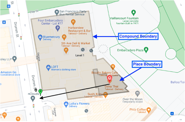
בשדה associatedCompounds בהודעת התגובה של ה-Place Proto, מזהים את המרכיבים המשויכים למקום. ההודעה המורכבת מכילה שלושה סוגים של מידע:

  • סוג המתחם – אחת מארבע אפשרויות
    • compoundBuilding – בניין עצמאי יחיד, כמו קניון או סופרמרקט.
    • compoundSection – מתחם בתוך מתחם גדול יותר, למשל חנות אחת בקניון.
    • compoundGrounds – כל מה שקשור ל-compoundBuilding, למשל קניון, החניון שלו וכל בניין אחר בתוך החניון הזה.
    • unrecognized – ערך ברירת המחדל
  • גיאומטריה – הקואורדינטות של הפוליגון שמתואר, שמאוחסנות במבנה GeoJSON בשדה displayBoundary. הקואורדינטות האלה משמשות ליצירת המתאר של הקטע, המבנה או השטח.
  • כניסות – קואורדינטות קו הרוחב וקו האורך של כל הכניסות והיציאות שנמצאו.

הפונקציה Location Selection מחזירה כל סוג מורכב שמשויך למיקום החיפוש. אם מיקום החיפוש הוא בחנות מסוימת בקניון, התכונה 'בחירת מיקום' מחזירה את הפרטים הבאים: * החנות הספציפית, הכניסות והיציאות שלה והקווים הכלליים של החנות * הבניין המורכב (הקניון), הכניסות והיציאות שלו והקווים הכלליים של הקניון * שטחי המתחם (הקניון + מגרש החניה), הכניסות והיציאות שלהם והקווים הכלליים של כל המתחם

בתמונה הזו מוצגים כל שלושת סוגי התרכובות שמוחזרים.

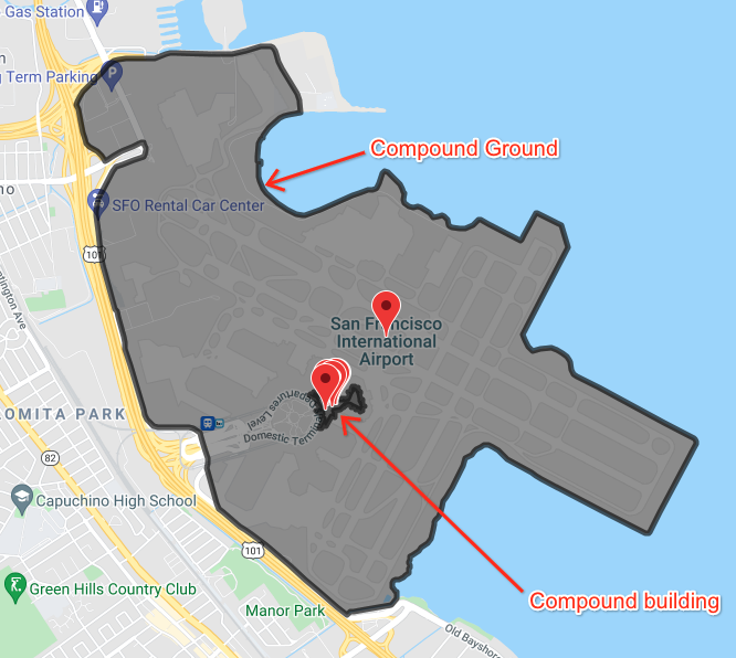
בתמונה הזו מוצגים כמה מיקומים בתוך שדה תעופה, עם הגבול של בניין בתוך שדה התעופה ועם הגבול של שדה התעופה וכל שטחי השירות שלו.