Getting started
Welcome to early access to design features in Google Earth! During the experimental phase, you can generate building and solar designs, view them on the map, and evaluate basic metrics using a site study.
Terms
The following terms apply only to design features in Google Earth to create building and solar designs.
1.1 Commercial Use. Commercial use of the design you create with design features in Google Earth is permitted.
1.2 Disclaimer. Earth design features are intended for conceptual planning and design. Earth design features should not be used for construction or structural engineering designs.
1.3 Early Access. Earth design is still in early access mode. If you are interested in participating in early access for Earth design, please register your interest here. Designs generated during early access mode may not be compatible with future versions of Earth design.
1.4 Changes. Google may change, discontinue, or suspend an early access feature at any time without notice. Early access features may not be compatible with generally available features.
What's new
| Description | Release date (YYYY-MM-DD) |
|---|---|
|
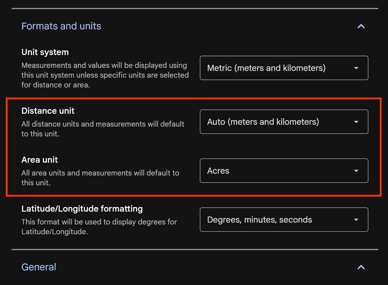
More control and flexibility for units
|
2025-01-06 |
|
Better support for exploring a study's generated designs

Easier building selection and customization

Design generation quality improvements
|
2024-12-05 |
|
Welcome to our first update to design features in Google Earth!
|
2024-10-14 |
Create a site study
You can generate building and solar designs in Earth using a site study. Site studies are saved automatically in Google Drive.
To create a site study, do one of the following:
- From the home screen, select + New > New site study or Create a new project > Create a new site study.
- Open a project and select File > New site study in the menu bar.
Projects and site studies
Projects and site studies are two different kinds of cloud-based projects in Earth. The following table explains capabilities and supported functionalities for each project type.
| Capabilities | Project | Site study |
|---|---|---|
| Content supported | Create customized maps and stories about places around the world with text, photos, and videos. Supports a number of KML features. | Generate, compare, and evaluate building and solar designs to explore development feasibility. |
| Collaboration and sharing | You can share the same project with multiple users and access it across multiple devices. | |
| Access and management | To find all your projects and local KML files, go to the Google Earth home screen. Learn how to manage your projects on Google Earth. | |
Site selection
After creating a site study, you can select a design type, pick an initial site by either drawing parcels or selecting tax lots, and optionally add more parcels. Sites can be as small as 0.5 acres and as large as 10 acres.
- In the "Explore building & solar designs" panel, select either Generate building designs or Explore solar feasibility.
- Search for a location or manually zoom into your chosen location on the map.
Draw a site
- Click Draw site on the right.
- Click the map to set points that outline your parcel.
- To remove a point, click Undo undo on the right.
- To complete your parcel, double-click on your last point.
Select a tax lot
- Click Select tax lots on the right.
- Click the map to select a tax lot.
- To add another tax lot to your parcel, click the map.
- To complete your parcel, click Save on the right.
Add more parcels and finish site selection
- Add additional parcels by drawing them on the map or selecting tax lots.
- After you are done, click Finish site selection.
Create designs
After completing site selection, you can provide inputs to change how designs are generated. Inputs are saved automatically inside of a site study — you can always return to complete them later.
Generate building designs
To generate building designs, Earth takes several inputs into account, including zoning, green space requirements, building types, and sustainability strategies.
- Enter zoning constraints for each parcel in the Site step.
- Enter information about the development program, like the Floor Area Ratio (FAR) or target area for each use type in the Program step.
- Enter information about green space requirements in the Program step.
- Enter parking demand ratios in the Parking step.
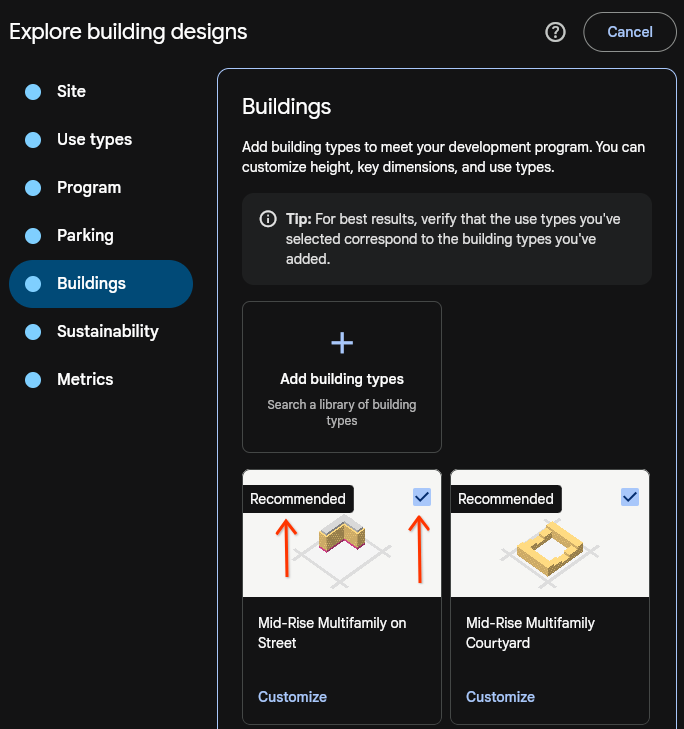
Select building types in the Building types step.
Select sustainability strategies in the Sustainability step.
After entering or adjusting the inputs, click Generate to create your designs.
Explore solar feasibility
To determine solar feasibility for a given site, Earth takes financial assumptions and expected energy usage into account.
- Enter key assumptions in the Financials step.
- Enter energy use in the Energy use step.
- After entering or adjusting the inputs, click Generate to create your designs.
View designs
After generating, designs will appear in 5 to 10 minutes in the left-hand panel. Key information is shown for each design, and clicking on a design will render it on the map and position the camera to display the design in the viewport.
View multiple designs in a list
- Click By type to view designs categorized into solar feasibility or building designs.
- Click By inputs to view designs grouped by creation date and associated inputs.
- Change Sort to modify how designs are ranked.
View a single design on a map
- Click Legend on the map to see the definition for each color rendered in a design on the map.
- Change the style of the map by clicking Layers and selecting an option under Basemap.
Download designs
You can download files for any design using the Download icon. Files contain information about the selected design only.
Known issues
- Adding a building type without adding all the corresponding use types will lead to no designs being generated.
- Metrics don't appear if enabled when generating building designs.
- Sites can't be changed after choosing a design type and starting a draft of inputs.
- Thumbnails and downloaded images will have mesh tearing and other visual artifacts.
- There is noticeable Z-fighting between 2D geometry and the basemap, particularly in "map" mode.
- Listed designs may change sort order if they have the same score, and sometimes overlap on the map.