Page Summary
-
GEDI L2A products provide geolocated elevation and height metrics from GEDI waveforms, with point and raster versions available.
-
GEDI L2B products offer canopy cover and vertical profile metrics extracted from GEDI waveforms.
-
GEDI L4A products provide predictions of aboveground biomass density and standard error estimates within each laser footprint.
-
GEDI L4B offers 1 km x 1 km estimates of mean aboveground biomass density based on GEDI observations.
-
Additional datasets cover global vegetation continuous fields, Canadian national forest inventory data, and detailed forest characteristics for the continental United States.
-
GEDI L2A Raster Canopy Top Height (Version 2)
GEDI's Level 2A Geolocated Elevation and Height Metrics Product (GEDI02_A) is primarily composed of 100 Relative Height (RH) metrics, which collectively describe the waveform collected by GEDI. The original GEDI02_A product is a table of point with a spatial resolution (average footprint) of 25 meters. … elevation forest-biomass gedi larse nasa tree-cover -
GEDI L2A Vector Canopy Top Height (Version 2)
GEDI's Level 2A Geolocated Elevation and Height Metrics Product (GEDI02_A) is primarily composed of 100 Relative Height (RH) metrics, which collectively describe the waveform collected by GEDI. The original GEDI02_A product is a table of point with a spatial resolution (average footprint) of 25 meters. … elevation forest-biomass gedi larse nasa tree-cover -
GEDI L2A table index
This is a feature collection created from the geometries of L2A tables in LARSE/GEDI/GEDI02_A_002. Each feature is a polygon footprint of a source table with its asset id and start/end timestamps. Please see User Guide for more information. The Global Ecosystem Dynamics Investigation GEDI mission … elevation forest-biomass gedi larse nasa table -
GEDI L2B Raster Canopy Cover Vertical Profile Metrics (Version 2)
GEDI Level 2B Canopy Cover and Vertical Profile Metrics product (GEDI02_B) extracts biophysical metrics from each GEDI waveform. These metrics are based on the directional gap probability profile derived from the L1B waveform. The vertical step between foliage profile measurements (known as dZ in GEDI … elevation forest-biomass gedi larse nasa tree-cover -
GEDI L2B Vector Canopy Cover Vertical Profile Metrics (Version 2)
GEDI Level 2B Canopy Cover and Vertical Profile Metrics product (GEDI02_B) extracts biophysical metrics from each GEDI waveform. These metrics are based on the directional gap probability profile derived from the L1B waveform. The vertical step between foliage profile measurements (known as dZ in GEDI … elevation forest-biomass gedi larse nasa tree-cover -
GEDI L2B table index

This is a feature collection created from the geometries of L2B tables in LARSE/GEDI/GEDI02_B_002. Each feature is a polygon footprint of a source table with its asset id and start/end timestamps. Please see User Guide for more information. The Global Ecosystem Dynamics Investigation GEDI mission … elevation forest-biomass gedi larse nasa table -
GEDI L4A Aboveground Biomass Density, Version 2.1
This dataset contains Global Ecosystem Dynamics Investigation (GEDI) Level 4A (L4A) Version 2 predictions of the aboveground biomass density (AGBD; in Mg/ha) and estimates of the prediction standard error within each sampled geolocated laser footprint. In this version, the granules are in sub-orbits. Height metrics … elevation forest-biomass gedi larse nasa tree-cover -
GEDI L4A Raster Aboveground Biomass Density, Version 2.1
This dataset contains Global Ecosystem Dynamics Investigation (GEDI) Level 4A (L4A) Version 2 predictions of the aboveground biomass density (AGBD; in Mg/ha) and estimates of the prediction standard error within each sampled geolocated laser footprint. In this version, the granules are in sub-orbits. Height metrics … elevation forest-biomass gedi larse nasa tree-cover -
GEDI L4A table index
This is a feature collection created from the geometries of L4A tables in LARSE/GEDI/GEDI04_A_002. Each feature is a polygon footprint of a source table with its asset id and start/end timestamps. Please see User Guide for more information. The Global Ecosystem Dynamics Investigation GEDI mission … elevation forest-biomass gedi larse nasa table -
GEDI L4B Gridded Aboveground Biomass Density (Version 2)
This Global Ecosystem Dynamics Investigation (GEDI) L4B product provides 1 km x 1 km estimates of mean aboveground biomass density (AGBD) based on observations from mission week 19 starting on 2019-04-18 to mission week 138 ending on 2021-08-04. The GEDI L4A Footprint Biomass product converts … elevation forest-biomass gedi larse nasa tree-cover -
MOD44B.061 Terra Vegetation Continuous Fields Yearly Global 250m
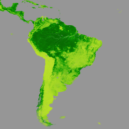
The Terra MODIS Vegetation Continuous Fields (VCF) product is a sub-pixel-level representation of surface vegetation cover estimates globally. Designed to continuously represent Earth's terrestrial surface as a proportion of basic vegetation traits, it provides a gradation of three surface cover components: percent tree cover, percent … annual geophysical global landuse-landcover modis nasa -
SCANFI: the Spatialized CAnadian National Forest Inventory data product1.2

This data publication contains a set of 30m resolution raster files representing 2020 Canadian wall-to-wall maps of broad land cover type, forest canopy height, degree of crown closure and aboveground tree biomass, along with species composition of several major tree species. The Spatialized CAnadian National … canada forest forest-biomass publisher-dataset tree-cover -
USFS TreeMap v2016 (Conterminous United States)
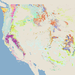
This product is part of the TreeMap data suite. It provides detailed spatial information on forest characteristics including number of live and dead trees, biomass, and carbon across the entire forested extent of the continental United States in 2016. TreeMap v2016 contains one image, a … biomass carbon climate-change conus forest forest-biomass -
USFS TreeMap v2020
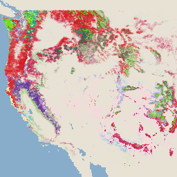
This product is part of the TreeMap data suite. It provides detailed spatial information on forest characteristics including number of live and dead trees, biomass, and carbon across the entire forested extent of the United States in 2020. TreeMap v2020 contains 22-band 30 x 30m … aboveground biomass carbon climate-change conus forest -
USFS TreeMap v2022

This product is part of the TreeMap data suite. It provides detailed spatial information on forest characteristics including number of live and dead trees, biomass, and carbon across the entire forested extent of the United States in 2022. TreeMap v2022 contains 22-band 30 x 30m … aboveground biomass carbon climate-change conus forest