-
DEM 0.5 ม. ของ AHN เนเธอร์แลนด์ที่ประมาณค่า

AHN DEM คือ DEM ขนาด 0.5 ม. ที่ครอบคลุมเนเธอร์แลนด์ โดยสร้างขึ้นจากข้อมูล LIDAR ที่ถ่ายในช่วงฤดูใบไม้ผลิระหว่างปี 2007 ถึง 2012 โดยมีตัวอย่างระดับพื้นดินที่นำรายการอื่นๆ ทั้งหมดเหนือพื้นดินออก (เช่น อาคาร สะพาน ต้นไม้ ฯลฯ) เวอร์ชันนี้คือ … ahn dem elevation elevation-topography geophysical lidar -
DEM 0.5 ม. ของ AHN เนเธอร์แลนด์แบบไม่ประมาณค่า
AHN DEM คือ DEM ขนาด 0.5 ม. ที่ครอบคลุมเนเธอร์แลนด์ โดยสร้างขึ้นจากข้อมูล LIDAR ที่ถ่ายในช่วงฤดูใบไม้ผลิระหว่างปี 2007 ถึง 2012 โดยมีตัวอย่างระดับพื้นดินที่นำรายการอื่นๆ ทั้งหมดเหนือพื้นดินออก (เช่น อาคาร สะพาน ต้นไม้ ฯลฯ) เวอร์ชันนี้คือ … ahn dem elevation elevation-topography geophysical lidar -
AHN Netherlands 0.5m DEM, Raw Samples

AHN DEM คือ DEM ขนาด 0.5 ม. ที่ครอบคลุมเนเธอร์แลนด์ โดยสร้างขึ้นจากข้อมูล LIDAR ที่ถ่ายในช่วงฤดูใบไม้ผลิระหว่างปี 2007 ถึง 2012 เวอร์ชันนี้มีทั้งตัวอย่างระดับพื้นดินและรายการที่อยู่เหนือระดับพื้นดิน (เช่น อาคาร สะพาน ต้นไม้ ฯลฯ) Point Cloud … ahn dem elevation elevation-topography geophysical lidar -
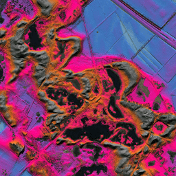
AHN3: AHN 0.5 ม. ของเนเธอร์แลนด์

Actueel Hoogtebestand Nederland (AHN) คือชุดข้อมูลที่มีข้อมูลระดับความสูงที่ละเอียดและแม่นยำสำหรับทั้งประเทศเนเธอร์แลนด์ เราเก็บรวบรวมข้อมูลระดับความสูงจากเฮลิคอปเตอร์และเครื่องบินโดยใช้เทคโนโลยีเลเซอร์ที่มีความแม่นยำในแนวตั้ง 5 ซม. ชุดข้อมูล AHN3 มี DSM AHN 0.5 ม. ของเนเธอร์แลนด์ … ahn dem elevation elevation-topography geophysical lidar -
AHN4: Netherlands AHN 0.5m

Actueel Hoogtebestand Nederland (AHN) คือชุดข้อมูลที่มีข้อมูลระดับความสูงที่ละเอียดและแม่นยำสำหรับทั้งประเทศเนเธอร์แลนด์ เราเก็บรวบรวมข้อมูลระดับความสูงจากเฮลิคอปเตอร์และเครื่องบินโดยใช้เทคโนโลยีเลเซอร์ที่มีความแม่นยำในแนวตั้ง 5 ซม. ชุดข้อมูล AHN4 มี DSM 0.5 ม. ของ AHN ของเนเธอร์แลนด์ … ahn dem elevation elevation-topography geophysical lidar -
ภาพถ่ายออร์โธของเนเธอร์แลนด์
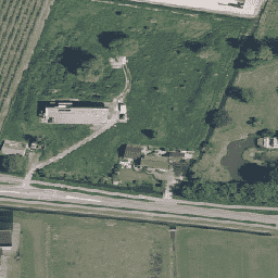
ภาพออร์โธของเนเธอร์แลนด์คือชุดภาพออร์โธสี เราจะรวบรวมภาพถ่ายทางอากาศทั่วประเทศปีละ 2 ครั้ง ได้แก่ ภาพที่ไม่มีใบไม้ที่ความละเอียด 7.5 ซม. ในฤดูใบไม้ผลิ และภาพที่มีใบไม้บนต้นไม้ที่ความละเอียด 25 ซม. ในฤดูร้อน ดูข้อมูลเพิ่มเติมได้ที่ … เนเธอร์แลนด์ ภาพถ่ายทางอากาศ rgb