NEON LiDAR 데이터에서 파생된 표면 (DSM) 및 지형 (DTM)의 디지털 모델입니다. DSM: 표면 특성 (식생 및 인공 구조물이 있는 지형 정보) DTM: 지표면 고도 (식생 및 인공 구조물이 제거된 지형 정보) 이미지는 평균 해수면 위의 미터 단위로 제공됩니다.
가장 가까운 이웃 재샘플링을 사용하여 고정된 균일한 공간 그리드에 모자이크되고 출력되는 고해상도 적색-녹색-청색 (RGB) 정사보정 카메라 이미지입니다. 공간 해상도는 0.1m입니다. 디지털 카메라는 …을 포함하는 NEON 공중 관측 플랫폼 (AOP)의 기기 모음의 일부입니다.
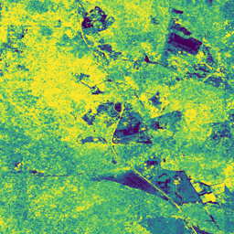
NEON AOP 표면 방향 반사율은 ~380nm에서 2510nm까지의 파장을 포괄하는 426개의 대역을 포함하는 초분광 VSWIR (가시광선에서 단파 적외선) 데이터 제품입니다. 반사율은 10000의 계수로 조정됩니다. 1340~1445nm 및 1790~1955nm 사이의 파장은 …으로 설정됩니다.
[[["이해하기 쉬움","easyToUnderstand","thumb-up"],["문제가 해결됨","solvedMyProblem","thumb-up"],["기타","otherUp","thumb-up"]],[["필요한 정보가 없음","missingTheInformationINeed","thumb-down"],["너무 복잡함/단계 수가 너무 많음","tooComplicatedTooManySteps","thumb-down"],["오래됨","outOfDate","thumb-down"],["번역 문제","translationIssue","thumb-down"],["샘플/코드 문제","samplesCodeIssue","thumb-down"],["기타","otherDown","thumb-down"]],[],[],["NEON data includes the Canopy Height Model (CHM), which estimates canopy height from LiDAR. Digital Elevation Models (DEM) provide surface and terrain information from LiDAR. Directional and Bidirectional Surface Reflectance data offer hyperspectral information across 426 bands, excluding water vapor absorption bands. RGB Camera Imagery provides high-resolution, orthorectified images at 0.1m resolution, collected using an airborne platform. All the data includes information about the forest.\n"]]